Few countries pack as much geographic drama into one border: the world’s second-highest mountain, one of its great rivers, vast deserts and a tropical coastline. This is the complete tour of Pakistan’s physical geography.
Quick answer: Pakistan’s geography spans three mountain systems (Karakoram, Himalaya, Hindu Kush — including K2, 8,611 m), the Indus river plain (the agricultural heartland), the Balochistan plateau, the Thar Desert and a 1,046 km Arabian Sea coast — with climates from arctic to tropical.
In this guide
Mountains
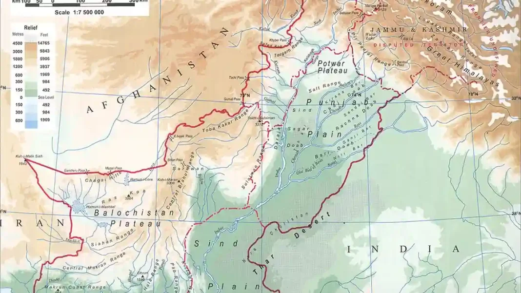
The north is a mountaineer’s impossible dream: the Karakoram (K2, 8,611 m — the world’s second highest), the western Himalaya (Nanga Parbat, 8,126 m) and the Hindu Kush (Tirich Mir, 7,708 m) converge in Gilgit-Baltistan and KP. Pakistan has 5 of the world’s 14 eight-thousanders — more than any country except Nepal and China. South of the high ranges run the Sulaiman and Kirthar ranges along the Afghan and Sindh borders.
Rivers
The Indus — 3,180 km from Tibet to the Arabian Sea — is Pakistan’s lifeline, joined by its tributaries the Jhelum, Chenab, Ravi, Beas and Sutlej (the “five rivers” of Punjab). The Indus Waters Treaty (1960) with India governs their sharing — one of the world’s most successful water agreements, now under strain. Dams: Tarbela (one of the world’s largest earth-filled dams) and Mangla.
Deserts & Plateau
The Thar Desert sprawls across southeastern Sindh into India — dunes, thorn forest and a resilient desert culture. The Cholistan adjoins it in Punjab. Westward, the vast Balochistan plateau — arid mountains and basins — covers 44% of the country with a fraction of its people. The Makran coast runs along the Arabian Sea to Gwadar.
Climate Zones
Four zones: arctic/alpine in the high north (glaciers, -20°C winters), continental in Punjab/KP (hot summers past 45°C, cool winters), arid in Balochistan and Sindh’s interior, and coastal around Karachi (humid, mild). The monsoon (July–September) brings most of the rain — and, increasingly, catastrophic floods like 2022’s. See the terrain: physical map of Pakistan.
Glaciers and Water
Pakistan’s rivers begin as ice: the country holds ~7,000 glaciers — more than anywhere outside the poles — feeding the Indus system that waters 90% of agriculture. The Siachen (76 km), Baltoro and Biafo are among the world’s longest non-polar glaciers. This makes Pakistan’s geography a climate story: glacial melt timing and monsoon shifts decide harvests, floods and power generation. The 2022 super-floods — a third of the country underwater — were geography meeting climate change.
Glaciers and Water
Pakistan’s rivers begin as ice: the country holds ~7,000 glaciers — more than anywhere outside the poles — feeding the Indus system that waters 90% of agriculture. The Siachen (76 km), Baltoro and Biafo are among the world’s longest non-polar glaciers. This makes Pakistan’s geography a climate story: glacial melt timing and monsoon shifts decide harvests, floods and power generation. The 2022 super-floods — a third of the country underwater — were geography meeting climate change.
Frequently Asked Questions
What is Pakistan’s highest point?
K2 at 8,611 metres — the world’s second-highest mountain, in the Karakoram range of Gilgit-Baltistan. Pakistan has five of the world’s fourteen 8,000m peaks.
Which is the longest river in Pakistan?
The Indus — 3,180 km from its source in Tibet to the Arabian Sea near Karachi, joined by the Jhelum, Chenab, Ravi, Beas and Sutlej.