Geographical Features of Pakistan: A Region-by-Region Breakdown
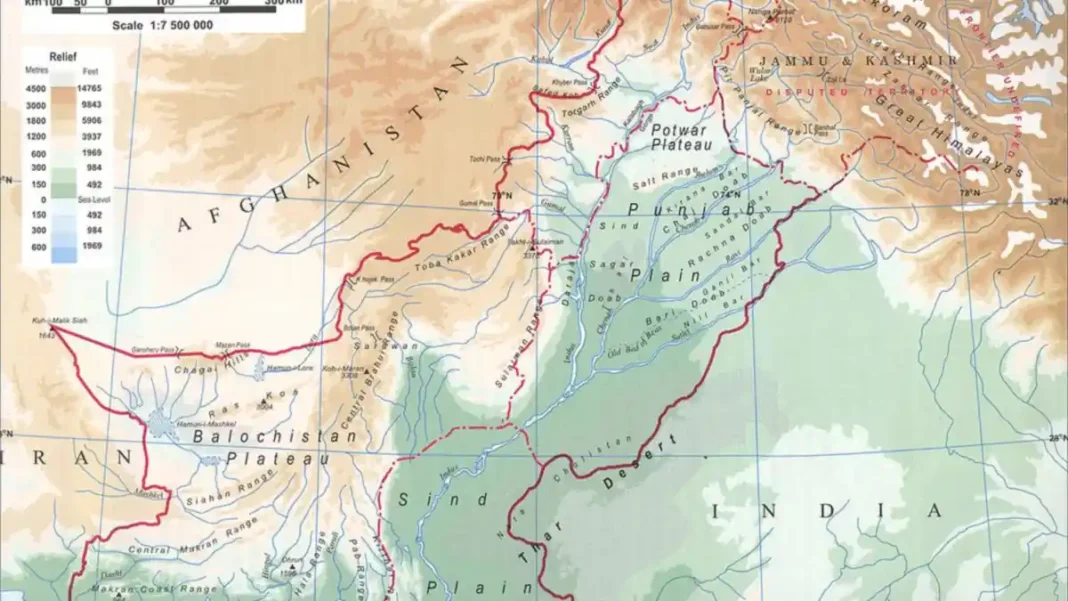
When people ask about the geographical features of Pakistan, they usually want the same thing: a clear picture of how the country’s land is organised. Pakistan’s geography breaks down neatly into a handful of regions — from the towering ranges of Gilgit-Baltistan to the delta coast of Sindh — each with its own terrain, climate and economic role. Here is that picture, region by region.
Quick answer: Pakistan’s geography is divided into the northern highlands (Karakoram, Himalayas, Hindu Kush), the western highlands (Sulaiman, Kirthar, Toba Kakar ranges), the Balochistan plateau, the Salt Range and Potwar plateau, the upper and lower Indus plains, the Thar, Cholistan, Thal and Kharan deserts, and the Makran coastline — spanning 24°–37° N latitude.
In this guide
The northern highlands
The north is Pakistan’s defining geographical feature. Three mountain systems converge in Gilgit-Baltistan and Khyber Pakhtunkhwa: the Karakoram (K2, 8,611 m; four more eight-thousanders; the Baltoro and Siachen glaciers), the Himalayas (Nanga Parbat, 8,126 m), and the Hindu Kush (Tirich Mir, 7,708 m) along the Afghan border. The highlands are the country’s water tower — glacier and snowmelt here feed the entire Indus river system downstream — and its premier tourism asset, from Hunza and Skardu to the valleys of Swat and Kaghan.
The western ranges and plateau
West of the Indus, the terrain changes character. The Sulaiman, Kirthar and Toba Kakar ranges are rugged, dry and rich in passes — the Khyber and Bolan passes have carried trade for centuries. Beyond them lies the Balochistan plateau, an arid tableland at 600–900 m. It is thinly populated and harsh, but mineral-rich: the Chagai hills hold copper and gold (Reko Diq), the Hingol and Dasht rivers drain its centre, and the sandy Kharan basin lies in its far west.
The Salt Range and Potwar plateau
South of the Islamabad region, the Salt Range runs from the Tilla Jogian hills to the Sulaiman foothills — low, mineral-bearing hills (highest point Sakesar, 1,520 m) that hold Khewra, the world’s second-largest salt mine, plus gypsum and limestone. Immediately north, between the Indus and Jhelum rivers, sits the Potwar plateau (300–600 m): rugged, rain-fed country with oil, coal and gas fields and a sharp, dissected landscape.
The Indus plains
South of the Salt Range, the alluvial Indus plains spread across Punjab and Sindh. The upper Indus plain (to Mithankot) is watered by the Indus and its four tributaries — Jhelum, Chenab, Ravi and Sutlej — and served by one of the world’s largest canal irrigation networks. The lower Indus plain runs from Mithankot to the Arabian Sea, irrigated through the great barrages at Sukkur, Guddu and Kotri, and ends in the Indus delta. These plains are the most fertile and densely populated part of Pakistan.
Deserts and the coast
The Thar Desert in south-east Sindh is one of the world’s largest, with shifting dunes and a camel-herding culture; Cholistan adjoins it in Punjab, Thal lies between the Indus and Jhelum, and the Kharan basin sits in western Balochistan. Finally, the Makran coastline — about 1,046 km on the Arabian Sea — runs from Karachi to the Iranian border, backed by steep coastal ranges and home to Port Qasim and the deep-sea port of Gwadar.
For the complete picture with maps, stats and comparison tables, see our full guide to the physical features of Pakistan and the physical features map of Pakistan.
FAQs
What are the geographical features of Pakistan?
Pakistan’s geographical features are the northern highlands (Karakoram, Himalayas, Hindu Kush), the western highlands (Sulaiman, Kirthar, Toba Kakar ranges), the Balochistan plateau, the Salt Range and Potwar plateau, the upper and lower Indus plains, the Thar, Cholistan, Thal and Kharan deserts, and the Makran coastline on the Arabian Sea.
What is the geographical location of Pakistan?
Pakistan lies in South Asia between 24° and 37° North latitude and 61° and 75° East longitude. It is bounded by Iran to the west, Afghanistan to the north-west, China to the north-east, India to the east and the Arabian Sea to the south.
What are the major landforms of Pakistan?
Pakistan’s four dominant landforms are mountains, plateaus, plains and deserts. Mountains cover the north and west, plateaus occupy Balochistan and the Potwar region, plains are the Indus alluvial lands of Punjab and Sindh, and deserts sit in the south-east (Thar, Cholistan) and south-west (Kharan).
What are the three major geographic divisions of Pakistan?
The three major geographic divisions are the northern highlands, the Indus River plain and the Balochistan plateau. Many geographers also distinguish the western highlands, the deserts and the Makran coast as separate divisions.