Black and White Map of Pakistan: A Printable Silhouette for Worksheets
Sometimes colour is the enemy: a photocopier, a classroom printer, or a colouring exercise all call for a black and white map of Pakistan — a clean silhouette that prints sharply, photocopies without muddy greys, and gives students a blank canvas. This guide presents a crisp black-and-white Pakistan map and covers printing, colouring and worksheet use.
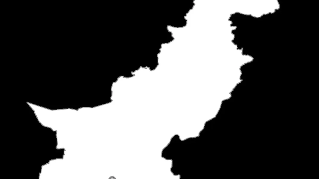
Quick answer: A black and white map of Pakistan is a single-colour silhouette of the country’s borders — no fills, no shading — made for printing, photocopying and colouring. The map featured here is a clean white-on-black silhouette; print it, or invert it for a classic black outline on white paper, then label or colour the provinces yourself.
In this guide
Printing and photocopying tips
The featured silhouette is white on black — striking on screen, but for paper, invert it (any phone photo editor’s “invert colours” does this in one tap) to get a black outline on white. Print at “fit to page” on A4 for individual worksheets or A3 for classroom display. Because the image is pure black and white with no grey shading, it survives photocopying without the muddy halftone mess that colour maps produce. One page, thirty copies, zero toner drama.
Colouring exercises
The classic use: students colour each province differently and add a key — Punjab green, Sindh yellow, KP orange, Balochistan brown is a common classroom convention, though any consistent scheme works. Younger classes can simply colour the whole country green with a white crescent-and-star drawn in, making a flag-map hybrid. Older students can shade by theme: population density (darkest in Punjab), rainfall, or crops, turning the silhouette into a proper thematic map. Our outline map guide lists exactly what to label once the colouring is done.
Building worksheets around it
A black-and-white silhouette is worksheet raw material. Drop it into a document and add: “Label the four provinces and their capitals”, “Shade the province with the largest population”, “Mark the Arabian Sea and the four neighbouring countries”, or “Draw and label the Indus River”. Because the image is high-contrast, it stays legible even when shrunk to half a page beside the questions — something detailed colour maps cannot do.
When to use a different map
Use the black-and-white map when the output is paper. When the output is a screen — a presentation, a video, a web page — the colour-coded picture map or labelled map image will look far better. For Urdu-medium worksheets, pair this silhouette with the Urdu naqsha as the answer key.
Related Guides
Black and white map of Pakistan: FAQs
Where can I print a black and white Pakistan map?
The silhouette featured here is made for printing — save it, invert to black-on-white if you prefer, and print at A4 or A3. It photocopies cleanly with no grey shading.
Can students colour a black and white Pakistan map?
Yes — that is its main classroom use. Colour each province differently and add a key, or shade by a theme like population density.
What is the difference between the outline map and the black-and-white map?
Both are blank. The outline map is a thin line drawing on white; the black-and-white version here is a bolder silhouette — better for small sizes and photocopies.
Is this map up to date?
The silhouette shows Pakistan’s current overall shape. For internal boundaries, check the labelled map image — and remember FATA merged into KP in 2018.