Pakistan Map Image: The Clearest Labelled Map of the Country
Search for a “Pakistan map image” and you get thousands of results — blurry thumbnails, outdated borders, maps that cut off Gilgit-Baltistan or still show the old tribal areas as a separate region. This guide gives you one clean, labelled Pakistan map image you can actually use, explains exactly what it shows, and tells you where each province, capital and major city sits.
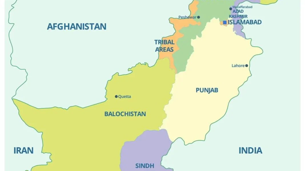
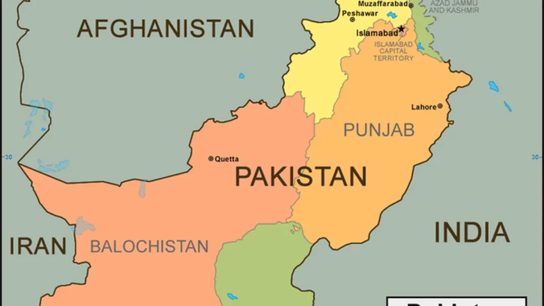
Quick answer: The best Pakistan map image is a labelled political map showing all four provinces (Punjab, Sindh, Khyber Pakhtunkhwa, Balochistan), the federal capital Islamabad, the territories of Azad Jammu and Kashmir and Gilgit-Baltistan, and major cities including Karachi, Lahore, Peshawar, Quetta, Faisalabad and Multan. The map above is our recommended version — detailed, current and free to view.
In this guide
What a good Pakistan map image shows
A useful Pakistan map image does five things at a glance. It outlines the country’s distinctive shape — the long sweep of Balochistan in the southwest, the Punjab wedge in the east, the mountainous north. It colours the four provinces distinctly so you can tell them apart. It marks Islamabad with a capital symbol. It labels the major cities. And it names the neighbours: India, Afghanistan, Iran and China, with the Arabian Sea along the southern coast.
The map image featured with this article meets all five tests. It also shows the administrative territories — Azad Jammu and Kashmir and Gilgit-Baltistan — and marks the Line of Control, the de facto boundary in the disputed Kashmir region. That matters: many free map images online are a decade out of date and still show FATA (the former Federally Administered Tribal Areas) as a separate region, even though it was merged into Khyber Pakhtunkhwa by the 25th Constitutional Amendment in 2018.
The four provinces on the map
Pakistan’s four provinces dominate the map. Punjab, the eastern wedge bordering India, is the most populous — about 127.7 million people at the 2023 census, more than half of all Pakistanis. Sindh runs down the southeast to the Arabian Sea and holds Karachi, the country’s largest city and economic hub. Khyber Pakhtunkhwa stretches along the Afghan border in the northwest. Balochistan, the vast southwestern expanse, covers roughly 44% of Pakistan’s land but holds the smallest population, about 14.9 million. For each province broken out on its own map, see our Pakistan province maps guide.
Major cities and where they sit
On the map image you will find Islamabad (the capital, in the northern Punjab foothills), Karachi (the southern coastal megacity), Lahore (Punjab’s capital, near the Indian border), Peshawar (KP’s capital, near the Khyber Pass), Quetta (Balochistan’s capital, close to the Afghan border), and the Punjab industrial cities of Faisalabad, Multan and Sialkot, plus Hyderabad and Sukkur in Sindh. If you need street-level detail for any of them, our Pakistan city maps guide goes deeper, starting with Lahore.
How to use this map image
This map image works for classroom presentations, quiz preparation, blog illustrations and quick reference. If you are a student, pair it with our blank outline map — study the labelled version, then test yourself on the blank one. For design work, the clipart-style vector map is easier to recolour. For planning travel, switch to the detailed road map, which adds highways and a city-to-city distance chart. And for the full collection, start at our Pak Map hub.
Related Guides
Pakistan map image: FAQs
Where can I download a Pakistan map image in HD?
The featured image on this page is a high-quality labelled map. For photographic-level detail, see our Pakistan map HD guide, which uses high-definition satellite imagery. Save or screenshot the image directly from your browser.
Which Pakistan map image is best for a school project?
For study, this labelled map image is ideal. For the project itself — where you label things yourself — use our blank Pakistan map outline, which is made for colouring and labelling.
Does this Pakistan map image show the current provinces?
Yes. It reflects the current administrative setup: four provinces, the Islamabad Capital Territory, and the territories of Azad Jammu and Kashmir and Gilgit-Baltistan, with FATA merged into Khyber Pakhtunkhwa (2018).
What are the neighbouring countries shown on the map?
India to the east, Afghanistan to the west and northwest, Iran to the west, China to the north, and the Arabian Sea along the southern coast.