Physical Features Map of Pakistan: How to Read the Country’s Landforms
A physical features map of Pakistan is one of the most useful tools for understanding the country: it shows the landforms — mountains, plateaus, plains and deserts — rather than just borders and cities. Once you know how to read the colours and symbols, the map tells the story of why Pakistan’s north is covered in snow, why its centre is a breadbasket, and why its south-east is desert.
Quick answer: On a physical features map of Pakistan, the brown and white patches in the north are the Karakoram, Himalayan and Hindu Kush highlands (K2, 8,611 m); the central greens are the Indus plains of Punjab and Sindh; the tans in the west are the Balochistan plateau; the yellows in the south-east are the Thar and Cholistan deserts; and the blue edge at the bottom is the ~1,046 km Makran coastline on the Arabian Sea.
In this guide
How to read the colours
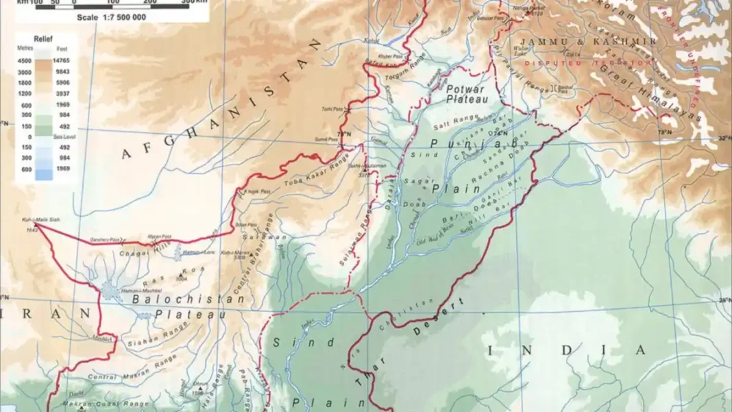
Physical maps use elevation shading: greens for lowlands and plains, yellows and tans for hills and plateaus, browns for high mountains and white for permanent snow and glaciers. Blue marks rivers, lakes and the sea. So on Pakistan’s map, the dark brown cluster in the far north is the Karakoram–Himalaya–Hindu Kush knot, the green band across the middle is the Indus plain, and the blue thread running the country’s length is the Indus River itself (about 1,609 km), with the Jhelum, Chenab, Ravi and Sutlej joining it from the east.
What to find in the north
In the northern highlands, look for K2 (8,611 m) in the Karakoram, Nanga Parbat (8,126 m) in the Himalayas and Tirich Mir (7,708 m) in the Hindu Kush. The white glacier tongues — Baltoro, Siachen — are easy to spot. Note how the ranges form a great arc, and how the valleys (Hunza, Skardu, Swat, Chitral) sit tucked between them — these are the places featured in our beautiful valleys of Pakistan round-up.
What to find in the centre
South of the Salt Range, the green alluvial plain of the Indus spreads across Punjab and Sindh — the upper plain to Mithankot, the lower plain to the sea. On the map, trace the Salt Range as a low ridge across northern Punjab and the Potwar plateau just north of it. To the west, the Sulaiman and Kirthar ranges appear as tan ridges, and beyond them the broad, tan Balochistan plateau fills the south-west.
What to find in the south and east
In the south-east, the yellow expanse of the Thar Desert marks the border with India, with Cholistan beside it in Punjab; the Thal desert sits between the Indus and Jhelum, and the Kharan basin in the far west. At the bottom edge, the Makran coast runs ~1,046 km along the Arabian Sea — find Karachi, then the Makran range hugging the shore westward to Gwadar.
The best physical maps to use
For study purposes, freely licensed options include the “Physical Map of Pakistan” on Wikimedia Commons (CC BY-SA 4.0) — a clear, labelled relief map ideal for school and reference use — and the CIA World Factbook’s physical map. When using any map in your own work, check its licence: Wikimedia Commons maps are usually free to reuse with credit, while textbook and atlas maps are copyrighted. Our own full guide to Pakistan’s physical features explains every region these maps show, and the region-by-region geographical breakdown walks through them one at a time.
FAQs
What does a physical features map of Pakistan show?
It shows Pakistan’s landforms — mountains, plateaus, plains, deserts and rivers — using elevation colours rather than political borders. You can see the Karakoram, Himalayan and Hindu Kush ranges in the north, the Indus plains in the centre, the Balochistan plateau in the west, the Thar Desert in the south-east and the Makran coast along the Arabian Sea.
Where can I find a physical map of Pakistan for free?
The “Physical Map of Pakistan” on Wikimedia Commons is freely licensed (CC BY-SA 4.0) and clear for study and reference use. The CIA World Factbook also publishes a physical map of Pakistan. Always check the licence before republishing any map — credit the source.
What are the colours on a physical map of Pakistan?
Green marks the lowlands (the Indus plains), yellow and tan mark hills and plateaus (Balochistan plateau, deserts, Salt Range), brown marks high mountains (the northern highlands), white marks snow and glaciers, and blue marks rivers and the Arabian Sea.
Where is K2 on the map of Pakistan?
K2 (8,611 m) sits in the far north in the Karakoram range, in Gilgit-Baltistan, near the border with China. On a physical map it appears in the dark-brown, highest-elevation cluster — Pakistan’s tallest point and the world’s second-highest mountain.