Quick Facts
- Location: Hispar Muztagh, Karakoram range, above Shishkat/Hispar in Gilgit-Baltistan, Pakistan
- Altitude: 7,885 metres (25,869 ft) — the highest mountain of the Hispar Muztagh, the 19th-highest mountain on Earth and the 7th-highest in Pakistan
- Famous For: a three-kilometre summit ridge above 7,400 metres; one of the great expedition peaks of the Karakoram; the classic Hispar Glacier trek beneath it
- Nearest City: Gilgit, via Nagar and Hispar village
- Accessibility: jeep road to Hispar village, then a multi-day glacier trek; Gilgit Airport is the nearest air link
- Known Landmarks: Hispar Glacier, Hispar La, Kunyang Glacier, Hispar village
- Best For: serious trekkers, mountaineering-history enthusiasts, photographers of big Karakoram walls, and travellers who want the deepest Karakoram without the Baltoro crowds
Why Visit Distaghil Sar
Let us be honest from the start: you are almost certainly not going to climb Distaghil Sar. At 7,885 metres, with a three-kilometre-long summit ridge floating above 7,400 metres and approaches guarded by some of the most complex glacier terrain in the Karakoram, this is a mountain for elite expeditions — a peak that has seen only a handful of ascents since Austrians first stood on top in 1960. But here is the thing: you do not need to climb Distaghil Sar for it to be one of the great destinations in Pakistan. You need to walk beneath it.
Distaghil Sar is the crown of the Hispar Muztagh, the highest summit of its own subrange, and it anchors one of the most spectacular trekking arenas on earth: the Hispar Glacier, a river of ice around 49 kilometres long that runs from the high snows down to the village of Hispar in Nagar. Walking the Hispar is the connoisseur’s alternative to the Baltoro trek — the same scale of Karakoram grandeur, the same 7,000-metre walls closing in on every side, with a fraction of the foot traffic. And presiding over it all, visible for days of walking, is the long white ridge of Distaghil Sar.
The name itself is worth the trip. In Burushaski, the language of Hunza and Nagar, “Distaghil Sar” means “Sheepfold in the Hills” — a humble, pastoral name for the 19th-highest mountain on the planet, and a reminder that long before climbers arrived with their ropes and oxygen, this was simply the great white presence above the summer pastures. That layering — ancient pastoral life below, modern mountaineering legend above — is what makes the Hispar region so compelling.
This destination is perfect for experienced trekkers who have done the standard northern circuit and want the next level, for photographers chasing the great unclimbed-looking walls of the Hispar Muztagh, and for anyone fascinated by mountaineering history who wants to stand where the 1960 Austrian expedition walked in. It is not a family picnic spot and it is not a weekend trip — it is a genuine expedition into the deep Karakoram, and it will recalibrate your sense of what “big mountains” means.
History of Distaghil Sar
The climbing history of Distaghil Sar is a short, serious chronicle. The mountain was first climbed on 9 June 1960 by Günther Stärker and Diether Marchart, members of an Austrian expedition, via the mountain’s long ridges. It was a notable achievement: at 7,885 metres, Distaghil Sar was among the highest peaks yet climbed, and its three-kilometre summit ridge above 7,400 metres — with three distinct summits (the Northwest at 7,885 m, the Central at 7,760 m, and the Southeast at around 7,696 m) — made it a complex, committing objective.
What followed was not a rush of ascents but a long, respectful silence punctuated by occasional expeditions. Distaghil Sar never became a commercial peak. Its approaches are long, its weather is Karakoram-severe, and the neighbouring giants of the Hispar Muztagh — Kunyang Chhish (7,852 m), Kanjut Sar (7,760 m) — absorbed much of the exploratory attention. The mountain remains, by the standards of the 8,000-metre circus, a quiet giant: climbed rarely, attempted seriously, and still carrying the aura of the golden age of Himalayan exploration.
The human history beneath the peak is far older. The Hispar Glacier has been a highway for centuries: the Hispar La, the high pass at its head (around 5,100 metres), links Nagar with Baltistan, and generations of Balti and Burusho porters, traders and herders have crossed it. The Biafo and Hispar glaciers together form one of the longest glacial systems outside the polar regions — a continuous river of ice that has shaped life, language and legend on both sides of the divide.
On the Nagar side, the valleys below Distaghil Sar belonged to the old principality of Nagar, independent for more than 1,200 years under its own Mirs until the British asserted control during the Anglo-Brusho war of 1891, fought at Nilt that December. Hispar village, the last settlement before the glacier, is a place where that history is still tangible: stone houses, ancient irrigation channels, and families who have supplied porters to expeditions for generations.
Top Things to Do in Distaghil Sar
Trek the Hispar Glacier Toward Base Camp
The essential Distaghil Sar experience. From Hispar village (around 3,100 metres), the trail follows the lateral moraine of the Hispar Glacier upward, with the icefall-churned glacier on one side and the towering walls of the Hispar Muztagh — including Distaghil Sar’s great ridge — dominating the view. This is a serious multi-day trek, typically 7–10 days return to the upper glacier and back, on rough moraine with real altitude. Go with an experienced local operator, full camping kit, and porters from Hispar village, whose men know this glacier intimately.
Stand at the Foot of the Three-Kilometre Ridge
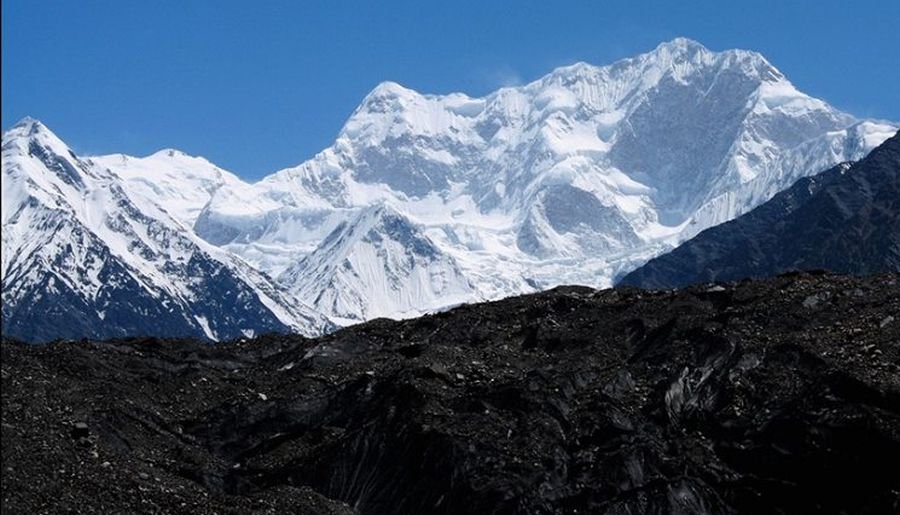
From the upper Hispar Glacier, Distaghil Sar reveals its defining feature: the immensely long summit ridge, three kilometres of snow and ice above 7,400 metres with its three summits strung along it. Few mountain views in the Karakoram convey scale the way this does. Photographers should plan for the clear, cold light of early morning, when the ridge burns white-gold against a deep blue sky.
Cross or View the Hispar La
The historic pass at the head of the glacier (around 5,100 m) is the gateway to the legendary Biafo–Hispar traverse — one of the great high walks of the world, crossing Snow Lake to Askole in Baltistan. The full traverse is a 2–3 week expedition; even reaching the La and looking across is a serious achievement. Most Distaghil Sar trekkers content themselves with views of the pass from the upper glacier.
Meet the Porters and Herders of Hispar Village
Hispar is the last village of Nagar, a compact settlement of stone houses at the edge of the ice. Spend a day here before your trek: walk the irrigation channels, drink tea with the families who will carry your loads, and understand the mountain economy that has sustained Karakoram expeditions for a century. The village’s apricot orchards, at over 3,000 metres, are among the highest cultivated in the region.
Photograph Kunyang Chhish and the Muztagh Walls
Distaghil Sar does not stand alone. Its neighbours — the sharp, difficult spire of Kunyang Chhish (7,852 m), the broad mass of Kanjut Sar — crowd the horizon. The Hispar Muztagh is a photographer’s range precisely because it is less photographed than the Baltoro giants; every frame feels like a discovery. For more Karakoram ice, see our Baltoro Glacier travel guide.
Famous Places In and Around Distaghil Sar
- Hispar Village — last settlement of Nagar; trek trailhead at ~3,100 m
- Hispar Glacier — ~49 km of ice beneath Distaghil Sar’s ridge
- Hispar La — historic high pass (~5,100 m) linking Nagar and Baltistan
- Kunyang Glacier & Kunyang Chhish — the neighbouring 7,852 m giant
- Hopar Valley & Hoper Glacier — lower Nagar’s glacier valley, on the approach road
- Karimabad, Hunza — forts and bazaars across the river; see our Explore Hunza Valley guide
How to Reach Distaghil Sar
Reaching Distaghil Sar means reaching Hispar village in Nagar District — the end of the road and the start of the glacier. This is a longer, rougher approach than the popular Hunza and Skardu trailheads, which is exactly why the region stays wild.
From Islamabad: Drive the Karakoram Highway to Gilgit — around 510 km, 10 to 12 hours. From Gilgit, take the Nagar road up to Nagar Khas, then continue by jeep via Hopar to Hispar village — a half-day of mountain driving (roughly 3–4 hours from Gilgit, depending on road conditions). Most trekkers overnight in Gilgit or Karimabad before the final push.
From Lahore: Motorway to Islamabad (about 375 km), then the KKH to Gilgit and onward to Hispar as above. This is a three-day journey by road for most travellers.
From Karachi: Fly to Islamabad, then road or PIA flight to Gilgit, then jeep to Hispar. Allow a minimum of three travel days from Karachi to the trailhead.
Nearest airport: Gilgit Airport (PIA from Islamabad, ~45 minutes, weather-dependent). Skardu is the backup, with a longer overland connection via the KKH.
Road conditions by season: The Gilgit–Nagar–Hispar jeep road is typically open from late May to October. Landslides are common after rain; the road beyond Hopar is rough and strictly 4×4 territory. In winter, Hispar village is snowbound and the glacier trek is impossible.
Transport options: Hire a 4×4 with driver in Gilgit — do not attempt the Hispar road in a normal car. Trekking operators in Gilgit, Hunza and Skardu run Hispar Glacier expeditions that bundle transport, guides, porters, food and camping gear; for a trek of this seriousness, going with an operator is strongly advised.
Route Details
- Islamabad → (KKH) → Gilgit: ~510 km, 10–12 hours by road, or a short flight when weather allows.
- Gilgit → Nagar Khas → Hopar → Hispar village: roughly 3–4 hours by 4×4, the last stretch rough.
- Hispar village (~3,100 m) → lateral moraine camps: 2–3 days of load-carrying and acclimatisation.
- Up the Hispar Glacier toward base-camp zones beneath Distaghil Sar: 3–4 more days, camping on the moraine.
- Summit views and exploration, then retrace to Hispar village — allow 7–10 days round trip from the village.
Where to Stay in Distaghil Sar
There are no hotels on the glacier — this is a full expedition trek, and you sleep in tents. Your nights under a roof will be in Hispar village and on the approach.
Hispar village: Simple village guesthouses offer basic rooms and home-cooked meals — book through your trekking operator, who will have standing arrangements. The hospitality is genuine and the food is hearty.
Mid-range: Hotels and guesthouses in Nagar Khas and Karimabad (Hunza) provide comfortable bases before and after the trek, with hot showers and proper beds you will appreciate enormously on return.
Luxury: The Serena hotels in Karimabad are the region’s premium option for a recovery night or two — terraces with views back toward the Muztagh you just walked beneath.
Camping: On the glacier, camp on the lateral moraine at established sites used by expeditions for decades. Your operator provides the full camp; the only luxury is the view.
Where to Eat: Local Foods of Distaghil Sar
On the trek, you eat what your expedition cook prepares — typically a mix of Pakistani staples (daal, rice, chapati, chicken) and local mountain food. In Hispar village and Nagar, seek out the valley’s own dishes.
Chapshuro, the minced-meat wholewheat pie baked on hot stones, is the signature dish of Nagar and Hunza. Mamtu (steamed dumplings), dawdo (hand-pulled noodle soup) and gyaling (buckwheat pancakes) are the warming staples of high villages. Diram fitti, sweet bread rich with apricot kernels and walnuts, is served to guests. Wash it down with tumoro cha, salty butter tea — an acquired taste that becomes essential at altitude.
Village meals are inexpensive and generous; a full dinner in a Hispar or Nagar guesthouse costs a few hundred rupees per person. In Karimabad’s tourist restaurants, expect to pay more for international menus. Carry high-energy snacks (dried apricots, walnuts, chocolate) from Gilgit for the trek — the glacier burns calories fast.
Weather in Distaghil Sar
Hispar village sits at around 3,100 metres, and the upper glacier camps are far higher and colder — assume temperatures 10–15 degrees lower than the village and snow possible in any month. The table below gives approximate ranges for the Hispar valley zone.
| Season | Temperature Range | Conditions |
|---|---|---|
| Winter (Dec–Feb) | -15 to -2°C | Deep snow; village cut off; glacier trekking impossible |
| Spring (Mar–May) | -2 to 12°C | Thaw begins; road opens late May; unstable snow on glacier |
| Summer (Jun–Aug) | 8 to 22°C | Trekking season; long days, stable-ish weather, afternoon cloud |
| Autumn (Sep–Nov) | -8 to 10°C | Clear, cold, golden; snow returns to high camps by late October |
Language and Culture of Distaghil Sar
The valleys below Distaghil Sar are Burushaski-speaking (the Burusho people of Nagar and Hunza), with Shina widely spoken and Wakhi heard in upper Hunza settlements. Urdu works in the bazaars. The population is predominantly Ismaili Muslim, and the region is known for its high literacy, its respect for education — including for girls — and its easy welcome to travellers.
Expedition culture runs deep here: Hispar’s men have worked as high-altitude porters for generations, and the relationship between villagers and climbers is one of mutual professional respect. If you trek with local porters, treat them as the experts they are — follow their advice on the glacier without argument. Dress modestly in villages, ask before photographing people, and never walk through standing crops or irrigation channels.
Shopping in Distaghil Sar
Hispar village has only the smallest shops — buy all trekking supplies, snacks and spare batteries in Gilgit. What is worth buying here: dried apricots from 3,000-metre orchards (some of the sweetest in the Karakoram), apricot kernel oil, and hand-knitted woollens. For handicrafts — embroidered Hunza caps, shawls, carved wood — stop at Karimabad’s bazaar on your way through. There are no shopping malls in Nagar district, and none are needed.
Local Events and Festivals
Nagar shares Hunza’s festival calendar. Navroz (21 March), the Ismaili new year, brings prayers, music and communal feasts. Ginani, the traditional harvest festival usually celebrated in June after the wheat harvest, is the cultural highlight — folk dancing, music and, in some years, polo. Dates vary slightly, so confirm locally before building an itinerary around them.
Travel Tips for Distaghil Sar
Packing Essentials
Expedition-grade gear: four-season tent and sleeping bag (rated well below freezing), insulated boots, crampons if your operator advises, layered clothing, glacier sunglasses and high-SPF sunscreen, headlamp with spare batteries, water purification, and a comprehensive first-aid kit including altitude medication (consult your doctor). Bring every rupee you will need in cash from Gilgit.
Safety Tips
This is serious mountaineering terrain. Never trek the Hispar Glacier without an experienced local guide and proper equipment — crevasses are real and often hidden. Acclimatise carefully: Hispar village at 3,100 m is already high, and the glacier camps are much higher. Weather can change in minutes; carry storm gear always. Register your expedition with the relevant authorities through your operator, and carry a satellite communicator — there is no mobile signal on the glacier.
Money & Connectivity
Cash only, from Gilgit — there are no ATMs in Nagar beyond the main towns, and none in Hispar. SCom/Telenor/Zong signals reach Hispar village but die on the glacier. Download offline maps, and let your operator handle emergency communications.
Best Time to Visit Distaghil Sar
Summer (June–August): Expedition Season
The only realistic window for the Hispar Glacier trek. The jeep road is open, the glacier is at its most stable, and the long days give you time for the slow moraine walking. July is peak season — book operators and porters well ahead.
Autumn (September–Early October): Clear and Cold
Superb clarity and golden light for photography, far fewer people, but bitterly cold nights on the glacier and a real chance of early snow closing the high camps. For experienced, well-equipped trekkers only.
Spring (May): Marginal
The road may just be opening and the village waking up, but the glacier is still in winter condition — not a trekking season.
Winter (November–April): Closed
Hispar is snowbound and the glacier is out of reach. The mountain waits; come back in summer.
Final Thoughts
Distaghil Sar is not a destination you tick off — it is a destination you earn. The jeep road to Hispar, the days of moraine walking, the cold camps beneath a three-kilometre ridge at 7,400 metres: all of it asks more of you than the standard northern circuit. And all of it gives more back. To stand on the Hispar Glacier with the “Sheepfold in the Hills” filling half the sky is to understand the Karakoram at full scale, the way the great expeditions of the 1960s understood it.
Go with a good operator, go in high summer, and go with respect — for the glacier, for the porters of Hispar, and for a mountain that has kept its dignity by refusing to become easy. Distaghil Sar will not be the most-visited peak on your list. It may be the most-remembered. For more deep-Karakoram inspiration, browse our Explore Pakistan collection.
FAQs
Where is Distaghil Sar located?
Distaghil Sar (7,885 m) stands in the Hispar Muztagh subrange of the Karakoram in Gilgit-Baltistan, Pakistan, above the Hispar Glacier near Shishkat/Hispar, approached via Hispar village in Nagar District.
What is the best time to visit Distaghil Sar?
June to August for the Hispar Glacier trek; September to early October for clear, cold photography conditions. The region is snowbound and inaccessible from November to April.
How do I reach Distaghil Sar?
Drive or fly to Gilgit, take a 4×4 via Nagar and Hopar to Hispar village (roughly 3–4 hours), then trek 7–10 days round trip up the Hispar Glacier with a guide, porters and full camping gear.
Is Distaghil Sar safe for tourists?
The trek is safe with an experienced local operator, proper gear and acclimatisation. The mountain itself is for elite expeditions only — crevasses, avalanches and extreme altitude make unguided travel dangerous.
Is Distaghil Sar suitable for families?
No — this is an expedition-grade trek, not a family outing. Families should enjoy Nagar and Hunza’s valleys, villages and forts instead, and view the peak from afar.
Where can I stay near Distaghil Sar?
Simple guesthouses in Hispar village, hotels in Nagar Khas and Karimabad (including Serena Hunza for a luxury recovery night), and expedition camping on the glacier itself.
What local food should I try?
Chapshuro (meat pie), mamtu (dumplings), dawdo (noodle soup), diram fitti (apricot-walnut sweet bread), salty butter tea, and high-altitude dried apricots.
Who first climbed Distaghil Sar?
Austrian climbers Günther Stärker and Diether Marchart made the first ascent on 9 June 1960. The mountain’s Burushaski name means “Sheepfold in the Hills”.