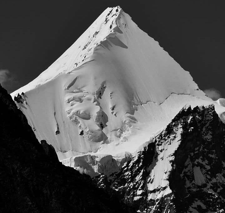
High in the Baltoro Muztagh of the Karakoram, on the southwest ridge of K2 itself, rises a sharp, elegant pyramid that most trekkers know simply as Angel Sar — also called Angelus or Angel Peak. At around 6,802 metres (22,316 feet), it is far from the highest summit in the range, yet it is one of the most photographed: from the Concordia campsite, where the Baltoro, Godwin-Austen and Vigne glaciers meet, Angel Sar catches the first light of dawn while K2 still sleeps in shadow, and photographers from around the world wait for exactly that moment.
This Angel Sar travel guide is written for the two kinds of travellers who encounter this mountain: trekkers walking the legendary K2 base camp route who want to know the peak glowing above their tent, and mountaineers researching one of the Karakoram’s classic 6,000-metre objectives. Here you will find the verified climbing history of Angel Sar, how to reach Concordia from Skardu and Askole, the best time to visit, permit and logistics essentials, and practical advice for the high Karakoram. For more northern adventures, see our Hunza Valley guide and the Explore Pakistan collection.
Quick Facts
- Location: Baltoro Muztagh, Karakoram range, Shigar district, Gilgit-Baltistan, Pakistan — on the southwest ridge of K2
- Altitude: Around 6,802 metres (22,316 ft); some sources cite 6,858 m (22,500 ft)
- Famous For: Its striking pyramid shape and the famous dawn light it catches above Concordia; first climbed in 1983
- Nearest City: Skardu, the expedition hub of Baltistan
- Accessibility: Expedition and serious trekking only — reached via the K2 base camp / Concordia trek from Askole; no road access
- Known Landmarks: Concordia, K2 base camp, Broad Peak, Gasherbrum IV, Mitre Peak, Baltoro Glacier
- Best For: Experienced mountaineers, Concordia trekkers, high-altitude photographers
Why Visit Angel Sar
Let us be honest from the start: almost nobody “visits” Angel Sar the way you visit a lake or a fort. There is no road, no hotel, no viewpoint parking lot. You meet this mountain the way mountaineers have always met great peaks — after days of walking up the Baltoro Glacier, sleeping in tents at 4,000 metres and more, until one evening you round a moraine ridge and the whole upper Baltoro opens in front of you. K2 dominates, of course, but ask any Concordia trekker which summit they remember most fondly and many will name the smaller, shapelier pyramid glowing pink at sunrise. That is Angel Sar.
For trekkers, Angel Sar is the aesthetic reward of the K2 base camp trek, widely considered one of the greatest walks on earth. The mountain sits inside the Central Karakoram National Park, surrounded by four 8,000-metre giants, and its position on K2’s own ridge gives it a pedigree few 6,000-metre peaks can claim. Watching dawn strike Angel Peak from a sleeping bag at Concordia is one of those travel moments people describe for the rest of their lives.
For climbers, Angel Sar is a serious but achievable Karakoram objective with a clean history: a single well-documented first ascent in 1983 and very few repeats, which means genuine adventure on a peak that is not overcrowded. It demands full expedition logistics — permits, high-altitude porters, fixed ropes and a weather window — but that is precisely the appeal. If your idea of travel is measured in vertical metres and glacier camps rather than hotel stars, this Angel Sar travel guide will help you plan properly.
History of Angel Sar
The human history of the Karakoram is short and intense, and Angel Sar’s story belongs to the golden age of Himalayan and Karakoram exploration. The Baltistan region was for centuries a remote mountain kingdom with Tibetan cultural roots, largely unknown to the outside world until British and European explorers began mapping the Karakoram in the 19th century. The great surveyors gave the region’s peaks their first recorded names and heights, and the Baltoro Glacier became famous among geographers as the largest glacier outside the polar regions.
The modern climbing era began with K2 itself. After early reconnaissance, the second-highest mountain on earth was finally climbed on 31 July 1954 by Achille Compagnoni and Lino Lacedelli of the Italian expedition led by Ardito Desio. That triumph opened the Karakoram to the world’s mountaineers, and through the 1960s and 1970s expedition after expedition worked its way up the Baltoro, ticking off the great summits: Broad Peak, the Gasherbrums, and the satellite peaks around them.
Angel Sar was first climbed on 9 August 1983 by Michel Afanassieff and Claude Stucki. The peak — listed in climbing records under the names Angel Sar, Angelus and Angel Peak — had waited while its giant neighbours took the headlines, and the 1983 ascent put it firmly on the mountaineering map. Since then it has seen only occasional attempts, which is why it retains the aura of a true expedition peak rather than a commercial one. The mountain lies within the Central Karakoram National Park, established in 1993 to protect this extraordinary landscape, and all climbing here is regulated through the Gilgit-Baltistan authorities.
The trekking history matters too. The K2 base camp trek via Askole and Concordia was pioneered as a commercial trekking route in the 1970s and 1980s, and today it draws several thousand trekkers in a good season. Every one of them walks beneath Angel Sar’s east face on the final approach to Concordia — making this one of the most seen, and least climbed, beautiful peaks in the Karakoram.
Top Things to Do in Angel Sar
See it at dawn from Concordia
This is the essential Angel Sar experience and it requires no climbing at all — just a Concordia trek. Camp at Concordia (around 4,700 m), set an alarm before sunrise, and watch the first light ignite Angel Peak while the great 8,000-metre summits are still dark. Photographers consider this one of the finest dawn views in the Karakoram. A tripod, a warm down jacket and a thermos of tea are the only equipment you need.
Trek the K2 base camp route
The full trek from Askole to Concordia and K2 base camp takes roughly 8 to 10 days of walking each way, crossing the Baltoro Glacier past famous landmarks like Urdukas, Goro II and the great granite towers of Trango. Angel Sar accompanies you for the final days, growing larger with every camp. This is a strenuous high-altitude trek requiring a licensed guide, porters and full camping equipment — not a casual walk.
Climb it — for experienced mountaineers only
Angel Sar is a legitimate 6,800-metre mountaineering objective. An expedition needs a climbing permit from the Gilgit-Baltistan Council, a licensed Pakistani tour operator, high-altitude porters, base camp infrastructure and a full technical rack. The climbing season is short — essentially June through August — and the weather window must be chosen with care. Only teams with prior 6,000-metre-plus experience should consider it.
Photograph the Baltoro panorama
Even if you never leave the trekking route, the area around Concordia offers the densest concentration of great mountain photography on the planet: K2, Broad Peak, the Gasherbrums and Angel Sar in a single 360-degree sweep. The best light is early morning and late evening; midday the high white peaks wash out.
Famous Places In and Around Angel Sar
- Concordia — the legendary glacier junction and campsite with the classic Angel Sar dawn view
- K2 Base Camp — at the foot of the world’s second-highest mountain, a further trek from Concordia
- Broad Peak Base Camp — beneath the world’s 12th-highest mountain
- Gasherbrum IV — the “shining wall,” one of mountaineering’s most coveted faces
- Mitre Peak — the unmistakable pointed summit guarding the upper Baltoro
- Trango Towers — granite big-wall climbing meccas passed en route up the Baltoro
How to Reach Angel Sar
There is exactly one practical way to reach the Angel Sar region: fly or drive to Skardu, drive the jeep track to Askole, and trek. There are no shortcuts, and that is part of the point.
From Islamabad: Fly to Skardu (about 1 hour, weather permitting — flights are frequently delayed or cancelled, so keep buffer days). Alternatively, drive the Karakoram Highway and Skardu road: roughly 640 km and 14 to 18 hours via Mansehra, Babusar (in summer) or the KKH through Besham. Most expeditions and trekking groups fly in and drive out, or vice versa.
From Lahore: Fly Lahore–Islamabad–Skardu, or drive to Islamabad first (about 4–5 hours) and continue as above. There are no direct commercial flights from Lahore to Skardu on most schedules.
From Karachi: Fly to Islamabad and connect to Skardu. The overland journey from Karachi to Skardu takes the best part of three days and is not recommended for a trek with fixed dates.
Nearest airport: Skardu International Airport. Skardu to Askole: a rough jeep track of around 120+ km taking 6 to 8 hours — itself an adventure, crossing the Braldu river valley. Askole to Concordia: 8 to 10 days of trekking with porters, camping at Paiju, Urdukas, Goro and Concordia. Transport options: You cannot do this route independently in the casual sense — hire a licensed trekking company in Skardu that provides the guide, cook, porters, tents, food and the required permits. For climbing expeditions, a registered tour operator is mandatory for the permit application.
Route Details
- Islamabad → Skardu (by air, or by road via the KKH/Skardu road).
- Skardu → Askole by 4×4 jeep (6–8 hours on a rough mountain track; overnight in Askole).
- Askole → Jhola → Paiju → Urdukas → Goro I → Goro II → Concordia (trekking days, with rest/acclimatisation).
- Concordia → Angel Sar views at dawn; optional continuation to K2 base camp.
- Climbing expeditions establish base camp on the appropriate glacier and work the route in the June–August window.
Where to Stay in Angel Sar
There are no hotels anywhere near Angel Sar — accommodation means tents, and the only roofed nights are in Skardu and Askole before and after the trek. Plan accordingly.
Skardu (mid-range and budget hotels): Skardu has the full range from comfortable mid-range hotels with hot water and restaurants down to simple guesthouses near the bus stands. Expedition teams usually base themselves here for several days of preparations, briefings and shopping. Book ahead in the June–August season.
Askole (basic guesthouses and camping): The last village on the route has very basic guesthouse rooms and camping space. Most groups sleep one night here before starting the trek.
On the trek (expedition tents): Your trekking company provides sleeping tents, mess tents, mattresses and all camp logistics. At Concordia and other camps there are no permanent structures — only the tents of the season’s expeditions. A good sleeping bag rated well below freezing is non-negotiable.
Where to Eat: Local Foods of Angel Sar
On the mountain you eat what the expedition cook prepares — typically a mix of Pakistani staples and trekking food. In Skardu, however, you can taste genuine Balti cuisine before you leave for the glacier.
Try balay (hand-pulled noodle soup), gyal (buckwheat pancakes), prapoo and the local apricot-based dishes — Baltistan’s dried apricots are famous across Pakistan. Butter tea (qehwa/chai) is the traditional high-mountain drink. In Skardu town, restaurants also serve standard Pakistani food: chicken karahi, daal, chapli kebab and fresh tandoori roti. Once on the trek, expect rice, lentils, pasta, soup and porridge — simple, high-energy food, with costs covered in your trek package. Carry personal snacks (nuts, chocolate, energy bars) from Skardu, as nothing is available for purchase beyond Askole.
Weather in Angel Sar
Angel Sar sits in a tundra climate zone: cold, snowy winters and cool summers, with heavy precipitation driven by orographic lift as weather systems hit the Karakoram wall. The climbing and trekking season is brutally short. The figures below are approximate for the trekking altitudes (4,000–5,000 m); the summit is far colder and windier.
| Season | Temperature Range (at trek camps) | Conditions |
|---|---|---|
| Winter (Dec–Feb) | Around −30 to −15°C | Extreme cold, deep snow; region inaccessible |
| Spring (Mar–May) | Around −20 to −5°C | Still winter-like at altitude; route not yet open |
| Summer (Jun–Aug) | Around −10 to +5°C | The only real season — most stable weather, route open |
| Autumn (Sep–Nov) | Around −20 to −5°C | Rapid deterioration; October–November brings heavy snow |
Language and Culture of Angel Sar
The gateway region is Baltistan, home of the Balti people, who speak Balti — a Tibetan-related language — alongside Urdu. Balti culture blends Tibetan heritage with Islam (the population includes Shia, Sunni and Nurbakhshi communities), and you will see it in the polo grounds, the apricot orchards, the old forts of Skardu and Shigar, and the famous hospitality.
Porters from Askole and surrounding villages are the backbone of every Karakoram expedition, and their welfare is a serious ethical matter: hire through reputable companies, respect agreed loads and wages, and tip fairly. In the villages, dress modestly, ask before photographing people, and accept offers of tea — refusing hospitality outright is considered rude. A few words of greeting go a long way, and your guide can teach you the basics.
Shopping in Angel Sar
Do all your shopping in Skardu bazaar — beyond Askole there is nothing to buy. Skardu’s shops sell dried apricots and apricot oil, Balti handicrafts including woollen shawls, caps and traditional rugs, and pashmina (buy from reputable dealers). Expedition supplies — gas canisters, batteries, snacks, sunscreen — are also available in Skardu’s trekking shops, though specialised mountaineering hardware should be brought from home. There are no malls on this route; the bazaar is the real thing.
Travel Tips for Angel Sar
Packing Essentials
Four-season mountaineering boots, crampons, ice axe, harness and helmet for climbers; for trekkers, broken-in trekking boots, a sleeping bag rated to at least −15°C, down jacket, waterproof shells, glacier sunglasses, high-SPF sunscreen and a headlamp. A satellite communicator is strongly advised — there is no mobile signal on the upper Baltoro.
Safety Tips
Altitude is the main danger: Concordia sits around 4,700 m and Acute Mountain Sickness can strike anyone. Ascend gradually, hydrate constantly and never hide symptoms from your guide. Crevasses, rockfall and sudden storms are real hazards — stay with your group and follow the guide’s decisions without argument. Comprehensive evacuation insurance (helicopter rescue cover) is essential, not optional.
Money & Connectivity
Carry all cash in Pakistani rupees — there are ATMs in Skardu but none beyond. Pay porters and buy supplies before leaving Skardu. Mobile networks (notably SCOM, plus Jazz/Telenor in town) work in Skardu but disappear on the trek; inform family of your itinerary and expected return date, and consider a satellite device for emergencies.
Best Time to Visit Angel Sar
Summer (June to August) — The only season
June, July and August offer the most favourable weather for visiting or climbing in this region. The Baltoro route is open, the glacier is passable and temperatures at the camps are survivable. July is typically the most stable month. This is when every Concordia trek and Karakoram expedition runs.
Spring and Autumn — Not viable
May and September are shoulder months with rapidly deteriorating conditions; heavy snow can close the route with no warning. Winter is out of the question for all but the most extreme expeditions.
Final Thoughts
Angel Sar is not a destination you tick off a list — it is a mountain you earn. Whether you stand beneath it as a trekker watching dawn set it alight from Concordia, or as a climber working its ridges in a rare weather window, it represents the Karakoram at its purest: beautiful, serious and utterly indifferent to human plans. The 1983 first ascent by Afanassieff and Stucki remains one of the quiet classics of Karakoram climbing, and the peak has kept its wild character ever since.
If the full expedition life is beyond you, do the next best thing: walk the Baltoro, sleep at Concordia, and let Angel Sar do what it does best — glow at sunrise while K2 towers behind it. Few travel memories anywhere in Pakistan compete. For more high-mountain inspiration, explore our Hunza Valley guide and the Explore Pakistan collection.
FAQs
Where is Angel Sar located?
Angel Sar (Angelus/Angel Peak) is in the Baltoro Muztagh of the Karakoram, Shigar district, Gilgit-Baltistan, on the southwest ridge of K2, inside the Central Karakoram National Park.
How high is Angel Sar?
Around 6,802 metres (22,316 feet). Some sources cite 6,858 m (22,500 ft) — a small variation typical of Karakoram peak measurements.
Who first climbed Angel Sar?
Michel Afanassieff and Claude Stucki made the first ascent on 9 August 1983.
How do I reach Angel Sar?
Fly or drive to Skardu, take a 4×4 jeep to Askole (6–8 hours), then trek 8–10 days up the Baltoro Glacier to Concordia. The peak is visible from the trekking route; climbing it requires a full expedition with permits.
What is the best time to visit the Angel Sar region?
June to August — the only months when the Concordia trekking route and climbing conditions are reliably viable.
Can beginners trek to see Angel Sar?
The Concordia trek is strenuous and high-altitude (camps above 4,000 m) but requires no technical climbing. Fit beginners with trekking experience can do it with a licensed company; complete novices should build up on easier treks first.
Do I need a permit?
Trekkers need the standard permits arranged by their licensed trekking company. Climbers need a formal climbing permit from the Gilgit-Baltistan authorities, applied for through a registered Pakistani tour operator.
What should I pack for the Angel Sar region?
Cold-weather everything: a −15°C (or warmer) sleeping bag, down jacket, waterproof layers, glacier sunglasses, sturdy boots and a headlamp. There are no shops beyond Askole, so buy all supplies in Skardu.