Pakistan City Maps: Street-Level Detail, Starting with Lahore
Country maps show you Pakistan. City maps show you where to actually go: the neighbourhoods, the main roads, the hospitals, the universities, the landmarks. This guide introduces Pakistan city maps — what they show, which cities have the best coverage, and how to read one — using a detailed street map of Lahore, Pakistan’s second-largest city, as the worked example.
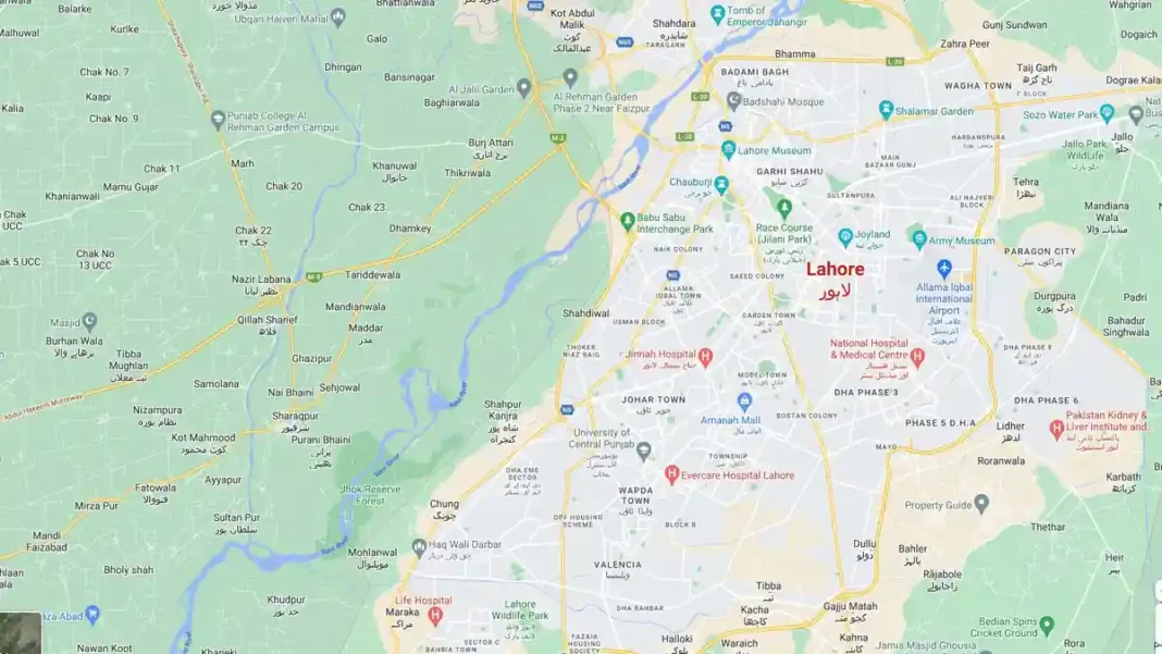
Quick answer: A Pakistan city map shows a single city at street level — roads, neighbourhoods, landmarks, hospitals and transport links. The Lahore map featured here is a good example: it labels areas from DHA and Johar Town to the Walled City, plus hospitals, universities and mosques. Use city maps for navigation, house-hunting, business location scouting and exam questions on urban geography.
In this guide
Reading the Lahore city map
The featured Lahore map reads like the city itself. The Ravi River curls along the west; the M-2 motorway and N-5 run north-south; the Ring Road (L-20) loops the urban core. Historic Lahore sits east — the Badshahi Mosque, Lahore Fort area, Shalimar Garden — while the planned expansions spread south and southwest: DHA phases, Johar Town, Model Town, Valencia, Bahria Town. Hospitals (Jinnah, Evercare, National Hospital), universities (University of Central Punjab, Punjab College campuses) and the Allama Iqbal International Airport are all marked — the landmarks people actually navigate by. Note the bilingual labels: many places carry both English and Urdu names, which is standard on Pakistani city maps.
What city maps show
A proper city map layers five things: the road network (arterials in yellow/orange, streets in white), administrative areas (towns, housing schemes, cantonments), landmarks (mosques, parks, stadiums, museums), services (hospitals, universities, police stations), and transport (bus terminals, railway stations, airports, metro lines where they exist — Lahore’s Orange Line, for instance). The best digital city maps update continuously: new housing schemes appear within months of launch.
Which Pakistani cities have good maps
Coverage follows population and mapping activity. Karachi, Lahore and Islamabad have the deepest coverage on Google Maps and OpenStreetMap — down to individual streets and most businesses. Rawalpindi, Faisalabad, Multan, Peshawar, Quetta, Hyderabad and Sialkot have solid road networks with good landmark coverage. Smaller cities are patchier: main roads and bazaars are mapped, but new housing schemes may lag. For stylised city art rather than navigation, our map clipart guide features a Karachi vector map.
Practical uses
City maps earn their keep in daily life: finding a hospital or university in an unfamiliar city, checking commute routes before renting a house, scouting business locations, and planning deliveries. Students meet them in urban-geography questions — “mark the following on the map of Lahore” is a standard paper pattern. For the country-level context around any city, keep our labelled Pakistan map image and the detailed road map open alongside.
Related Guides
Pakistan city maps: FAQs
Where can I find a detailed map of Lahore?
The street map featured here shows Lahore in detail — neighbourhoods, roads, hospitals and landmarks. For live navigation, search Lahore in Google Maps or OpenStreetMap.
Which Pakistan city has the best online map coverage?
Karachi, Lahore and Islamabad have the deepest coverage on Google Maps and OpenStreetMap, down to street level with most businesses marked.
What is the Orange Line shown near Lahore on some maps?
Lahore’s metro train line — Pakistan’s first metro line, opened in 2020, running from Dera Gujran to Ali Town across the city.
Are there Urdu-language city maps of Pakistan?
Google Maps shows many Lahore and Karachi place names in both English and Urdu. For a country-level Urdu map, see our Pakistan naqsha guide.