Quick Facts
- Location: On the left bank of the Indus River in Diamer district, Gilgit-Baltistan, Pakistan — the gateway where the Karakoram Highway meets the southern end of the northern areas.
- Altitude: Around 1,200 metres (3,900 feet) above sea level at Chilas town, with the surrounding mountains and Babusar Top rising far above it.
- Famous For: Being the first real town of Gilgit-Baltistan on the Karakoram Highway, its ancient rock carvings, its hot dry climate, and its position beneath the Babusar Pass and the great peak of Nanga Parbat.
- Nearest City: Gilgit, roughly 130 kilometres to the northeast on the Karakoram Highway.
- Accessibility: Road access only, via the Karakoram Highway from Islamabad or Gilgit, or via Babusar Top from Naran in summer. The nearest airport is Gilgit, about 3 hours away by road.
- Known Landmarks: Chilas Fort from the 1800s, the Chilas rock carvings, Babusar Top, and the Thak Nallah gorge.
- Best For: Road trippers on the Karakoram Highway, travellers crossing between Kaghan Valley and Gilgit-Baltistan, history and archaeology fans, and anyone who wants a first taste of the north.
Why Visit Chilas Valley
Every great journey north begins somewhere, and for travellers on the Karakoram Highway, that somewhere is Chilas. This is the town where the long road from the plains finally becomes the north: the air turns drier, the mountains close in, the Indus appears beside the road, and the first carved rocks of the ancient Silk Road start showing up on the boulders. Chilas is not a polished resort town — it is something better. It is the real, working gateway to Gilgit-Baltistan, and it has been a crossroads of traders, pilgrims, and armies for thousands of years.
What makes Chilas Valley worth your time, rather than just a fuel stop on the way to Hunza? First, it is the threshold experience. Travellers who pause here get to feel the transition — the moment Pakistan’s north truly begins — instead of racing through it. Second, it holds some of the most important archaeology in the country: the Chilas rock carvings, with more than 50,000 petroglyphs and inscriptions, begin here. Third, it is the southern door to Babusar Top, one of the most spectacular mountain passes in Pakistan, and to the viewpoints of Nanga Parbat, the ninth-highest mountain in the world.
Chilas also has a climate and character all its own. While the rest of the northern areas are famous for cool summers, Chilas is hot and dry — a desert valley in the mountains, where the sun bakes the gorge and the evenings bring relief. It feels exotic even to Pakistanis who have seen the rest of the north. The bazaar is authentic, the people are Shina-speaking with their own traditions, and the old fort on the heights remembers the days when this was a frontier garrison.
This Chilas Valley travel guide is your complete companion: why the valley deserves a stop on your itinerary, the real history of this ancient crossroads, the top things to do, how to reach Chilas from Islamabad, Lahore, and Karachi, the weather through the year, where to stay and eat, and practical tips for making the most of the gateway to the north.
History of Chilas Valley
Chilas has been a place of passage for longer than almost anywhere else in Pakistan. The Indus gorge here formed one of the natural corridors between the Indian subcontinent and Central Asia, and for thousands of years traders, pilgrims, and invaders moved through it. The proof is carved into the rocks themselves: the earliest petroglyphs around Chilas date to between 5000 and 1000 BC, and the Buddhist-era carvings of the 1st to 8th centuries AD show that this valley sat on one of the great Silk Road routes, where monks and merchants left inscriptions in Kharoshthi, Brahmi, and Sogdian. The German ethnologist Karl Jettmar and the Pakistani archaeologist Ahmad Hasan Dani both studied these carvings, with Dani arguing from a Kharoshthi inscription that Chilas once formed part of the ancient Kamboja kingdom.
For centuries, Chilas was also one of the keys to the mountain routes. The old summer route into the northern areas ran from the Kaghan Valley over Babusar Top — a pass the British improved in 1890 to connect Gilgit-Baltistan with British India — and Chilas guarded its southern end. From 1947 to 1978, before the Karakoram Highway was officially opened, Babusar was the prime route into the region. The valley’s strategic importance is written in stone at Chilas Fort, which is believed to date back to the 1800s and served as a British military garrison watching over this frontier.
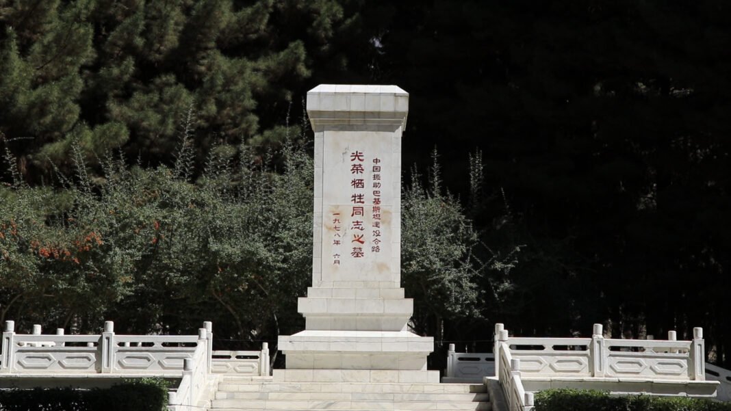
The modern era of Chilas began with the Karakoram Highway. Built with enormous effort and sacrifice through the 1960s and 1970s, the highway turned Chilas from a remote garrison town into the first major stop of the north. Today it is the headquarters of Diamer district, a busy highway town where travellers pause for fuel, food, and rest before pushing on to Gilgit, Hunza, and Skardu — or turn south over Babusar toward Naran and the plains. The valley is changing fast: the Diamer-Bhasha Dam project upstream promises to reshape the whole gorge, which is one more reason to see the Chilas of today while it is still here.
Top Things to Do in Chilas Valley
Explore the ancient rock carvings
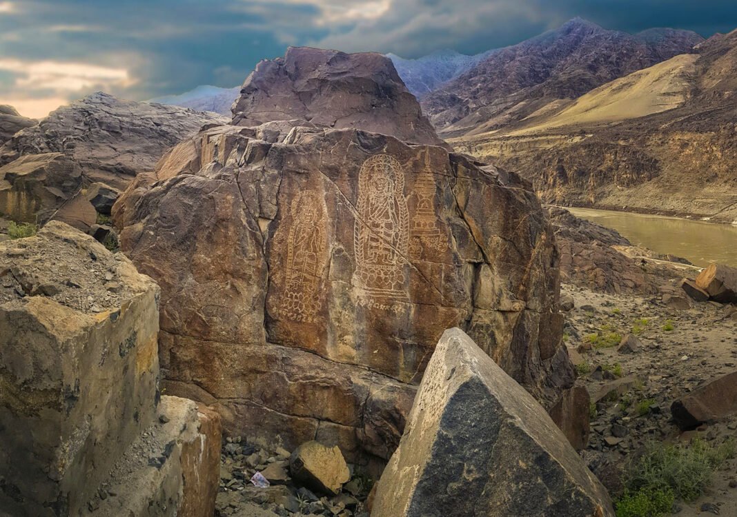
No visit to Chilas is complete without seeing the rock carvings. The Chilas II site, about two kilometres from Chilas Gate on the Karakoram Highway, holds some of the finest Buddhist-era stupa and monk carvings in the region, and the prehistoric hunting scenes and ibex figures are just as moving. Go in the early morning or late afternoon when the low sun brings out the carved lines. Our full Chilas Rock Carvings travel guide covers the sites in detail.
Visit Chilas Fort
The old fort on the heights above the town is believed to date back to the 1800s and served as a British military garrison in the days when Chilas was a frontier outpost. While it is a military area and not open for casual wandering, the fort’s position above the gorge tells the whole strategic story of the valley at a glance. Ask locally about the best viewpoint — the sight of the old walls above the Indus, with the gorge falling away below, is worth the short climb to see.
Drive up to Babusar Top
Babusar Top, at 4,170 metres, is one of the great mountain passes of Pakistan and the crown of any Chilas visit in summer. The road climbs from the hot gorge at Chilas into cool alpine air, past the 45-kilometre Thak Nallah gorge, to the summit where the Kaghan Valley drops away on the far side. The pass is only open from about early June to early November, so time your trip accordingly. Even the drive partway up, to the viewpoints over the gorge, is spectacular.
Walk the Chilas bazaar
The Chilas bazaar is the authentic heart of the town — not a tourist market, but a real working bazaar where Shina-speaking locals shop, eat, and meet. Wander through in the late afternoon, drink chai at a roadside hotel, buy dry fruits and local snacks for the road ahead, and watch the highway traffic of jeeps, trucks, and tour vans that makes Chilas feel like the crossroads it has always been.
Seek out the Nanga Parbat viewpoints
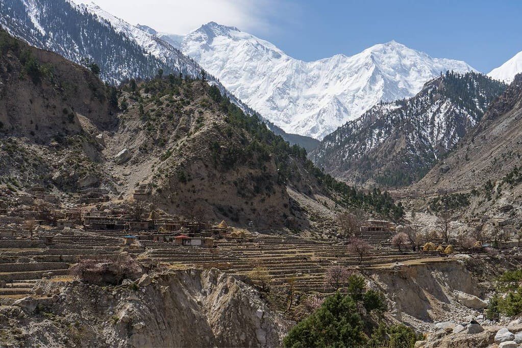
The mighty Nanga Parbat, the ninth-highest mountain in the world, rises to the east of the Chilas gorge, and on clear days its snowy massif dominates the horizon. Local drivers know the best roadside viewpoints. The contrast is unforgettable: the hot, dry gorge at your feet and one of the great Himalayan giants on the skyline. Dawn is the best time, before haze builds up in the valley.
Feel the Indus at the gorge
Chilas sits on the left bank of the Indus, and the river here is at its most powerful — a great grey-green torrent carving through the mountains. Find a safe viewpoint above the water (never climb down to the river’s edge, as the current is deadly) and simply watch it for a while. Few rivers on earth carry the history this one does, from the Indus Valley Civilisation to the carvers of the Buddhist stupas on its banks.
Famous Places In and Around Chilas Valley
Chilas rock carvings (Chilas II) — the great open-air gallery of petroglyphs, 2 km from Chilas Gate. Chilas Fort — the 1800s-era garrison fort above the town. Babusar Top — the 4,170-metre pass to Kaghan Valley, open in summer. Thalpan — carving fields across the Indus. Shatial — the rock-inscription crossroads, about 60 km west on the KKH. Naran and Kaghan Valley — reached over Babusar in summer. Continue your northern journey with our Hunza Valley travel guide or browse the whole collection in Explore Pakistan.
How to Reach Chilas Valley
Chilas is reached by road, and there are two great routes in. The classic all-weather route is the Karakoram Highway from Islamabad: roughly 470 kilometres through Hassan Abdal, Mansehra, Besham, Pattan, Dasu, and Shatial, taking 10 to 12 hours of driving. This is the road the carvings line, and it passes the Shatial inscriptions on the way in. The second route, open only in summer, runs from Islamabad up the Hazara Motorway to Naran, through the Kaghan Valley to Babusar Top at 4,170 metres, and then down the spectacular 45-kilometre Thak Nallah gorge to join the Karakoram Highway about 5 kilometres north of Chilas. The Babusar route is shorter and far more beautiful, but it closes with the first heavy snow, usually by early November, and reopens around June.
From Lahore, add the roughly 375-kilometre motorway journey to Islamabad first — the total to Chilas is around 850 kilometres, so plan 14 to 17 hours and an overnight stop in Mansehra, Naran, or Besham. From Karachi, fly to Islamabad and continue by road; the road journey from Karachi is too long to be enjoyable. You can also fly into Gilgit from Islamabad and drive south to Chilas, about 130 kilometres or 3 hours on the Karakoram Highway.
Public transport is straightforward: NATCO and private coach services run daily between Islamabad (Pirwadhai), Chilas, and Gilgit. Most tourists travel by private car, rented jeep, or tour van, which is the best way to stop at the carving sites and viewpoints along the way. Road conditions on the KKH are generally good but watch for landslide-prone stretches around Dasu after rain.
Route Details
Islamabad to Chilas via KKH (all weather): Islamabad — Hassan Abdal (N-35) — Mansehra — Thakot — Besham — Pattan — Dasu — Shatial — Chilas. Islamabad to Chilas via Babusar (June to November): Islamabad — Hazara Motorway (M-15) — Mansehra — Balakot — Naran — Babusar Top (4,170 m) — Thak Nallah gorge — KKH 5 km north of Chilas. Gilgit to Chilas: straight down the KKH, about 130 km, roughly 3 hours.
Where to Stay in Chilas Valley
Chilas is a highway town, so its accommodation is built for travellers passing through — and it does the job well. Mid-range hotels line the Karakoram Highway and the main bazaar road, offering clean rooms, attached baths, hot water, and on-site restaurants. Family-run guesthouses are plentiful and often the friendliest option; the owners will happily tell you the current state of the Babusar road or which carving site to visit first. Prices are reasonable by northern-areas standards, though they rise in the summer peak season when every jeep and tour van on the KKH seems to stop here.
Because Chilas is an overnight stop rather than a destination resort, most visitors stay just one night. If you want more comfort or a longer stay, the natural alternatives are Naran (via Babusar in summer) or Gilgit (130 km north), both of which offer a wider range of hotels. Adventurous travellers can camp in the side valleys with local permission, but the gorge is very hot in summer, so choose a shaded spot and carry plenty of water. Wherever you stay, book ahead if you are arriving in July or August — the highway rush fills rooms fast.
Where to Eat: Local Foods of Chilas Valley
Eating in Chilas means eating like the highway does. The roadside hotels along the KKH serve the classic northern dhabha spread: daal fry, mixed sabzi, chicken karahi, fresh tandoori roti, rice, and endless cups of strong milky chai. After a long drive, this simple food tastes like a feast. The town’s restaurants also serve barbecued meats in the evening, and the bazaar has fruit vendors, bakeries, and snack shops for stocking up before the next leg of the journey.
The local population is Shina-speaking, and if you are invited into a home you may taste traditional dishes of the region — accept with both hands and genuine thanks, because hospitality is taken seriously here. One practical note: Chilas is a conservative town, so eat and behave with the same modesty you would show anywhere in the area. Carry drinking water on day trips, and in summer keep snacks in the car for the long, hot stretches between towns.
Weather in Chilas Valley
Chilas has one of the most distinctive climates in the northern areas: hot and dry in summer, dry and cold in winter, with very little rain at any time of year. The gorge sits in the rain shadow of the great ranges, so the air is crisp and the skies are clear far more often than not. Summer afternoons can be fiercely hot on the bare rock — the mid-30s Celsius are normal — while winter nights are properly cold. The shoulder seasons are the most comfortable of all.
| Season | Temperature Range | Conditions |
|---|---|---|
| Winter (Dec–Feb) | Around 0–10°C | Dry and cold; clear sunny days, cold nights. The Babusar route is closed, so arrive via the KKH. Quiet and peaceful. |
| Spring (Mar–May) | Around 15–28°C | Warming up nicely; wildflowers in the side valleys. Babusar usually reopens around June. A lovely time to explore. |
| Summer (Jun–Aug) | Around 30–40°C | Hot and dry; the peak travel season. Babusar is open, the bazaar is busy, and the evenings are the best part of the day. |
| Autumn (Sep–Nov) | Around 15–28°C | Cooling, clear, and golden. The crowds thin, the light is beautiful, and Babusar stays open until the first heavy snow. |
Language and Culture of Chilas Valley
The people of the Chilas valley are Shina speakers, with Pashtun settlers adding Pashto to the mix; Urdu is widely spoken and understood, and you will find some English in the bazaar and hotels. Diamer district is culturally conservative, and visitors should dress modestly — shalwar kameez or long trousers and covered shoulders for everyone, with women travellers most comfortable in local-style dress. The old tribal and clan structures still matter here, and respect for elders and local custom goes a long way.
Hospitality is a genuine tradition: offers of tea and food are common, and accepting them graciously is the right response. Always ask before photographing people. At religious sites and in the bazaar, keep behaviour low-key. And at the rock carvings — the valley’s greatest treasure — the cultural rule is absolute: look, photograph, but never touch, chalk, or mark the stones in any way.
Shopping in Chilas Valley
The Chilas bazaar is a real working market, not a tourist strip, and that is exactly why it is worth a walk. Stock up on dry fruits — apricots, almonds, and walnuts brought down from the valleys to the north — along with local honey, woollen caps and shawls, and handicrafts from Gilgit-Baltistan. Prices are honest and haggling is gentle. You will not find shopping malls in Chilas, and there is no need for them; the bazaar covers everything a traveller needs, from snacks for the road to a warm shawl for Babusar Top. For anything fancier, Gilgit’s markets are 3 hours up the road.
Travel Tips for Chilas Valley
Packing Essentials
Pack for two climates in one day: light cotton clothes and sun protection (hat, sunglasses, sunscreen) for the hot gorge, plus a warm layer for Babusar Top or the cold winter nights. Sturdy walking shoes handle the rocky carving sites. Carry a refillable water bottle and more drinking water than you think you need — the dry heat dehydrates fast. A power bank is useful, as long driving days drain phones.
Safety Tips
Chilas is a transit town on a major highway, and the usual road-travel rules apply: drive in daylight where possible, take breaks on the long KKH stretches, and check road conditions after rain, especially around Dasu. Keep away from the Indus riverbank — the current is powerful and the banks are unstable. Check the current security picture for Diamer district before you travel and follow local guidance. Most visitors have a smooth, welcoming trip.
Money and Connectivity
Chilas town has banks and ATMs, but do not rely on a single machine — carry enough cash for fuel, food, and rooms. Mobile coverage from the major networks works in town and along the highway, fading in the deeper gorge sections. Fuel up in Chilas before heading over Babusar or up to Gilgit, and download offline maps in advance.
Best Time to Visit Chilas Valley
Spring (March–May)
A beautiful, underrated season. The heat has not yet arrived, the skies are clear, and the valley is at its most comfortable. Babusar usually opens around June, so late spring travellers can sometimes catch the first crossings of the season.
Summer (June–September)
The classic season and the busiest. Babusar Top is open, the KKH is in full flow, and Chilas buzzes with travellers heading in every direction. It is hot in the gorge, but the high passes are glorious. Book rooms ahead, travel early in the day, and rest in the afternoons.
Autumn (September–November)
Many seasoned travellers call this the best season: the heat breaks, the crowds thin, the light turns golden, and Babusar stays open until the first heavy snow, usually into October or early November. Ideal for photography and unhurried exploring.
Winter (December–February)
Cold, quiet, and starkly beautiful. Only the KKH route is open. This is the season for travellers who want the gateway to the north entirely to themselves, with the Indus gorge at its most dramatic.
Final Thoughts
Chilas Valley will never be the polished postcard of the north, and that is precisely its charm. It is the threshold — the place where the plains end and the mountains begin, where five-thousand-year-old carvings sit beside a modern highway, and where every traveller heading to Hunza or Skardu passes through the same gorge that Silk Road pilgrims walked fifteen centuries ago. Give it more than a fuel stop. Walk the bazaar, see the carvings, climb toward Babusar, and feel the north begin.
Come in spring or autumn for the kindest weather, in summer for the full buzzing highway life, and always with respect for the conservative culture and the ancient stones. Chilas rewards the traveller who slows down — and it sends everyone onward, up the Karakoram Highway, with the journey properly begun.
FAQs
Where is Chilas Valley located? Chilas is on the left bank of the Indus River in Diamer district, Gilgit-Baltistan — the first major town of the northern areas on the Karakoram Highway, about 130 km south of Gilgit.
What is the best time to visit Chilas Valley? Mid-June to early September is the peak season with all routes open, but spring (March–May) and autumn (September–October) offer the most comfortable weather and fewer crowds.
How do I reach Chilas Valley? By road: the Karakoram Highway from Islamabad (roughly 470 km, 10–12 hours) all year, or via Babusar Top from Naran in summer (June–November). The nearest airport is Gilgit, 130 km away.
Is Chilas Valley safe for tourists? Yes, with normal precautions. Travel in daylight, check road conditions after rain, keep away from the riverbank, and check the current security situation for Diamer district before you go.
Is Chilas Valley suitable for families? Yes. The town, bazaar, and main carving sites are easily accessible, and the Babusar drive is a hit with children. Carry water and sun protection in summer.
Where can I stay in Chilas Valley? Chilas town has mid-range highway hotels, guesthouses, and family-run lodges. Book ahead in summer. For more choice, Naran and Gilgit are the nearest bigger bases.
What food is available in Chilas? Highway dhabas serve daal, sabzi, chicken karahi, fresh roti, rice, and chai; the bazaar has dry fruits, snacks, and bakeries.
Can I see Nanga Parbat from Chilas? On clear days, yes — the great peak rises to the east of the gorge, and local drivers know the best roadside viewpoints. Dawn offers the clearest views.