Quick Facts
- Location: Northern end of the Kaghan Valley, on the border of Khyber Pakhtunkhwa and Gilgit-Baltistan
- Altitude: 13,691 feet (4,173 metres) above sea level — the highest point in the Kaghan Valley reachable by road
- Famous For: One of Pakistan’s highest driveable mountain passes; 360-degree views of the Karakoram and Himalayan foothills; the gateway from Kaghan to Gilgit-Baltistan
- Nearest City: Naran (about 65-70 km south); Chilas on the Karakoram Highway to the north
- Accessibility: Paved N-15 road from Naran via Batakundi and Jalkhad; open roughly mid-June to October; closed in winter
- Known Landmarks: The pass summit with its viewpoint, Lulusar Lake en route, Jalkhad meadows, views of Malika Parbat and Rakaposhi
- Best For: Road-trippers, photographers, adventure travelers, families on a Naran-Kaghan tour, bikers
Why Visit Babusar Top
There are mountain passes you drive through, and there are mountain passes you remember for the rest of your life. Babusar Top is the second kind. At 13,691 feet, it is the highest point of the Kaghan Valley and one of the highest paved passes in Pakistan that an ordinary car can reach. The road climbs out of Naran through Batakundi and Jalkhad — past the Kunhar River, waterfalls, and the mirror-still Lulusar Lake — and then keeps climbing through alpine meadows until the air thins, the temperature drops, and the whole roof of northern Pakistan opens up around you. This babusar top travel guide is for everyone who wants to do that drive properly.
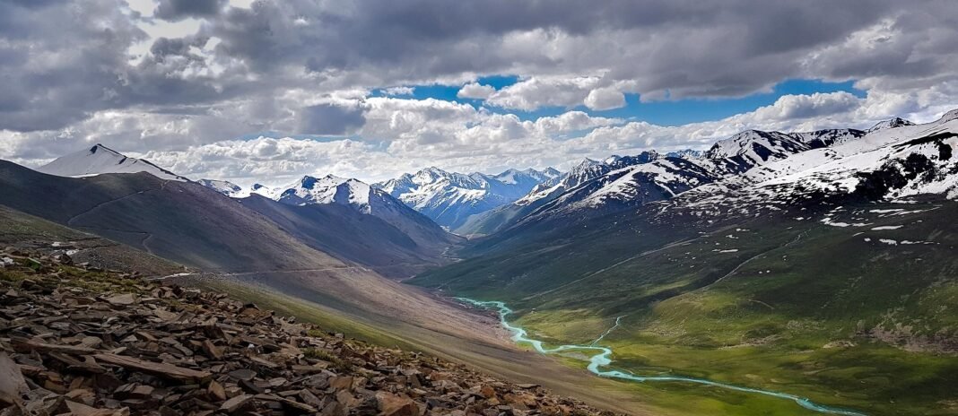
The summit itself is an experience. From the top you can see Rakaposhi rising to the north, the great pyramid of Malika Parbat — the highest peak of the Kaghan Valley — and Toshe Ri (Sarwali Peak) among the surrounding giants. Prayer flags snap in a wind that never really stops, small restaurants serve hot chai to shivering tourists, and everyone takes the same photograph next to the Babusar Top signboard. It is touristy, yes — but the setting earns it. Few places in Pakistan give you this much grandeur for the price of a day trip from Naran.
Babusar is also a working mountain pass, not just a viewpoint. It is the summer shortcut between Khyber Pakhtunkhwa and Gilgit-Baltistan: cross it and you descend to Chilas and the Karakoram Highway, the road to Gilgit, Hunza, and Skardu. Travelers heading north often plan their whole route around it, because the Babusar road saves hours compared with the longer lowland route via Besham. Even if you turn back to Naran, driving the pass is the climax of any Kaghan Valley trip.
Timing matters more here than at almost any other destination in this series. The pass is buried in snow from roughly November to May and typically reopens in June; the season is short, the weather changes fast, and altitude demands respect. Done right — in July, August, or September, with an early start and warm clothes — it is one of the great drives of South Asia.
History of Babusar Top
The pass is older than its road. Local tradition holds that the Mughal emperor Babur used this route in the 16th century during his campaigns toward the subcontinent, and the name “Babusar” is popularly linked to him — though, as with many mountain legends, the etymology is tradition rather than documented history. What is documented is that for centuries the crossing was a rough track used by herders, traders, and local tribes moving between the Kaghan Valley and the Diamer region.
The modern history of the pass begins in 1890, when the British built a shorter track across Babusar that directly connected Gilgit with British India. The colonial administration needed reliable access to the Gilgit Agency, and the Babusar route offered a far more direct line than the alternatives. The track was rough and seasonal, but it established Babusar as a strategic crossing — a role it has never lost.
After independence, the track was gradually improved into the paved N-15, the Naran-Babusar-Chilas road that tourists drive today. The improvement transformed the region’s tourism: Naran, once a remote valley town, became one of Pakistan’s most visited hill stations, and Babusar Top became the signature excursion of every Naran trip. The pass now carries thousands of vehicles each summer day in peak season, serving simultaneously as a tourist attraction and as the vital summer link between Khyber Pakhtunkhwa and Gilgit-Baltistan via Chilas and the Karakoram Highway.
The pass’s fame has a practical edge that travelers still feel. Because it is the highest paved point for miles, weather systems hit it first; the road is typically only usable between about 6 AM and 6 PM in season, and authorities close it at the first sign of dangerous conditions. Snowfall can begin as early as late October, and the pass has been shut by early snow and landslides in recent years — a reminder that this beautiful road is still a serious mountain crossing.
Top Things to Do in Babusar Top
Drive the Naran-Babusar Road
The drive is the destination. The 65 to 70 km from Naran takes about two and a half to three hours each way, climbing through Batakundi village, the wide Jalkhad meadows, and the final switchbacks to the summit. The Kunhar River runs alongside much of the route, and every bend offers a new composition of meadows, streams, and peaks. Leave Naran early — traffic builds up through the day, especially near Lulusar Lake — and drive with an experienced hand on the wheel. The road is paved and in generally good condition, but it is narrow, winding, and unforgiving of carelessness.
Stand at the 13,691-Foot Summit
At the top, get out, walk slowly, and take in the panorama. The air is thin — around 40 percent less oxygen than at sea level — so avoid running or exertion for the first few minutes, drink water, and let your body adjust. On a clear day the views stretch from Malika Parbat on the Kaghan side to Rakaposhi far to the north. The summit has small restaurants and tea stalls, souvenir sellers, and the famous signboard. Spend thirty to forty-five minutes; longer exposure to the cold wind and altitude is unnecessary.
Photograph Lulusar Lake
About an hour out of Naran, Lulusar Lake sits beside the road like a sheet of green glass, ringed by mountains. It is one of the most photographed lakes in the Kaghan Valley and a mandatory stop. Note that fishing, hunting, and boating are not allowed here — it is a protected, pristine lake, and visitors are expected to keep it that way. Morning light is best, before the day-trip crowds arrive.
Walk the Jalkhad Meadows
Before the final climb, the road crosses the broad, rolling Jalkhad meadows — summer grazing grounds dotted with the tents and herds of Gujjar herders. Stop for a short walk among the wildflowers (in July and August), photograph the streams braiding across the grass, and buy fresh dairy or a cup of chai if herders are selling. It is the gentlest, greenest stretch of the whole route.
Descend Toward Chilas (Optional)
If your itinerary continues north, keep driving over the summit and down to Chilas, where the road meets the Karakoram Highway at Thak Nala. The descent is dramatic — the landscape shifts from alpine green to the stark, rocky gorges of Diamer, and Chilas itself is famously hot even in summer. Most Naran-based visitors turn back at the top, but through-travelers to Gilgit, Hunza, or Skardu cross here as a matter of course.
Famous Places In and Around Babusar Top
- Lulusar Lake — the stunning alpine lake on the Naran-Babusar road; no boating or fishing allowed.
- Jalkhad Meadows — wide summer pastures with streams and Gujjar encampments.
- Batakundi Village — the last village of note before the high meadows; waterfalls nearby.
- Chilas — the hot, dramatic town on the Karakoram Highway at the northern foot of the pass.
- Naran Bazaar — the lively tourist town at the southern end of the route; base for the excursion.
- Lake Saif-ul-Malook — near Naran (jeep track from town); the classic combination with a Babusar day trip.
How to Reach Babusar Top
Every journey to Babusar Top goes through Naran. From Islamabad, drive the Hazara Motorway to Mansehra, then continue on the Mansehra-Naran-Jalkhad road (N-15) through Balakot and Kaghan to Naran — a long day’s drive through the mountains, so most travelers overnight in Naran before attempting the top. From Lahore, the route runs via the M-2 to Islamabad and then the same mountain road; plan for a very long day or split the journey at Mansehra or Balakot. From Karachi, fly to Islamabad and continue by road, or fly to Gilgit/Skardu and approach from the northern side via Chilas if the pass is open.
The final leg — Naran to Babusar Top — is about 65 to 70 km and takes two and a half to three hours by car or jeep. The road is open only in season (roughly mid-June to October) and typically only between about 6 AM and 6 PM; authorities stop vehicles outside those hours. In Naran, jeeps and private cars for the excursion are easily hired from the bazaar; agree on the price, the stops (Lulusar, Jalkhad), and the return time before leaving. Public vans also run the route in peak season.
Route Details
- Islamabad to Naran: Hazara Motorway to Mansehra, then N-15 via Balakot, Kaghan, and Kaghan Valley towns to Naran. A full day’s mountain drive; overnight in Naran.
- Naran to Babusar Top: N-15 north via Batakundi, Jalkhad, and Lulusar Lake to the summit — 65-70 km, 2.5 to 3 hours. Leave by 7 AM to beat traffic and afternoon weather.
- Babusar Top to Chilas: Continue north down the pass to Thak Nala and the Karakoram Highway at Chilas — the through-route to Gilgit, Hunza, and Skardu.
- Timing rule: Plan to be off the summit by mid-afternoon. Weather deteriorates quickly after 2 PM, and the road closes to traffic around 6 PM.
Where to Stay in Babusar Top
There is no hotel at the summit — Babusar Top is a day excursion, and everyone sleeps lower down. Naran is the natural base, with Pakistan’s densest concentration of mountain tourism accommodation: luxury hotels, mid-range hotels, guesthouses, and camps, spread along the bazaar road and the river. Book well ahead for July, August, and public holidays, when Naran fills completely; in the shoulder season (June, September, October) you will find rooms more easily and at better rates.
Batakundi, partway up the Babusar road, has a smaller cluster of hotels and camps for travelers who want to start the climb earlier or escape Naran’s crowds. On the northern side, Chilas has basic hotels serving Karakoram Highway travelers. For through-travelers continuing to Hunza or Skardu, the usual pattern is Naran → Babusar → Chilas/Gilgit in a single long day. For broader northern-areas planning, see the Hunza Valley guide and the Explore Pakistan section.
Where to Eat: Local Foods of Babusar Top
At the summit, small restaurants and dhabas serve the high-altitude staples: hot chai, pakoras, boiled eggs, instant noodles, and simple daal-chawal and chicken dishes. Everything tastes better at 13,691 feet, and the hot tea is genuinely restorative in the wind. Prices are higher than in the plains — every ingredient is trucked up the mountain — so eat your main meals in Naran.
Naran’s bazaar is the real food stop: dozens of restaurants serve trout (the Kaghan Valley’s famous fish, farmed locally and served fried or grilled), barbecue, karahi, Chinese, and fast food. The dhabas along the Babusar road at Batakundi and Jalkhad offer simpler fare — daal, sabzi, omelets, and parathas — at reasonable prices. Carry snacks and water for the drive itself, and avoid tap water anywhere on the route; use bottled or boiled water.
Weather in Babusar Top
Babusar Top has true high-mountain weather: cold even in summer, violent in the shoulder seasons, and impassable in winter. Temperatures can swing 15 degrees in an hour when cloud rolls in, and wind chill makes it feel colder than the thermometer says. Dress for winter whatever the month.
| Season | Temperature Range | Conditions |
|---|---|---|
| Winter (Dec-Mar) | Down to -20°C | Pass buried in snow and closed to all traffic. |
| Spring (Apr-May) | 0-10°C | Road still closed; snow clearing usually begins in May. Reopening typically in June. |
| Summer (Jun-Sep) | 5-15°C | The season. Cool, bright days; sudden afternoon cloud and rain possible. Strong sun at altitude. |
| Autumn (Oct-Nov) | -5 to 5°C | Beautiful clear days early in October; snowfall can close the road by late October. |
Language and Culture of Babusar Top
The Kaghan Valley is home to Gujjar communities, and you will hear Gojri and Hindko in the villages and meadows along the road, alongside Urdu, which every driver, hotelier, and shopkeeper speaks. The summer meadows belong to the herders who bring their livestock up from the lowlands — a centuries-old transhumance pattern that the tourist road now threads through.
Culture here is mountain-conservative and deeply hospitable. Dress modestly and warmly (which the weather enforces anyway), ask before photographing herders and their families, and accept offered chai when you can — refusing hospitality is poor manners. Bargain fairly with jeep drivers and vendors; the season is short and this is their livelihood. Keep the meadows and the lakeshore clean — Lulusar’s protection depends on visitors.
Shopping in Babusar Top
Shopping at the summit is limited to souvenir stalls: woolen caps, shawls, keychains, and the usual mountain-trinket selection. Prices reflect the altitude — buy in Naran instead, where the bazaar has a far wider choice of dry fruits (especially apricots and almonds from Hunza and Gilgit-Baltistan), woolens, gemstones, and handicrafts.
The worthwhile purchases of the region are natural: dried apricots, apricot oil, walnuts, and honey from the northern valleys, all sold in Naran’s shops. If you are continuing over the pass to Gilgit-Baltistan, save serious souvenir hunting for Hunza’s or Gilgit’s bazaars, which have the best selection in the north.
Travel Tips for Babusar Top
Packing Essentials
Pack for winter in every month: a warm jacket, fleece, gloves, a woolen cap, and sunglasses (the high-altitude sun is fierce). Wear sturdy closed shoes — the summit is rocky and cold. Carry water, snacks, sunscreen, any personal medication, and a power bank; there is no fuel or ATM beyond Naran until Chilas.
Safety Tips
Altitude is the main risk: walk slowly at the summit, do not run or exert yourself, and descend if you feel dizzy or nauseous. Heart patients and people with breathing difficulties should stay in their vehicle at the top or skip the summit. On the road, use an experienced driver, never drive at night, avoid the pass in rain (landslide risk), and keep windows closed against dust. Fuel up fully in Naran — there is no reliable fuel on the pass.
Money & Connectivity
Carry all the cash you will need — there are no ATMs on the Babusar road. Naran has ATMs (which can run dry in peak season, so withdraw earlier in Mansehra or Balakot as backup). Mobile signals fade beyond Jalkhad; expect little or no coverage at the summit. Download offline maps, inform your hotel of your plans, and travel in daylight only.
Best Time to Visit Babusar Top
July to August — Peak Season
The classic window: the road is reliably open, the meadows are green, Lulusar is at its bluest, and every facility is running. It is also the busiest — expect traffic, crowds at the summit, and the highest hotel rates in Naran. Book everything ahead.
June and September — Best Balance
June brings the excitement of the freshly opened road (confirm opening dates locally, as snow can delay it); September brings thinner crowds, clear air, and the first autumn colors in the valley. Both months offer the Babusar experience with fewer compromises than peak season.
Early October — Last Chance
The first week or two of October can be magical — empty roads, crystalline views — but the season can end any day with the first heavy snow. Check the road status daily and have a backup plan via the Besham route if you must travel north.
November to May — Closed
The pass is shut under snow. Do not plan a Babusar trip in these months; the Kaghan Valley below Naran is still visitable in early winter, but the top is out of reach until summer.
Final Thoughts
Babusar Top is the rare tourist attraction that fully delivers on its reputation. The numbers — 13,691 feet, 65 kilometres of climbing road, a summit you can drive to — sound like brochure copy until you are standing in the wind at the top, looking from Malika Parbat to Rakaposhi, with the whole Kaghan Valley spread out below. An honest babusar top travel guide must add the cautions: the altitude is real, the weather is fickle, the season is short, and the crowds in August are intense. Plan around those facts and the pass rewards you completely.
Drive it early, dress warm, respect the mountain, and give the road the full day it deserves — Lulusar in the morning light, Jalkhad’s meadows at midday, the summit before the afternoon cloud builds. Whether you turn back to Naran or press on over the top toward Chilas and the Karakoram Highway, you will have driven one of the great mountain roads of Pakistan.
FAQs
Where is Babusar Top located?
Babusar Top is at the northern end of the Kaghan Valley in Mansehra district, Khyber Pakhtunkhwa, on the border with Gilgit-Baltistan. It lies about 65-70 km north of Naran on the N-15 road to Chilas.
What is the height of Babusar Top?
Babusar Top stands at 13,691 feet (4,173 metres) above sea level, making it the highest point in the Kaghan Valley reachable by road and one of Pakistan’s highest driveable passes.
When is Babusar Top open?
The pass is typically open from mid-June to October, depending on snowfall. It is closed through the winter. In season, the road is generally usable between about 6 AM and 6 PM.
How do I reach Babusar Top from Islamabad?
Drive the Hazara Motorway to Mansehra, then the N-15 through Balakot and Kaghan to Naran (a full day’s drive), overnight in Naran, and drive the 65-70 km to the summit the next morning (2.5 to 3 hours).
Is Babusar Top safe to visit?
Yes, in season and with precautions. Walk slowly at the summit because of the thin air, use an experienced driver, never drive at night or in rain, and be off the top by mid-afternoon before weather builds.
What is the best time to visit Babusar Top?
July and August offer the most reliable weather; June and September give you the experience with fewer crowds. Early October is beautiful but risky, as snow can close the road at any time.
Where can I stay near Babusar Top?
Naran is the main base, with hotels and guesthouses for every budget — book ahead in peak season. Batakundi has smaller options partway up, and Chilas serves travelers crossing to the northern side.
What should I eat on a Babusar Top trip?
Eat your main meals in Naran — try the local trout, barbecue, and karahi. At the summit, small stalls serve hot chai, pakoras, and simple dishes at mountain prices. Carry water and snacks for the drive.