Quick Facts
- Location: Bagrot Valley, Gilgit District, Gilgit-Baltistan, Pakistan, in the Karakoram range
- Altitude: 6,143 m (20,154 ft), around 6,138 m by some local measurements
- Famous For: Its striking pyramid shape visible from Gilgit, and as the landmark peak of the Bagrot Valley
- Nearest City: Gilgit, around 29 km west of the peak and 38 km by road from the Bagrot Valley entrance
- Accessibility: The peak is viewed from Bagrot Valley, reached by a 2+ hour drive from Gilgit; the valley road is mostly metalled
- Known Landmarks: Bagrot Valley, Gargo meadows, Doboi Glacier, and neighbouring giants Rakaposhi (7,788 m) and Diran (7,266 m)
- Best For: Peak viewing, valley trekking, photography, camping, and cultural travel
Why Visit Bilchar Dobani (Dobani Peak)
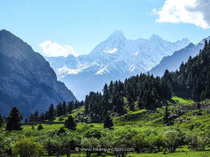
Most travellers in Gilgit look east on a clear morning and see it: a great white pyramid rising alone above the ridges, separate from the famous wall of Rakaposhi and Diran. That is Bilchar Dobani, the Dobani Peak, a 6,143-metre giant that stands like a sentinel over the Bagrot Valley. It is not one of Pakistan’s famous eight-thousanders, and that is exactly its charm. This bilchar dobani travel guide is for travellers who want the Karakoram’s drama without the expedition crowds, because the peak is best experienced from one of Gilgit-Baltistan’s least-visited valleys.
Bagrot Valley itself is the real discovery here. Tucked between the Gilgit River and the high Karakoram, the valley runs from around 2,500 metres up to 4,500 metres, a green world of terraced fields, orchards, and alpine pastures, ringed by glaciers and peaks over 6,000 metres. Doboi, Gargo, Yunay, and other glaciers pour down from the heights, and the Bagrot River runs the length of the valley past villages like Farfu, Jalalabad, and Oshikhandass before joining the Gilgit River. Travellers who ask where is Bilchar Dobani will find that the answer is a whole valley, not just a mountain.
The valley rewards slow travel. Trekkers can walk up to the Gargo meadows, a vast alpine pasture backed by glaciers and the Dobani massif itself, camp beside shepherd huts, and watch the evening light turn the peak gold. The valley is part of the buffer zone of the Central Karakoram National Park, and its slopes hold ibex, markhor, and occasionally snow leopards. The people are known for warmth and hospitality, and the valley’s organic fruit, especially apricots and cherries in season, is famous across Gilgit.
For mountaineers, Dobani has its own history. It was first climbed in 1979 by a Japanese expedition, and it remains a serious but achievable objective for experienced climbers, far less crowded than the famous peaks of the region. For everyone else, it is one of the great viewpoint mountains of the Karakoram: a peak you can admire from a meadow with a cup of tea, which is sometimes the best way to meet a mountain.
History of Bilchar Dobani (Dobani Peak)
The peak sits in a valley with deep roots. According to local accounts recorded by researchers, the first settler of the Bagrot Valley was a man named Cholok (also spelled Chalok), and the families descended from him and from early ancestors with names like Tais, Raki, Dodo, and Shoro form much of the valley’s population today. The valley has long been a cradle of mountain culture, and its people have preserved their traditions, language, and festivals through centuries of relative isolation.
In mountaineering history, Bilchar Dobani entered the record on 9 June 1979, when Japanese climbers Isao Ikeuchi and Masaru Hashimoto made the first ascent via the west face and the northern ridge. The peak stands as an isolated subrange of the Karakoram, southeast of the Rakaposhi subrange and southwest of the Haramosh mountains, and its position, 29 kilometres east of Gilgit city, made it one of the more accessible 6,000-metre peaks for early expeditions. Later parties have climbed it by various routes, but it has never become a commercial peak, and it keeps the quiet character of a mountaineer’s mountain.
The valley around it has its own modern history. Bagrot was long considered difficult to reach even for local people because of the poor road, but in recent years most of the road has been metalled, and even a small car can now travel much of it. The valley forms part of the buffer zone of the Central Karakoram National Park, which was officially established in the 1990s, and it has become a model region for community-based conservation. Travellers today find a valley that is opening up but has not lost its traditional farming life, where barley, maize, potatoes, and wheat are still grown on terraces and livestock graze the high pastures in summer.
Top Things to Do in Bilchar Dobani (Dobani Peak)
View the Peak from Bagrot Valley
The essential experience is simply to look at the mountain. From viewpoints around the upper valley, especially near Gasunar and the Gargo area, Bilchar Dobani rises in a clean pyramid, often clearest in the early morning before clouds build. The peak is also visible from Jutial near Gilgit on clear days. Bring binoculars and a camera with a zoom lens, and plan your viewing for sunrise or sunset when the snow glows pink and gold.
Trek to Gargo Meadows
The classic valley trek climbs from the road head through forest and glacier moraine to the Gargo meadows, a vast alpine pasture with lanky alpine trees on one side, a glacier on the other, and the Dobani massif rising behind. The route passes the Gargo glacier, where you can hear the drumming sound of melting ice, and shepherds’ huts where you may be offered fresh milk. It is a full-day walk from the road end, and camping at Gargo under the stars with the peak overhead is one of the great free experiences of Gilgit-Baltistan. Go with a local guide, as the glacier crossing needs care.
Camping and Stargazing
The upper valley has superb camping, from the meadows near Gargo to pastures used by shepherds in summer. Nights at 3,500 to 4,000 metres are cold but the skies are extraordinarily clear, far from city lights. Bring a warm sleeping bag and all your own gear, since there are no commercial campsites. Always camp with permission near settlements and keep a clean camp.
Photography
Bagrot is a photographer’s valley: the peak itself, the glaciers, terraced fields, orchards in blossom or fruit, and the daily life of a traditional mountain valley. The contrast between the green valley floor and the white wall of peaks is at its best in the soft light of morning and evening. Ask permission before photographing people, and respect the privacy of homes and farms.
Explore the Villages
The valley’s villages, including Farfu (the principal locality), Bulche, Datuchi, Hopay, and Sinaker, offer a look at traditional mountain life. Walk the irrigation channels, visit the orchards, and accept the tea you will inevitably be offered. The permanent settlements lie between 1,700 and 2,400 metres, and in summer many families move to high pastures. A local guide can arrange respectful village visits.
Famous Places In and Around Bilchar Dobani (Dobani Peak)
- Bagrot Valley – The green valley at the foot of the peak, 38 km from Gilgit, with villages, orchards, and glaciers.
- Gargo Meadows – Vast alpine pastures below the Dobani massif, the classic trekking and camping destination.
- Doboi Glacier – One of the valley’s major glaciers, surrounding the peak’s flanks.
- Rakaposhi (7,788 m) – The famous giant visible from the valley, with its glacier used by Gilgit for ice.
- Diran Peak (7,266 m) – Another great neighbour rising over the valley’s northern side.
- Miar Peak (6,824 m) – A striking 6,000er in the valley’s crown of peaks.
- Gasunar Valley – The last valley at the road’s end, with views of Rakaposhi and a jumping-off point for treks toward Haramosh.
How to Reach Bilchar Dobani (Dobani Peak)
The journey starts in Gilgit, the capital of Gilgit-Baltistan. From Islamabad, Gilgit is reached by the Karakoram Highway, a road journey of around 600 kilometres that takes 14 to 18 hours, usually with a night stop, or by the roughly one-hour flight from Islamabad to Gilgit Airport, which is weather-dependent. From Lahore, travellers typically drive or fly to Islamabad first; the road distance from Lahore to Gilgit is around 850 kilometres or more. From Karachi, the practical route is to fly to Islamabad and continue by air or road to Gilgit.
The nearest airport is Gilgit Airport, with regular flights from Islamabad in good weather. From Gilgit city, Bagrot Valley lies about 38 kilometres to the east, and the drive takes two hours or more. Around two-thirds of the road is now metalled, and the rest is in fair condition, passable by a small car in dry weather, though a jeep or high-clearance vehicle is more comfortable. The road follows the Bagrot River upstream through the villages to Gasunar, the last settlement.
Road conditions are best from May to October. In winter the upper valley can be cut off by snow. Transport options include hiring a private jeep or car in Gilgit, which is the most convenient, or taking local vans part of the way and arranging onward transport. There is no public transport deep into the valley, so for the upper villages and trekking trailheads, a hired vehicle or a local guide with transport is the practical choice. If you are wondering how to reach Bilchar Dobani for a climb, note that mountaineering expeditions need permits and must go through a registered tour operator.
Route Details
- Travel from Islamabad to Gilgit by air (about 1 hour) or by road on the Karakoram Highway (14-18 hours).
- From Gilgit city, drive east toward Bagrot Valley, about 38 km, 2+ hours.
- Follow the valley road upstream along the Bagrot River through Farfu, Jalalabad, and Oshikhandass.
- Continue to Gasunar valley, the last settlement and the end of the road.
- For Gargo meadows and peak viewpoints, trek onward from the road head with a local guide.
Where to Stay in Bilchar Dobani (Dobani Peak)
Bagrot Valley is not a hotel destination, and that is part of its appeal. Accommodation is in village guesthouses and homestays, which are simple but welcoming, offering a bed, home-cooked food, and a genuine look at valley life. These are best arranged through a local contact or guide in Gilgit, since there is no online booking for most of them. For trekkers heading to Gargo and the high pastures, camping in your own tents is the standard option.
Gilgit city, the base for the trip, has the full range. Luxury hotels and resorts sit along the main roads and the river, mid-range hotels cluster in the city centre around the bazaar, and budget guesthouses and hostels serve backpackers. Staying in Gilgit and doing Bagrot as a long day trip or an overnight trip is the most common pattern. In the May to October season, Gilgit’s better hotels fill up, so book ahead. If you camp in the valley, bring a sleeping bag warm enough for nights that can drop near freezing even in summer.
Where to Eat: Local Foods of Bilchar Dobani (Dobani Peak)
Bagrot’s food is mountain food, built on what the valley grows: barley, wheat, maize, and potatoes. Expect fresh flatbreads baked daily, hearty grain dishes, potatoes cooked in local style, and dairy products from the valley’s livestock, including fresh milk, yoghurt, and butter. In summer the valley’s orchards produce apricots, cherries, and other fruit, and dried apricots are a year-round staple and the classic souvenir. Meals in village homestays are simple, generous, and cooked over wood fires.
In Gilgit city the choice widens. The bazaar area has restaurants serving local Gilgiti dishes, Pakistani food, Chinese, and barbecue, plus bakeries, tea houses, and fresh juice shops. A simple local meal is budget-friendly, while hotel restaurants charge more. If you trek to Gargo, carry your own food and a stove or arrange meals through your guide, since there are no restaurants beyond the villages. Drink boiled or bottled water in the valley.
Weather in Bilchar Dobani (Dobani Peak)
Bagrot Valley has a classic Karakoram mountain climate that changes dramatically with altitude. The valley floor between 2,500 and 4,500 metres is pleasant in summer, with warm days and cool nights, while the high pastures near 4,000 metres stay chilly even in July. Gilgit city, at around 1,500 metres, is hot in summer with daytime highs in the mid-20s to mid-30s Celsius. Winter is severe: Gilgit’s nights drop well below freezing, and the upper valley is buried in snow and largely inaccessible. Spring brings blossom to the orchards, and autumn brings the famous golden colours of the poplars and apricot trees. Rain is scarce; most precipitation falls as winter snow.
| Season | Temperature Range | Conditions |
|---|---|---|
| Winter (Dec-Feb) | Around -10°C to 5°C in Gilgit; far below freezing in the upper valley | Snowbound upper valley; valley road may be blocked |
| Spring (Mar-May) | Around 5°C to 20°C in Gilgit; cool in the valley | Blossom season in orchards; melting snow, streams full |
| Summer (Jun-Aug) | Around 15°C to 30°C+ in Gilgit; 10°C to 22°C in the mid valley | Best season for the valley and treks; long clear days |
| Autumn (Sep-Nov) | Around 0°C to 20°C in Gilgit; cold nights in the valley | Golden autumn colours; clear views of the peak; season ends with snow |
Language and Culture of Bilchar Dobani (Dobani Peak)
The language of Bagrot Valley is Shina, the main language of the Gilgit region, and most people also speak Urdu. English is understood by guides and those working in tourism. The valley’s people are predominantly Muslim, and the culture is conservative and deeply hospitable. Guests are treated with great honour, and refusing offered tea is considered impolite, so accept it graciously.
For visitors, modest dress is important, for both men and women. Ask permission before photographing people, homes, or farms. The valley has preserved its traditions more completely than many places in the region, so show respect for local customs, avoid public displays of affection, and keep noise down in villages. If you visit during farming seasons, do not walk through crops; stick to paths. The shepherds you meet in the high pastures are often happy to share milk or yoghurt; accepting it with thanks is the right response.
Shopping in Bilchar Dobani (Dobani Peak)
Bagrot Valley itself is not a shopping destination, but it produces things worth buying. The valley is known for organic fruit, especially dried apricots, which you can buy directly from villagers in season, along with apricot oil and nuts. Handmade woollen items such as shawls, caps, and socks are made in the valley and in Gilgit. Buying directly from producers supports the local economy.
For a wider choice, Gilgit’s bazaar is the place: dry fruits, traditional caps, woollen shawls, gemstones, and everyday supplies. There are no shopping malls in or near Bagrot Valley; Gilgit has regular markets and small commercial centres. Bargain politely in the bazaar, and check the quality of dried fruit before buying in bulk.
Travel Tips for Bilchar Dobani (Dobani Peak)
Packing Essentials
Pack layers for big temperature swings: warm jacket, fleece, rain shell, sun hat, and sturdy walking shoes or trekking boots. The sun at altitude is fierce, so bring high-SPF sunscreen, sunglasses, and lip balm. If you plan to camp at Gargo or higher, bring a tent, a sleeping bag rated below freezing, a stove, and all your food. A headlamp, basic first-aid kit, and water purification are essential for the upper valley.
Safety Tips
Bagrot is a safe valley for travellers, and crime against tourists is rare. The real risks are mountain risks: do not cross glaciers without a local guide, watch the weather, and turn back if conditions worsen. The valley road has narrow sections, so hire an experienced local driver. Altitude is moderate in the villages but real on the high pastures, so ascend gradually and drink plenty of water. Inform your hotel or a contact in Gilgit of your plans before heading up the valley.
Money & Connectivity
Carry enough cash in Pakistani rupees for the whole valley trip; there are no ATMs in Bagrot Valley, and the nearest reliable ATMs are in Gilgit. Mobile coverage in the valley is patchy. The local operator SCO (Scom) generally has the best signal in Gilgit-Baltistan, with Jazz and Telenor working in Gilgit city and some villages. Expect little or no signal in the upper valley and on the treks. Download offline maps before you go.
Best Time to Visit Bilchar Dobani (Dobani Peak)
Summer (June to August)
The best season for the valley. The road is fully open, the high pastures are green, the Gargo trek is accessible, and the peak views are at their clearest in the early mornings. This is also fruit season in the orchards. Book Gilgit accommodation ahead in July and August.
Spring (April to May)
Blossom season transforms the valley as apricot and cherry trees flower. It is cooler, the upper treks may still hold snow, but the valley floor is beautiful and the crowds are absent. A lovely time for village walks and photography.
Autumn (September to October)
Autumn colours light up the valley in gold, and the air is crisp and clear, giving some of the year’s best views of Dobani. It gets cold at night, and by late October the season is ending. September is the sweet spot.
Winter (November to March)
The upper valley is snowbound and the Gargo trek is not possible. The villages are quiet and life moves indoors. Only visit in winter if you have a specific reason and local contacts, and check road conditions first.
Final Thoughts
Bilchar Dobani is a reminder that the Karakoram’s greatest experiences are not always the most famous ones. While crowds gather at the well-known viewpoints, this 6,143-metre pyramid watches over a valley where life continues much as it has for generations, where shepherds still take their flocks to Gargo and the apricots still dry on rooftops in the autumn sun. It is a place for travellers who want to slow down.
Go with a local guide, stay in a village homestay, walk up to the meadows, and give the mountain a full morning of your attention. For more northern journeys, see the Explore Pakistan collection and the Hunza Valley guide, which covers the peaks on the other side of the great ice highway. Dobani will not shout for your attention, but it will stay with you long after you leave.
FAQs
Where is Bilchar Dobani located?
Bilchar Dobani, or Dobani Peak, is in Bagrot Valley, Gilgit District, Gilgit-Baltistan, Pakistan, about 29 km east of Gilgit city in the Karakoram range.
How high is Bilchar Dobani?
The peak is 6,143 metres (20,154 feet) above sea level, making it one of the prominent 6,000-metre peaks near Gilgit.
Who first climbed Bilchar Dobani?
Japanese mountaineers Isao Ikeuchi and Masaru Hashimoto made the first ascent on 9 June 1979, via the west face and northern ridge.
What is the best time to visit Bilchar Dobani and Bagrot Valley?
June to September is best for the valley and trekking, with April-May for blossom season and September-October for autumn colours. Winter is snowbound.
How do I reach Bagrot Valley?
Travel to Gilgit by air or road from Islamabad, then drive about 38 km east into Bagrot Valley, a 2+ hour journey. A jeep or high-clearance vehicle is recommended.
Is Bagrot Valley safe for tourists and families?
Yes. The valley is peaceful and welcoming, suitable for families. The main precautions are mountain-related: use local guides on treks and drivers on the valley road.
Where can I stay in Bagrot Valley?
Village guesthouses and homestays offer simple, welcoming stays, and trekkers camp at places like Gargo meadows. Gilgit city has hotels of all levels for the nights before and after.
What food will I find in Bagrot Valley?
Valley food is based on barley, wheat, potatoes, and dairy, with fresh and dried apricots in season. Gilgit city has restaurants serving local, Pakistani, and Chinese food.