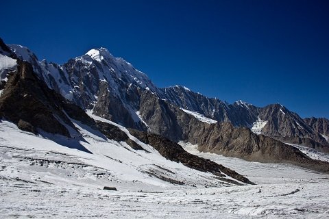
At 4,703 meters, where the air thins and the Darkot Glacier spills between walls of 6,000-meter peaks, you stand on one of the great historic crossings of the Hindu Kush. Darkot Pass — also spelled Darkut or Darkote — links the Yasin Valley of Gilgit-Baltistan with the Broghil Valley of Chitral, and it has done so for well over a thousand years: Chinese armies marched over it in the 8th century, a British explorer of the Great Game died on it in 1870, and Yak caravans traded across it for generations. If you are a serious trekker looking for the pass less traveled, this Darkot Pass travel guide will tell you exactly what awaits.
Quick Facts
- Location: Between the Rawat Valley of Ghizer District (Gilgit-Baltistan) and the Baroghil Valley of Chitral (Khyber Pakhtunkhwa), in the Hindu Kush range
- Altitude: Around 4,703 meters (15,430 feet)
- Famous For: A glaciated high pass with 6,000-meter peak views, Great Game history, and the classic Darkot-to-Broghil trek
- Nearest City: Gilgit (about 7-8 hours by road to Darkot village) or Chitral town (via Mastuj and the Yarkhun Valley)
- Accessibility: Trekking only — jeeps reach Darkot village on the Yasin side and Iskarwaz on the Chitral side; the pass itself is crossed on foot over the Darkot Glacier
- Known Landmarks: Darkot Glacier, Chikar base camp, and the panorama of Koyo Zom (6,872 m), Garmush, and Chikar Zom
- Best For: Experienced trekkers, mountaineers, and history-minded adventurers — not casual sightseers
Why Visit Darkot Pass
Visit Darkot Pass because it is the real thing: a high, glaciated, demanding pass that has tested travelers since long before trekking was a sport. From the top, the view is a lifetime panorama of the Hindu Kush — to the east Garmush at 6,243 meters, to the south Dhulichhish at 6,518 meters, to the west Chikar Zom at 6,110 meters, and the great pyramid of Koyo Zom (6,872 m), the highest peak in Ghizer District, rising just ten miles away. Trekkers who have crossed it call it one of the finest high-pass experiences in Pakistan, precisely because so few people ever see it.
Darkot is also perfect for travelers who want history under their boots. This was the shortest line of communication between the Oxus and the Indus — the ancient link between Central Asia and the subcontinent. In 747 AD a Chinese army led by a Korean general crossed this very pass to conquer Gilgit and rout the Tibetans, an event that emptied Baltistan of Tibetan warlords within weeks. In 1870 the British explorer George Hayward crossed Darkot during the Great Game and was murdered here, making the pass a footnote in one of history’s great imperial rivalries. You do not just trek over a mountain; you walk through thirteen centuries of strategy, trade, and exploration.
Finally, Darkot is the gateway to one of Pakistan’s great multi-day journeys. The classic route runs from Darkot village in Yasin, over the pass, and down through Chikar and Iskarwaz into the Broghil Valley — 8 to 12 days of glacier travel, high meadows, and Wakhi villages, ending in a valley so remote it feels like another century. For trekkers who have done the famous Karakoram routes and want something rawer, Darkot is the answer.
A word of honesty: this is a strenuous, restricted-zone trek requiring permits, crampons, ropes, and a competent guide. It is not for beginners. But if you are ready, our Explore Pakistan series also covers gentler northern adventures like the Hunza Valley — and the Broghil Valley on the far side of the pass.
History of Darkot Pass
Darkot’s history is the history of the Hindu Kush as a highway. For centuries it served as the shortest means of communication between the Oxus (Amu Darya) basin and the Indus — the natural corridor linking Central Asia with the subcontinent. Wakhi herders of the Broghil side drove yak caravans over the pass into upper Yasin, trading local products for tea, spices, and food items from the Yasin markets, a trade small in scale but vital to these isolated valleys.
The pass entered world history in 747 AD, when a Chinese army under the Korean general Kao Hsien-chih crossed Darkot to strike at the Tibetan garrisons holding Gilgit and the Ghizer valley. The campaign was a complete success: the Tibetans were routed in Wakhan and the Ghizer valley, and within weeks Baltistan was emptied of its Tibetan warlords. The Chinese general even destroyed the bridge at Gupis on his way back to prevent the Tibetans from returning — a 1,300-year-old story of mountain strategy that trekkers still walk through today.
Eleven centuries later, Darkot became a stage of the Great Game. In 1870 the British explorer George Hayward — mapping the Pamirs for the Royal Geographical Society at the height of Anglo-Russian rivalry — crossed the Darkot Pass and was murdered here, making the pass famous in the annals of exploration. In modern times the pass has been designated a restricted zone by the Government of Pakistan, which is why trekkers need permits from the Deputy Commissioner of Chitral and the Chitral Scouts headquarters at Mastuj before attempting the crossing.
Top Things to Do in Darkot Pass
Trek from Yasin to Broghil Over the Pass
The classic Darkot expedition starts at Darkot village in the Yasin Valley, climbs through Rawat to the Darkot base camp, crosses the Darkot Glacier to the 4,703-meter pass, and descends the steep far side to Chikar and Iskarwaz in the Yarkhun Valley before continuing to Broghil. The full journey takes 8 to 12 days including acclimatization. The glacier crossing involves crevasses and a steep, sometimes slippery descent — crampons and ropes are required, and the trek is rated strenuous.
Stand on the Pass and Read the Panorama
The summit rewards the effort with one of the great views of the Hindu Kush: Koyo Zom (6,872 m) to the east, Garmush (6,243 m), Dhulichhish (6,518 m), and Chikar Zom (6,110 m) ringing the horizon, with granite peaks and glaciers in every direction. On a clear morning, with the Karakoram and Pamir ranges faint in the distance, it is the kind of view trekkers remember for decades.
Explore Darkot Village
Before the climb, spend time in Darkot village on the Darkot River, a tributary of the Ghizer River. Known for its traditional architecture and hospitable people, it is the last settlement of any size on the Yasin side — stock up, hire porters here, and acclimatize with day walks in the surrounding meadows.
Continue to Broghil Valley
Most trekkers do not stop at the pass. The route continues through the Yarkhun Valley’s villages — Chikar, Iskarwaz, Kishmanja, Lasht — into the Broghil Valley, a high, wildlife-rich valley of Wakhi herders near the Afghan border. Broghil’s meadows, lakes, and isolation make it one of Pakistan’s most extraordinary destinations in its own right.
Visit Kurumbar Lake
An alternative or extension from the Chikar area leads over the Qurumbar Pass to Kurumbar Lake, one of the high alpine lakes of the region, with the Shuij Glacier beyond. It adds days to the expedition but rewards with pristine, crowd-free mountain scenery.
Famous Places In and Around Darkot Pass
- Broghil Valley — The remote Wakhi valley on the Chitral side, with meadows, lakes, and the Broghil Pass into the Wakhan Corridor region.
- Kurumbar Lake — A high alpine lake reached via the Qurumbar Pass from the Chikar side.
- Yasin Valley — The green valley on the Gilgit-Baltistan side, with Sandi village and its historic fort.
- Chitral Town — The historic town at the end of the Yarkhun route, with its fort and bazaars.
- Koyo Zom Base — The approaches to Ghizer District’s highest peak, visible from the pass.
How to Reach Darkot Pass
Darkot is reached from two sides, and most expeditions start on one side and finish on the other. The Yasin (Gilgit-Baltistan) approach: drive from Gilgit to Gahkuch, then up the Yasin Valley to Darkot village — about 7 to 8 hours from Gilgit via Phander and Gupis. The Chitral approach: drive from Chitral town to Mastuj, then up the Yarkhun Valley through Lasht, Kishmanja, and Iskarwaz to Chikar, where the trek to the pass begins (about 12 to 13 hours from Chitral town to the Broghil side trailheads, usually split over days).
From Islamabad: For the Yasin side, drive the Karakoram Highway to Gilgit (a full day), then on to Yasin and Darkot village. For the Chitral side, drive to Chitral via the Lowari Tunnel (about 10 hours) or fly Islamabad to Chitral when flights operate, then drive up the Yarkhun Valley.
From Lahore: Travel to Islamabad first (4-5 hours by motorway), then follow the Islamabad routes above. This is a multi-day journey to the trailhead — plan accordingly.
From Karachi: Fly to Islamabad (about 2 hours), then continue by road or domestic flight as above. Most Karachi-based trekkers join an organized expedition that handles the long approach.
Nearest airport: Gilgit Airport for the Yasin approach; Chitral Airport for the Chitral approach. Both have limited, weather-dependent flights from Islamabad.
Road conditions by season: The approach roads are open roughly May to October. The pass itself is generally crossable from late June to September, when the snow has melted enough for the glacier route. Outside this window, heavy snow makes the trek impassable.
Transport options: Private 4×4 or hired jeep to Darkot village or Iskarwaz; public transport reaches Gupis/Yasin and Mastuj, from where jeeps can be arranged. Given the permits, porters, and technical gear involved, most trekkers go with an experienced tour operator.
Route Details
Yasin side: Gilgit → Gahkuch → Phander → Gupis → Yasin → Darkot village → Rawat → Darkot base camp → Darkot Pass (4,703 m) → Chikar → Iskarwaz → Kishmanja → Lasht → Mastuj → Chitral. Permits required: obtain permission from the Deputy Commissioner of Chitral and the Chitral Scouts headquarters at Mastuj before attempting the crossing.
Where to Stay in Darkot Pass
This is expedition country — there are no hotels at the pass, and accommodation means tents, village guesthouses, and the occasional shepherd shelter.
Camping: The standard for the entire trek. Camp at Rawat, the Darkot base camp, Chikar, and the high meadows beyond. Bring a four-season tent, a sleeping bag rated well below freezing, and full cooking gear.
Village guesthouses: Darkot village and the Yarkhun villages (Iskarwaz, Lasht) have basic guesthouses and homestays — simple rooms, home-cooked food, and invaluable local advice. Arrange through your guide.
Base towns: For proper hotels, stay in Gilgit or Chitral town before and after the trek. Both have mid-range hotels with hot water and restaurants — deeply appreciated after 10 days on the glacier.
Where to Eat: Local Foods of Darkot Pass
On the trek, you eat what you carry plus what the villages offer. The valleys around Darkot live on mountain staples: fresh wheat breads, dairy products — butter, yogurt, and cheese from household cattle and yaks — dried apricots and mulberries, and salt tea, the warming pink-tea-with-salt that is the north’s universal welcome. In Darkot village and the Yarkhun settlements, homestays serve simple, hearty home cooking: lentils, potatoes, rice, and occasionally meat.
There are no restaurants on the trail, so expedition food must be planned and packed in Gilgit or Chitral — high-energy staples like nuts, dried fruit, chocolate, and instant noodles, plus proper meals cooked at camp. In the base towns, Chitral’s bazaar offers the region’s flavors: Chitrali patti bread, local honey, and dried fruits at budget-friendly prices. Carry more food than you think you need; the mountains do not have shops.
Weather in Darkot Pass
Darkot is a high-alpine environment where weather changes fast and winter never fully leaves the glaciers. The crossing window is short, and conditions on the pass bear little resemblance to the valleys below.
| Season | Temperature Range | Conditions |
|---|---|---|
| Winter (Nov-Apr) | Well below -15°C at the pass | Deep snow; the pass is closed and the trek is impossible |
| Spring (May-Jun) | Around -5°C to 8°C at altitude | Snow melting; early-season attempts are risky and the glacier is heavily snow-covered |
| Summer (Jul-Sep) | Around 0°C to 12°C at the pass | The crossing season — relatively stable weather, melted snow on the route, cold nights |
| Autumn (Oct) | Around -10°C to 5°C | Early snowfalls can close the pass with little warning; late attempts are a gamble |
Language and Culture of Darkot Pass
The pass sits at a linguistic crossroads. On the Yasin side, people speak Burushaski (the unique language isolate of the Hunza-Yasin region); on the Chitral side, Khowar dominates, while the Broghil Valley beyond is home to Wakhi herders. Urdu serves as the common language for visitors.
Mountain hospitality here is profound — villagers in Darkot and the Yarkhun settlements routinely welcome trekkers with tea and shelter. Respect it by dressing modestly, asking before photographing people, and hiring local porters and guides rather than bringing everything from outside; the trek economy matters to these remote communities. The Wakhi and Burusho cultures have distinct traditions of music, dance, and dress — if you are invited to a local gathering, consider it a privilege.
Shopping in Darkot Pass
There is no shopping on the trek — and no shopping malls anywhere near it. What you can buy is in the base towns: Chitral’s bazaar sells Chitrali patti (handwoven woolen cloth), woolen caps and shawls, local honey, and dried apricots and mulberries. Yasin’s villages offer similar woolen goods. Buy your souvenirs in Chitral or Gilgit before or after the expedition; on the trail, your money goes to porters, homestays, and the occasional dozen eggs.
Travel Tips for Darkot Pass
Packing Essentials
Four-season tent, sleeping bag rated to -15°C or lower, crampons, ice axe, rope, harness, and helmet; layered clothing including a down jacket, waterproof shell, and warm hat and gloves even in August; glacier sunglasses, high-SPF sunscreen, water purification, a comprehensive first-aid kit with altitude medication (consult your doctor), and a satellite communicator — there is no mobile signal on the pass.
Safety Tips
This is a strenuous, technical, restricted-zone trek. Go only with an experienced local guide, allow days for acclimatization, and never attempt the glacier alone. Check weather obsessively — storms move in fast at 4,700 meters. Secure your permits from the DC Chitral and Chitral Scouts well in advance, and register your expedition plan with someone reliable.
Money & Connectivity
Carry all cash in Pakistani rupees — there are no ATMs beyond Gilgit and Chitral town, and none whatsoever on the trek. Mobile signals vanish once you leave the main valleys; some networks work in Darkot village and parts of Yarkhun, but plan to be offline for most of the expedition.
Best Time to Visit Darkot Pass
July to September — The Crossing Season
The only reliable window. Snow has melted off the route, the glacier is passable, and the weather is at its most stable. August is the classic month for the crossing.
Mid-June and October — Shoulder Season
Possible for experienced parties watching the weather closely, but early snow or late melt can shut the route without warning.
November to May — Closed
Heavy snow makes the pass impassable. The valleys below are reachable, but the crossing is not attempted.
Final Thoughts
Darkot Pass is not a destination you tick off — it is an expedition you earn. The altitude, the glacier, the permits, and the sheer remoteness filter out everyone except those who truly want to be there, and that is exactly what makes the crossing special. You will walk a route that carried Chinese armies, Great Game explorers, and generations of yak caravans, and you will likely share the view from 4,703 meters with no one but your team.
If you are ready for one of the great high-pass treks of the Hindu Kush, Darkot is waiting — in July, August, and September, when the snows relent and the mountains open their doors. Train well, go with a good guide, and treat the pass with the respect thirteen centuries of travelers have given it. For more northern journeys at every level of ambition, browse our Explore Pakistan collection, from the Hunza Valley to the Chitral region beyond the pass.
FAQs
Where is Darkot Pass located?
Darkot Pass sits in the Hindu Kush on the border between Gilgit-Baltistan and Khyber Pakhtunkhwa, connecting the Rawat Valley of Ghizer District (near Yasin) with the Baroghil Valley of Chitral.
What is the altitude of Darkot Pass?
The pass stands at around 4,703 meters (15,430 feet) above sea level.
What is the best time to visit Darkot Pass?
July to September is the reliable crossing season, when the snow has melted and the glacier route is passable. The pass is generally open from May to October but is only safely crossable in the summer window.
How do I reach Darkot Pass?
Drive to Darkot village in Yasin (about 7-8 hours from Gilgit) or to Chikar/Iskarwaz in the Yarkhun Valley from Chitral, then trek over the pass via the Darkot Glacier. Permits from the DC Chitral and Chitral Scouts HQ at Mastuj are required.
Is Darkot Pass safe for tourists?
For experienced, well-equipped trekkers with a local guide, yes. It is a strenuous, technical, restricted-zone trek requiring crampons, ropes, and acclimatization — not suitable for beginners or casual visitors.
Is Darkot Pass good for families?
No. The altitude, glacier travel, and multi-day expedition format make it unsuitable for children and casual family trips. Families should enjoy Yasin or Chitral valleys instead.
Where can I stay near Darkot Pass?
Camping is the standard on the trek. Basic guesthouses exist in Darkot village and the Yarkhun villages; proper hotels are in Gilgit and Chitral town.
What is the history of Darkot Pass?
It was the shortest Oxus-to-Indus route for centuries. A Chinese army crossed it in 747 AD to conquer Gilgit from the Tibetans, and the British explorer George Hayward crossed it in 1870 during the Great Game — and was murdered here.