Some mountains welcome tourists with cable cars and coffee shops. Also, Istor-o-Nal does not. It rises 7,403 metres above the remote Tirich Valley of Upper Chitral, the third highest mountain in the Hindu Kush and the 68th highest independent peak on Earth. It asks one simple question of you: are you ready? This is not a destination for a casual weekend, but if you are a mountaineer, a trekker. A traveller hungry for the wildest corners of Pakistan, few places on the planet reward ambition like this one.
Here is your complete istor-o-nal travel guide — why it deserves a place on your expedition list, how to reach it, and when to go.
Quick Facts
- Location: Upper Chitral District, Khyber Pakhtunkhwa, northeast of Tirich Mir across the Tirich Glacier
- Altitude: around 7,403 metres (24,288 feet) at the summit; base camp sits near 4,200 metres
- Famous For: Third highest peak of the Hindu Kush; the 68th highest independent peak in the world; a historic 1955 first ascent
- Nearest City: Chitral town (around 135 km from the roadhead at Shagram); Buni is around 60 km away
- Accessibility: Fly or drive to Chitral, jeep to Shagram village in the Tirich Valley, then a 3–4 day trek to base camp
- Known Landmarks: Tirich Glacier, Tirich Mir, the Buni Zom range, Rosh Gol Valley
- Best For: Experienced mountaineers, high-altitude trekkers, expedition photographers, and serious adventure travellers
Why Visit Istor-o-Nal
Let us be honest from the start: most people will never stand on the summit of Istor-o-Nal. That is exactly the point. In an age when even Everest has traffic jams, this 7,403-metre giant remains one of the great quiet summits of the Hindu Kush. From many viewpoints it hides behind the higher Tirich Mir. It never collected the fame of its neighbour — which means the climber who goes here goes for the climbing, not the crowd.
The name itself pulls you in. As a result, In Khowar, the language of Chitral, “Istor-o-Nal” means horseshoe — Istor is horse — and the origin of the name remains unclear, one more small mystery attached to a mountain that does not give up its secrets easily. In fact, the massif crowns eleven separate peaks above 7,000 metres, a whole skyline of them. This means the trek to base camp alone walks you through some of the most dramatic glacier country in northern Pakistan.
Walk Inside a Mountaineering Legend
Then there is the history. On 8 June 1955, two young Americans and a Pakistani major climbed the west ridge on a shoestring budget and put one of the highest summits ever attained by Americans in the books. That story — a small, lightly financed Princeton Mountaineering Club expedition succeeding where bigger parties might have failed — still hangs in the air of the Tirich Valley. You can follow their route, sleep in the valleys where their porters slept, and look up at the same west ridge. How many travel experiences let you walk inside a mountaineering legend like that?
Finally, there is Chitral itself. Also, the road to Istor-o-Nal passes through one of Pakistan’s most fascinating cultures: the Kho people, their music and polo, the Chitral Fort. The side valleys of the Kalash just a few hours away. An expedition here is never only about the mountain. It is about the villages that guard its approaches, the porters who make the climb possible. The sheer scale of a landscape that swallows roads and towns whole. If you want Pakistan raw and undiluted, start here.
History of Istor-o-Nal
Unlike the ancient towns of the plains, a 7,403-metre summit has no ruins to date. Its recorded history is the history of the people who lived in its shadow and the climbers who came to conquer it. The Tirich Valley below the peak has been inhabited for centuries by Kho-speaking communities whose ancestors traded and herded across the high passes of the Hindu Kush. The upper Tirich Glacier and the Rosh Gol routes were once used by traders and pilgrims, and old trails still thread through these valleys.
Chitral’s modern history frames the mountain’s story. Also, the princely state of Chitral, ruled by the Mehtar, survived as a princely state through the British era and acceded to Pakistan in 1947, merging fully into the North-West Frontier Province (now Khyber Pakhtunkhwa) in 1969. In fact, for most of that time the great peaks above the Tirich Valley were barely mapped, let alone climbed.
That changed on 8 June 1955, when Istor-o-Nal received its first ascent. Also, the team — Americans Joseph E. In fact, Murphy Jr. and Thomas A. Mutch, led by Pakistani Major Ken Bankwala — was a Princeton Mountaineering Club expedition, famously small and minimally financed by the standards of Himalayan climbing at the time. They climbed the west ridge, approaching from the south side of the peak via the Tirich Glacier. Their success was, at the time, the second highest summit ever attained by Americans. It marked an important moment in the exploration of the high Hindu Kush.
Murphy later wrote the account up in the 1956 American Alpine Journal (“The Ascent of Istor-o-Nal”). This remains the classic record of the climb.
Since then, Istor-o-Nal has stayed what it always was: a serious, remote expedition mountain. Commercial climbing here never took off the way it did in the Karakoram, so every expedition still carries something of that 1955 spirit — self-reliant, lightly supported, and far from the crowds. The region’s mountaineering history is still being written, with the massif’s unclimbed northeast and east summits waiting for the next generation of climbers.
Top Things to Do in Istor-o-Nal
A quick note before this section: Istor-o-Nal is an expedition objective, not a sightseeing stop. Also, everything below assumes proper acclimatisation, a registered expedition with permits, and an experienced local outfitter. Do not attempt any of this casually.
The West Ridge Expedition
The classic line is still the 1955 route: the west ridge, gained from the south side via the Tirich Glacier. Modern expeditions follow the same broad plan — Islamabad briefing, travel to Chitral, jeep to Shagram village at the head of the Tirich Valley, then a 3–4 day trek through Rosh Gol to a base camp beside the upper Tirich Glacier at around 4,200 metres. From there the route climbs through a glacier traverse and moraine zone to Camp I (around 5,100 m), an ice slope and ridgeline to Camp II (around 6,000 m). A high camp below the summit ridge (around 6,800 m) before the 8–12 hour summit push.
The grade is Alpine D to D+, mixed ice, snow and rock, with steep couloirs, exposed ridgelines, crevassed glaciers and harsh weather as the main challenges.
Trek to Base Camp
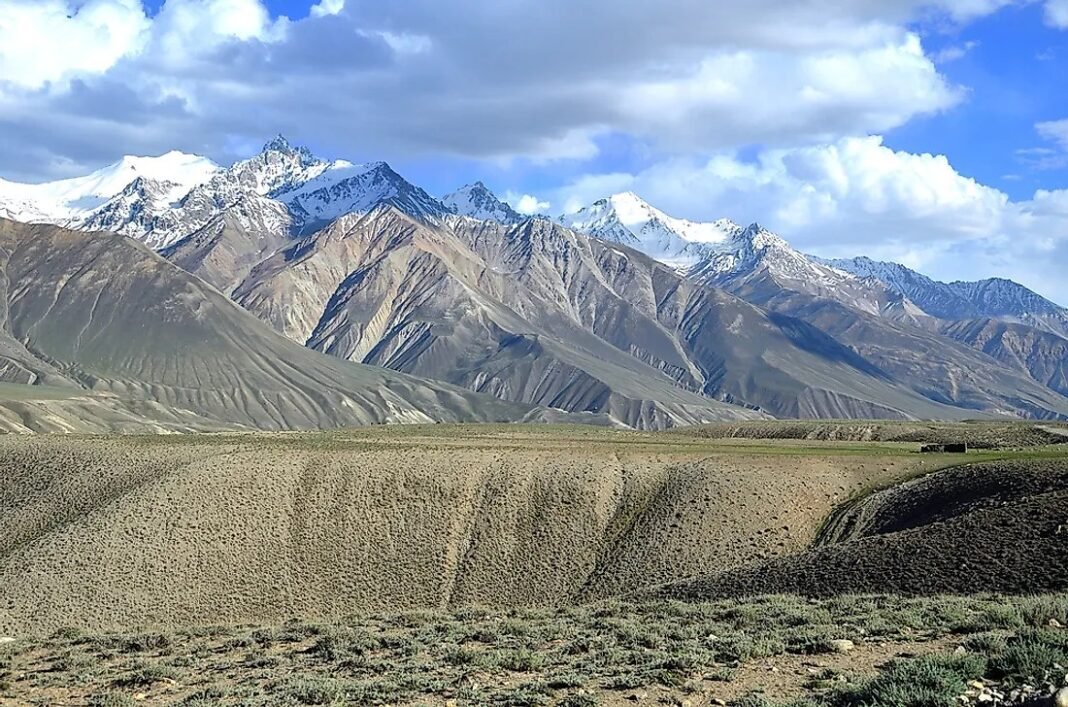
You do not have to summit to have the adventure of a lifetime. The trek from Shagram through the Rosh Gol Valley to base camp is one of the great unheralded walks of the Hindu Kush. A 3–4 day journey through high pastures, alongside glaciers, and into a cirque ringed by 7,000-metre peaks including Tirich Mir, Noshaq and the Buni Zom range. This is strenuous high-altitude trekking, but for fit walkers with a guide it is the most accessible way to stand in the mountain’s presence.
Photography at the Tirich Glacier
The upper Tirich Glacier is a photographer’s dream: seracs, icefalls. Also, a horizon stacked with some of the highest mountains in the Hindu Kush. In fact, early morning light on the west ridge of Istor-o-Nal, with Tirich Mir looming to the southwest, is the shot that defines the region. Bring spare batteries — cold drains them fast above 4,000 metres.
Wildlife Watching
The valleys around the massif hold Himalayan ibex on the high crags. Also, the lucky and patient may catch signs of snow leopard. In fact, Himalayan birds — lammergeiers, golden eagles, snowcocks — are a near certainty on the trek in. Keep your distance, keep quiet, and let a local guide read the slopes for you.
Explore Shagram and the Tirich Valley Villages
The uppermost village of the Tirich Valley, Shagram, is the expedition’s roadhead and a cultural experience in its own right. Also, stone houses, terraced fields, walnut and apricot orchards. In fact, Kho hospitality — take a rest day here to acclimatise and to meet the porters and villagers whose knowledge of these mountains is generations deep.
Famous Places In and Around Istor-o-Nal
- Tirich Mir (7,708 m) — the highest mountain in the Hindu Kush, towering just southwest across the glacier.
- Noshaq (7,492 m) — the massif’s nearest higher neighbour, near the Afghan frontier.
- Rosh Gol Valley — the historic trekking corridor into base camp, once used by traders and pilgrims.
- Chitral town — fort, bazaars and polo ground; your last proper town before the mountains.
- Chitral Gol National Park — home to the markhor, a worthy side trip from Chitral; see our Chitral Gol National Park travel guide.
- Kalash Valleys — Bumburet, Rumbur and Birir, a few hours from Chitral, with a culture found nowhere else on Earth.
How to Reach Istor-o-Nal
Reaching Istor-o-Nal is a proper expedition in itself, and that is part of the adventure. Also, the gateway is Chitral town, which you reach from Islamabad either by air or by a long, spectacular road journey. From Chitral, a jeep road runs up the Tirich Valley to Shagram village — around 135 km from Chitral town and 60 km from Buni — and from Shagram you trek 3–4 days to base camp. There is no shortcut: every metre of altitude is earned.
From Islamabad, the road route runs via the Swat Motorway and the Lowari Tunnel into the Chitral Valley — roughly 365 km and typically 10–12 hours of driving, depending on conditions and stops. Also, flights from Islamabad to Chitral operate subject to weather and can cut the journey dramatically. They are frequently cancelled, so build buffer days into your plan. Meanwhile, from Lahore, add the Islamabad leg first — most expeditions assemble in Islamabad and travel north together. From Karachi, fly to Islamabad and join the expedition there. The overland journey from Karachi is not practical for an expedition schedule.
The nearest airport is Chitral Airport, with scheduled flights from Islamabad (weather permitting). Also, within the region, 4×4 jeeps are the standard transport from Chitral to Shagram, and porters and pack animals carry loads from Shagram to base camp. Tour operators in Islamabad and Chitral arrange the full logistics chain, including the climbing permits required for peaks above 6,000 metres.
Road conditions: the Lowari Tunnel has transformed winter access to Chitral. Also, the jeep track beyond Buni into the Tirich Valley is rough, narrow and strictly fair-weather. In fact, it is only reliably passable in the June–September climbing season. Outside that window, snow closes the upper valley entirely.
Route Details
- Islamabad → Chitral: fly to Chitral Airport (weather permitting) or drive via Swat Motorway → Lower Dir → Lowari Tunnel → Chitral (10–12 hours).
- Chitral → Buni → Shagram: jeep up the Mastuj road, then into the Tirich Valley to Shagram, the uppermost village (full day).
- Shagram → Rosh Gol → Base Camp: 3–4 day trek with porters to base camp beside the upper Tirich Glacier (around 4,200 m).
- Base Camp → Camps I–III → Summit: the climbing route proper — glacier traverse, ice slopes, ridgelines and the summit push.
- Return: retrace to Shagram, jeep to Chitral, then fly or drive back to Islamabad.
Where to Stay in Istor-o-Nal
Let us be clear: there are no hotels on the mountain. Also, accommodation on an Istor-o-Nal expedition falls into three very different worlds. In fact, in Islamabad, expedition teams typically stay in guesthouses or mid-range hotels in the F-6/F-7 sectors for briefings and gear checks. In Chitral town, a cluster of mid-range hotels and guesthouses around the bazaar and polo ground serves travellers year-round — book through your outfitter. They will know which are currently open and reliable. Buni has simpler guesthouse options for the night before the jeep push.
From Shagram onward, you sleep in tents — your expedition outfitter provides base-camp tents, kitchen tents and high-altitude tents, and porters carry the loads. Also, this is full expedition camping at serious altitude: bring a sleeping bag rated well below freezing even in summer. There is no “luxury” tier here, and that is the honest truth. The luxury is the mountain itself.
Where to Eat: Local Foods of Istor-o-Nal
On the mountain you eat what the expedition kitchen cooks — typically hearty Pakistani staples (daal, rice, chapati, lentils, tea in industrial quantities) designed to fuel climbers. But the culinary journey to the mountain is half the fun. In Chitral town, try the region’s own dishes: Shoshp, the famous Chitrali buckwheat pancake. Pandir Muzhi, a savoury cheese-and-wheat dish; Ghalmandi, layered flatbread with cheese; and Zholai, a traditional walnut-and-wheat porridge. Dried apricots, mulberries and walnuts from the valley orchards are the perfect trekking snacks — buy them in the Chitral bazaar before heading up.
In the Tirich Valley villages, hospitality is generous and simple: expect fresh dairy, local bread, and endless cups of salted or sweet chai. Also, eat what your hosts offer, eat it gratefully, and carry extra snacks of your own for the trek. In fact, there are no shops beyond Shagram.
Weather in Istor-o-Nal
The weather on Istor-o-Nal is the weather of the high Hindu Kush: extreme, fast-changing, and utterly indifferent to your schedule. At base camp (around 4,200 m) summer days can be pleasantly cool and sunny, but nights fall well below freezing, and storms can arrive with almost no warning at any time. Also, above 6,000 metres, expect severe cold, high winds and whiteout conditions. The climbing season is June to September for a reason — outside it, the mountain is effectively closed.
| Season | Temperature Range (Base Camp, ~4,200 m) | Conditions |
|---|---|---|
| Winter (Nov–Feb) | -20°C to -5°C | Deep snow, extreme cold, upper valley inaccessible; no expeditions |
| Spring (Mar–May) | -10°C to 8°C | Heavy snow still on route; avalanche risk high; not a climbing window |
| Summer (Jun–Sep) | -8°C to 15°C | Prime climbing season; stable-ish weather but storms still frequent |
| Autumn (Oct) | -15°C to 5°C | Window closing fast; early snow, route shuts down |
Language and Culture of Istor-o-Nal
The valleys below Istor-o-Nal belong to the Kho people, who speak Khowar — the language that gave the mountain its name. For example, the Kho are renowned across the north for their hospitality, their music (the sitar-like sitār and traditional dance), and their passion for polo. Travellers are treated as honoured guests; accept tea when offered, dress modestly, and ask before photographing people.
The wider Chitral region also includes the Kalash valleys to the south, home to Pakistan’s unique Kalash community with their own religion, festivals and dress. If your expedition schedule allows, a side trip to Bumburet or Rumbur is one of the great cultural experiences in the country. Throughout the region, respect local norms: modest clothing, no alcohol in villages, and patience with the unhurried mountain pace of life.
Shopping in Istor-o-Nal
There is no shopping on the mountain — buy everything in Chitral town before the jeep ride. The Chitral bazaar is famous for Chitrali topis (the distinctive woollen caps), handwoven shu (coarse woollen cloth), embroidered waistcoats. It dried fruits and nuts from the valley orchards. If you extend your trip to the Kalash valleys, look for Kalash handicrafts and beadwork. Buy from local shops and artisans directly; your rupees go furthest in the community that way.
Local Events and Festivals
If you time your expedition for early July, you may catch the Shandur Polo Festival (traditionally 7–9 July) at the world’s highest polo ground on the Shandur Pass between Chitral and Gilgit-Baltistan — freestyle polo, folk music and dancing at 3,700 metres, and one of the great cultural spectacles of the north. It sits a long drive from the Tirich Valley, but many expeditions build it into their itinerary. They fall outside the climbing season.. Still, in the Kalash valleys, the Chilam Joshi spring festival (mid-May) and the winter Chaumos festival (December) are extraordinary cultural events,
Travel Tips for Istor-o-Nal
Packing Essentials
This is a full expedition packing list, not a holiday one: four-season mountaineering boots, crampons, ice axe, harness, helmet, down suit or heavy down layers, a sleeping bag rated to at least -20°C, glacier sunglasses, high-SPF sunscreen. Meanwhile, a comprehensive first-aid and altitude-medicine kit. Your outfitter will provide tents, ropes and cooking gear. Do not skimp on socks.
Safety Tips
Istor-o-Nal is graded Alpine D to D+ for good reason: crevasses, seracs, steep ice and sudden storms are all real hazards. Go only with a registered, experienced outfitter. Carry a satellite communicator. Build proper acclimatisation days into the schedule; and respect the mountain’s weather — turn around when conditions deteriorate. Register your expedition and permits through the proper channels before you travel.
Money & Connectivity
Carry all the cash you will need in Pakistani rupees from Islamabad or Chitral. Also, there are no ATMs beyond Chitral town, and none at all in the Tirich Valley. Mobile signals fade fast beyond Buni; expect no connectivity at base camp. A satellite phone or messenger device is standard expedition equipment. Inform family of your itinerary and check-in schedule before you leave Chitral.
Best Time to Visit Istor-o-Nal
Summer (June–September) — the climbing season
This is the only real window. Also, the jeep track to Shagram is open, the trekking route is passable, and base camp is inhabitable. June and September are quieter and colder. July and August are the most stable and the busiest. If you are coming to climb or trek to base camp, come now. There is no alternative.
Spring (March–May) — not recommended
Heavy snow still blankets the route and avalanche danger is high. The upper valley is effectively closed to expeditions. If you must visit Chitral in spring, stay in the town and lower valleys and enjoy the blossom season instead.
Autumn (October) — the window closes
Early autumn snow shuts the route down. Also, only the hardiest (or most poorly advised) attempt anything this late. The lower valleys, though, are beautiful in autumn colour.
Winter (November–February) — closed
Deep snow, extreme cold and an inaccessible upper valley. Also, the mountain waits. Plan next summer’s expedition instead.
Final Thoughts
Istor-o-Nal will never be an easy destination, and it should not try to be. Also, its value lies precisely in its difficulty — in the days of trekking to reach it, in the history written on its west ridge in 1955, and in the silence of a 7,000-metre massif that the crowds have not found. In fact, for the mountaineer, it is a serious and worthy objective. For the trekker, the base-camp journey is a genuine adventure. For the traveller, even the road through Chitral to its foothills is an education.
If you are choosing your next great mountain adventure in Pakistan, put Istor-o-Nal on the shortlist — then train hard, find a good outfitter, and go in summer. Also, the horseshoe mountain is waiting, and it does not hurry for anyone. For more northern adventures, browse our Explore Pakistan collection or start with our Chitral travel guide.
FAQs
Where is Istor-o-Nal located?
Istor-o-Nal is in Upper Chitral District, Khyber Pakhtunkhwa, in the Hindu Kush range — a few kilometres northeast of Tirich Mir, across the Tirich Glacier.
How high is Istor-o-Nal?
The summit is around 7,403 metres (24,288 feet), making it the third highest mountain in the Hindu Kush and the 68th highest independent peak in the world.
What is the best time to visit Istor-o-Nal?
June to September is the only viable window for expeditions and base-camp treks. Also, the upper valley is snowbound the rest of the year.
How do I reach Istor-o-Nal?
Travel to Chitral town from Islamabad (flight or 10–12 hour drive via the Lowari Tunnel), take a jeep to Shagram village in the Tirich Valley, then trek 3–4 days to base camp.
Is Istor-o-Nal safe for tourists?
It is an expedition mountain, not a tourist site. Also, it is suitable only for experienced mountaineers and trekkers with a registered outfitter, proper permits, and full high-altitude gear.
Who first climbed Istor-o-Nal?
On 8 June 1955, Americans Joseph E. Also, Murphy Jr. and Thomas A. In fact, mutch, led by Pakistani Major Ken Bankwala, on a Princeton Mountaineering Club expedition via the west ridge.
The origin of the name is unclear.. Still, what does Istor-o-Nal mean?
In Khowar, the language of Chitral, it means “horseshoe” (Istor = horse),
Where can I stay near Istor-o-Nal?
In hotels and guesthouses in Chitral town before the climb, and in expedition tents from Shagram onward. There are no hotels on the mountain itself.