Quick Facts
- Location: Nagar District, Gilgit-Baltistan, Pakistan, in the Karakoram range, just east of Rakaposhi
- Altitude: around 7,266 metres (23,839 ft) — some sources quote 7,273 metres
- Famous For: a near-perfect pyramid of snow and ice; one of the most photographed peaks of the Karakoram; the Minapin and Diran base-camp treks
- Nearest City: Gilgit, roughly an hour’s drive away on the Karakoram Highway
- Accessibility: road (KKH to Minapin village) plus a multi-day trek to base camp; Gilgit Airport is the nearest air link
- Known Landmarks: Minapin village, Minapin Glacier, Hapakun meadows, Tagaphari (Rakaposhi base camp viewpoint)
- Best For: trekkers, photographers, mountaineering-history lovers, and travellers who want Karakoram grandeur without the crowds of Skardu or Hunza’s main towns
Why Visit Diran Peak
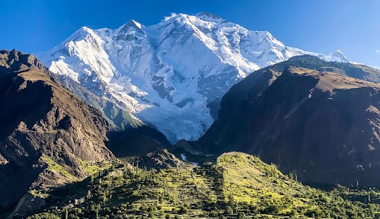
Most travellers racing up the Karakoram Highway have their eyes on Rakaposhi — and fair enough, Rakaposhi is magnificent. But look just to the east of it and you will see a peak so geometrically perfect it hardly looks real: Diran Peak, a 7,266-metre pyramid of snow and ice that rises above the orchards of Nagar like something drawn by a compass. Ask any trekker who has stood in the meadows of Hapakun at sunrise, watching Diran catch fire in shades of pink and gold, and they will tell you this mountain does not play second fiddle to anything.
What makes Diran Peak special for ordinary travellers — not just climbers — is how close you can get to it. The Minapin valley provides some of the easiest access to any 7,000-metre peak in Pakistan. From the village of Minapin on the KKH, a trek of a few days climbs through terraced fields, pine forest and high summer pastures to meadows that sit almost at the foot of the mountain. You do not need to be an elite mountaineer to stand where the great expeditions stood. You need reasonable fitness, a few days, and a willingness to walk.
Diran is also a mountain with a story. Climbers know it as the “killer peak” — a name earned the hard way, through decades of avalanches that defeated British, German and Austrian expeditions before three Austrians finally stood on its summit in 1968. For history lovers, following the old expedition route from Minapin to base camp is a walk through mountaineering legend. For everyone else, the valley itself is the reward: apricot and cherry orchards, some of the warmest hospitality in Gilgit-Baltistan, and views that include not just Diran but Rakaposhi, Golden Peak and the great sweep of the Karakoram.
This is the perfect destination if you want the big-mountain experience of the Karakoram without the logistics of Baltoro or the crowds of Fairy Meadows. It suits trekkers of moderate ability, photographers chasing the perfect pyramid silhouette, families based in Minapin or Nagar who want day walks with outrageous views, and anyone building a serious Explore Pakistan itinerary through Gilgit-Baltistan. Diran Peak deserves your visit because it is the Karakoram at its most beautiful and its most approachable — all in one mountain.
History of Diran Peak
Diran Peak — known locally as Minapin, after the village that guards its southern approaches — has been part of the climbing world’s imagination for nearly a century. Its history as a mountaineering objective begins with failure, repeated and costly. A British expedition attempted it in 1958 and was driven back. A German expedition tried in 1959 and was turned around by bad weather and deep snow. An Austrian expedition made the attempt in 1964, found hidden crevasses and towering snow domes on the northwest ridge, and retreated as the weather closed in.
The breakthrough came in 1968, when a three-man Austrian team — Rainer Goeschl, Rudolph Pischinger and Hanns Schell — climbed in lightweight alpine style and reached the summit, becoming the first people to stand on top of Diran. It was a landmark ascent for its era: no fixed ropes, no army of porters on the upper mountain, just three climbers moving fast and light over treacherous ground.
Success did not make Diran safe. The mountain’s steep faces shed avalanches with frightening regularity, and over the decades the peak earned a grim local nickname: the “killer peak”. A veteran Nagar expedition organiser, Raja Abbas, told the Express Tribune in 2012 that around 40 mountaineers had lost their lives on Diran by that point — a toll driven almost entirely by avalanches. The mountain’s last ascent before that report had been in 1993, and even in the modern era expeditions treat Diran with deep respect.
The human history around the mountain is older and richer than the climbing record. Diran stands over Nagar, which was an independent principality for more than 1,200 years, ruled by its own Mirs until the British took control during the Anglo-Brusho war — locally remembered as Jangir-e-Lae — fought at Nilt from 1 to 23 December 1891. For the Burusho people of Nagar, peaks like Diran were not sporting objectives but sacred presences on the horizon, the source of the glaciers that watered their fields. That older relationship still shows in the valley: ask a Minapin elder about Diran and you will hear pride first, not fear.
Today the mountain has settled into a second life as a trekking and photography icon. The old expedition route — Minapin to Gultens to Hapakum to base camp — is now one of the classic moderate treks of Gilgit-Baltistan, walked every summer by Pakistani and foreign trekkers who come for the mountain’s famous symmetry and stay for the valley’s orchards.
Top Things to Do in Diran Peak
Trek to Diran Base Camp via Minapin
The signature experience. Starting from Minapin village on the KKH, the trail climbs through cultivated terraces and irrigation channels, then opens into pine forest and finally the great summer pastures of Hapakun. Expeditions historically placed base camp in the meadows below the Minapin Glacier, at around 3,400 metres, and modern trekkers follow the same line: Minapin, Gultens, Hapakun, base camp. Allow four to six days round trip from the village, walking at a comfortable pace with a rest day built in. The reward is a front-row seat beneath one of the Karakoram’s most beautiful faces, with Rakaposhi looming to the west and the whole Nagar valley spread below.
This is a trek for fit beginners with a guide — no technical climbing, but real altitude and real weather. Hire a local guide in Minapin or Gilgit; porters are readily available in the village, and camping gear can be rented in Gilgit if you do not have your own.
Photograph the Pyramid at Sunrise and Sunset
Diran’s near-perfect pyramid shape makes it one of the most photogenic 7,000-metre peaks on earth. The classic shot is from the meadows around Hapakun or Tagaphari, with the mountain centred and Rakaposhi’s bulk anchoring the left of the frame. Arrive before dawn, set up, and watch the snow turn from grey to rose to burning gold as the sun clears the eastern ridges. In autumn, when the poplars and apricots of Nagar turn yellow and the air is at its clearest, the colours are almost unbelievable.
Walk the Orchards and Villages of Minapin and Nagar
You do not have to climb high to love this valley. Minapin village sits in a bowl of orchards — apricots, apples, cherries, mulberries, walnuts and pomegranates — threaded with irrigation channels that have run for centuries. Spend a day walking the village lanes, accepting the inevitable invitations for tea, and tasting fruit straight from the branch in season. The people of Nagar are famous across Gilgit-Baltistan for their hospitality, and Minapin, as the valley’s mountaineering hub, is used to welcoming travellers.
Combine with Rakaposhi Base Camp at Tagaphari
Diran’s neighbour Rakaposhi is the bigger name, and its base-camp viewpoint at Tagaphari is one of the most famous panoramas in Pakistan. The two treks share the same trailhead at Minapin and the same first day’s walking, so it is natural to combine them: Tagaphari for Rakaposhi, then onward and upward for Diran. Many trekkers do both in a single week-long trip.
Visit the Glaciers: Minapin, Hinarchi and Baultar
Diran is ringed by glaciers — Minapin, Hinarchi and Baultar — that spill from its flanks into the valley. The approach to base camp crosses the snout of the Minapin Glacier, a churning river of grey ice that groans and cracks as you walk. For anyone who has never stood on or beside a Karakoram glacier, it is a thrilling, humbling experience, and a reminder of where the valley’s water — and its orchards — come from.
Famous Places In and Around Diran Peak
- Minapin Village — the trekking trailhead on the KKH; hotels, guesthouses and guides
- Hapakun Meadows — high summer pastures with the classic Diran view
- Tagaphari — Rakaposhi base-camp viewpoint, combinable with the Diran trek
- Hopar Valley — nearby Nagar sub-valley with the Hopar (Hoper) Glacier
- Rush Lake — one of the world’s highest alpine lakes, trekked from Hopar
- Karimabad, Hunza — Baltit and Altit forts, across the river; see our Explore Hunza Valley guide
- Bagrot Valley — the valley Diran technically stands in; see our Bagrot Valley travel guide
How to Reach Diran Peak
Getting to Diran Peak means getting to Minapin village in Nagar District, which sits directly on the Karakoram Highway between Gilgit and Hunza. From there, the mountain is reached on foot — there is no road to base camp, and that is exactly as it should be.
From Islamabad: Drive the Karakoram Highway via Abbottabad, Mansehra, Besham and Chilas to Gilgit — around 510 km, a full 10 to 12 hours of spectacular but demanding driving. Most travellers break the journey with an overnight stop in Besham or Chilas. From Gilgit, Minapin is a short onward drive up the KKH toward Hunza, roughly 40 km or about an hour.
From Lahore: Take the motorway to Islamabad (about 375 km, 4–5 hours), then join the KKH route above. Budget two full days on the road to reach Gilgit, or fly to Islamabad and continue by road or air.
From Karachi: Fly to Islamabad (about 2 hours), then either continue by road up the KKH or take the connecting PIA flight to Gilgit. There are no direct commercial flights from Karachi to Gilgit.
Nearest airport: Gilgit Airport, served by PIA flights from Islamabad (around 45 minutes in the air, but frequently delayed or cancelled in bad weather — always keep a buffer day). Skardu Airport is a longer alternative with more reliable schedules.
Road conditions by season: The KKH to Gilgit is open year-round but can be blocked by landslides in the monsoon months and by snow at the high passes in winter. The Minapin road and the trekking trails are realistically accessible from May to October; the high pastures are snowbound outside that window.
Transport options: NATCO and private coach services run Islamabad–Gilgit daily; private cars and rented 4x4s are the flexible choice; tour operators in Gilgit and Hunza run scheduled Minapin/Rakaposhi treks all summer that include transport, guides, porters and camping gear.
Route Details
- Islamabad → (KKH) → Gilgit: ~510 km, 10–12 hours by road, or 45-minute flight (weather permitting).
- Gilgit → Minapin village: ~40 km north on the KKH toward Hunza, about 1 hour by car or van.
- Minapin → Gultens → Hapakun: the classic trekking line, 2–3 days of walking through terraces, forest and pasture.
- Hapakun → Diran Base Camp: a further half to one day, crossing toward the Minapin Glacier snout at around 3,400 metres.
- Return the same way, or combine with the Tagaphari/Rakaposhi side trail before descending to Minapin.
Where to Stay in Diran Peak
There are no hotels at base camp — this is a camping trek — but the valley below is well set up for travellers.
Minapin village: The natural base. Several hotels and guesthouses in the village cater specifically to trekkers and expeditions (one long-running hotel here is even named after the peak itself), offering simple, clean rooms, hot meals and help arranging guides and porters. Staying here puts you at the trailhead and among the orchards.
Mid-range: Guesthouses in Nagar Khas and Hopar offer comfortable rooms with valley views at reasonable rates; many trekkers spend their acclimatisation or rest nights here.
Luxury: For a splurge before or after the trek, the Serena hotels in Karimabad, Hunza (a short drive across the river) offer the region’s best-known luxury stay, with terraces facing Rakaposhi and Diran.
Camping: On the trek itself, camp at Gultens and Hapakun in your own or rented tents. The pastures are grazed in summer, so camp on established ground, well away from water channels, and carry all rubbish back down.
Where to Eat: Local Foods of Diran Peak
The food of Nagar is the food of Hunza and the central Karakoram: hearty, apricot-scented mountain cooking shaped by short summers and long winters.
Chapshuro is the dish to seek out — the famous Hunza-Nagar meat pie, minced beef or yak folded into wholewheat dough with onions, tomatoes and local spices, baked on a hot stone. Mamtu, steamed dumplings filled with minced meat, are the valley’s comfort food. Diram fitti, a sweet bread made with apricot kernels, walnuts and butter, is served to honoured guests. Gyaling, buckwheat pancakes, and dawdo, a warming hand-pulled noodle soup, round out the classics.
Drink tumoro cha — salty butter tea — the way locals do, and finish with dried apricots and apricot kernel oil, the valley’s signature products. In Minapin, hotel kitchens cook standard Pakistani traveller fare (daal, chicken karahi, chapati) alongside local dishes; a full meal in a village hotel is budget-friendly, roughly a few hundred rupees per person, while Karimabad’s restaurants charge more for tourist menus. In fruit season (June–August), orchards sell apricots, cherries and mulberries at the roadside for very little.
Weather in Diran Peak
Conditions change dramatically with altitude: Minapin village sits at around 2,000 metres, while base camp is at roughly 3,400 metres, where temperatures run 8–10 degrees colder and snow can fall in any month. The table below is for the valley floor and lower trekking zone — approximate ranges to help you plan.
| Season | Temperature Range | Conditions |
|---|---|---|
| Winter (Dec–Feb) | -10 to 2°C | Heavy snow; high trails closed; KKH open but slow |
| Spring (Mar–May) | 5 to 20°C | Blossom season in the orchards; trails open lower down from April |
| Summer (Jun–Aug) | 15 to 30°C | Prime trekking season; clear mornings, possible afternoon showers |
| Autumn (Sep–Nov) | 0 to 18°C | Golden foliage, crystal-clear air; snow returns to high pastures by November |
Language and Culture of Diran Peak
The people of Nagar are predominantly Burusho, speaking Burushaski — a language isolate found nowhere else on earth — with Shina also widely spoken and Urdu understood in the bazaars. The majority are Ismaili Muslims, followers of the Aga Khan, and the valley is known across Pakistan for its near-total literacy, its emphasis on girls’ education, and its genuinely warm welcome to visitors.
Cultural norms are relaxed by the standards of rural Pakistan, but dress modestly (cover shoulders and knees, especially for women), ask before photographing people, and accept tea when it is offered — refusing hospitality can offend. The irrigation channels that water the orchards are communally managed; do not wash or bathe in them. If you trek in summer, you will share the high pastures with Gujjar and Burusho herders; give their livestock space and keep dogs leashed.
Shopping in Diran Peak
Minapin has small general stores for trekking supplies (snacks, batteries, basic gear) but this is not a shopping destination — Gilgit’s bazaars are the place for serious buying. What you should buy here: dried apricots (the valley’s are among Pakistan’s finest), apricot kernel oil, walnuts, and hand-knitted woollen socks and caps sold by village women. Karimabad’s bazaar, an easy day trip, adds Hunza handicrafts — embroidered caps, shawls, and carved walnut-wood boxes. There are no shopping malls anywhere in the valley, and that is part of the charm.
Local Events and Festivals
Nagar shares the festival calendar of Hunza, and two celebrations are worth timing a trip around. Navroz, the Ismaili new year on 21 March, is marked with prayers, traditional music and community feasts. Ginani, the traditional harvest festival usually held in June after the wheat harvest, is the valley’s great cultural showpiece — polo matches, folk dancing, and the first tasting of the new grain. Dates shift slightly year to year, so confirm locally before planning around them.
Travel Tips for Diran Peak
Packing Essentials
Four-season sleeping bag (nights at base camp drop below freezing even in July), sturdy broken-in trekking boots, layered clothing, sun protection (the Karakoram sun at altitude is brutal), a headlamp, water purification, and a basic first-aid kit. Bring cash — there are no ATMs in Minapin.
Safety Tips
Diran’s nickname exists for a reason: above base camp, the mountain is for professional expeditions only. Trekkers should stay on the established trail, hire a local guide, and never cross glacier snouts without one. Acclimatise — gain height slowly and drink plenty of water. Weather changes fast; start walking early and be off exposed ridges by afternoon. Register your trekking plans with your hotel.
Money & Connectivity
Carry all the cash you will need from Gilgit — Pakistani rupees, in smaller notes. Mobile signals (SCO/SCom, Telenor and Zong have the best mountain coverage) work in Minapin village but fade on the upper trail. There is no Wi-Fi on the trek; download offline maps before you leave Gilgit.
Best Time to Visit Diran Peak
Spring (April–May): Blossom Season
The orchards of Nagar explode into white and pink blossom, and the lower trails open. The high pastures are still snowbound, so this is a season for village walks, photography and culture rather than base camp.
Summer (June–August): Trekking Season
The prime window. Trails to base camp are clear, the pastures are green, the fruit is ripening, and every viewpoint is open. Book guides and rooms ahead in July, the busiest month. Afternoon cloud build-ups are normal — start early.
Autumn (September–October): Golden Season
Arguably the most beautiful weeks of the year: poplars and apricots turn gold, the air is crystalline, and the crowds are gone. Snow can return to the high meadows by late October, so aim for September to early October for trekking.
Winter (November–March): For the Hardy
Deep snow, sub-zero nights and closed trails. Only for experienced winter travellers; the valley under snow has a stark, silent beauty, but Diran base camp is out of reach.
Final Thoughts
Diran Peak is the mountain that rewards the traveller who looks twice. Everyone photographs Rakaposhi from the KKH; the ones who stop, who walk up into Minapin and keep walking, find a pyramid of ice that rivals anything in the Karakoram, a valley of orchards and extraordinary hospitality, and a trek that asks for fitness but not for technical skill. It is the rare 7,000-metre peak you can genuinely get to know.
Go in summer for the full base-camp trek, or in autumn when Nagar turns to gold. Walk slowly, eat the apricots, learn a few words of Burushaski, and stand in the Hapakun meadows at dawn. Diran has waited through centuries of avalanches and expeditions; it will wait for you, too — but once you have seen it, you will wonder why you waited so long. For more northern inspiration, browse our Explore Pakistan collection.
FAQs
Where is Diran Peak located?
Diran Peak (7,266 m) stands in Nagar District, Gilgit-Baltistan, in the Karakoram range just east of Rakaposhi. Its southern approaches start from Minapin village on the Karakoram Highway.
What is the best time to visit Diran Peak?
June to August for trekking to base camp; September to early October for golden autumn colours and clear photography; April–May for orchard blossom in the valley.
How do I reach Diran Peak?
Drive or fly to Gilgit, continue about an hour up the KKH to Minapin village, then trek 4–6 days round trip via Gultens and Hapakun to base camp at around 3,400 metres.
Is Diran Peak safe for tourists?
The trekking route is safe for fit walkers with a local guide. The mountain above base camp is extremely dangerous (avalanche-prone) and is for professional expeditions only — trekkers should not attempt to climb it.
Is Diran Peak suitable for families?
The valley and village walks around Minapin suit families, including children. The full base-camp trek is best for teenagers and adults with good fitness; base the family in Minapin and do day walks.
Where can I stay near Diran Peak?
Hotels and guesthouses in Minapin village at the trailhead; more options in Nagar Khas and Hopar; luxury stays at the Serena hotels in nearby Karimabad, Hunza. Camping on the trek itself.
What local food should I try?
Chapshuro (meat pie), mamtu (dumplings), diram fitti (apricot-walnut sweet bread), dawdo (noodle soup), salty butter tea, and the valley’s famous dried apricots.
Why is Diran Peak called the killer peak?
Because of its history of deadly avalanches — around 40 mountaineers had died on its slopes by 2012, according to local expedition organisers — which defeated multiple early expeditions before the 1968 first ascent.