Quick Facts
- Location: Along the Jhelum River, Hattian Bala District, Azad Jammu and Kashmir
- Altitude: Valley floor along the river rising to Chikar hill station at 1,828 m and Dungia at 2,071 m
- Famous For: The Jhelum River gorge, panoramic riverside viewpoints, Chikar hill station, Zalzal Lake (born of the 2005 earthquake), waterfalls, and the gateway to Leepa Valley
- Nearest City: Muzaffarabad (~50 km from Hattian Bala); Islamabad (~130 km from Muzaffarabad)
- Accessibility: Metallic road from Muzaffarabad to Chakothi along the river, open year-round; side valleys by jeep track
- Known Landmarks: Chinari, Garhi Dupatta, Chikar, Zalzal Lake, Loon Bagla forest, Chakothi near the Line of Control
- Best For: Road-trippers, families, nature lovers, waterfall chasers, and travellers seeking Kashmir without the Neelum crowds
Why Visit Jhelum Valley
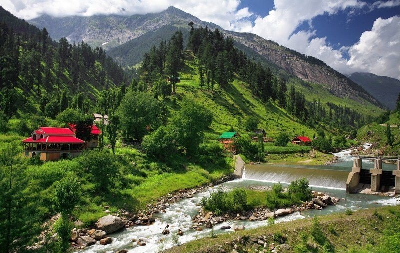
Ask most travellers about Azad Kashmir and they will name Neelum Valley. But the locals will tell you about the other valley — the one the Jhelum River carved through the mountains on its way from Srinagar, the one where the road itself is the attraction. Jhelum Valley is a 50-kilometre ribbon of green mountains, orchards and riverside villages stretching from Muzaffarabad to Chakothi near the Line of Control, and it is one of the most underrated drives in Pakistan. Here the Jhelum — wide, blue and fast — runs beside the road for the entire journey, with the mountains rising on both sides and a new viewpoint around every bend.
What makes Jhelum Valley worth choosing is its variety in a small space. In a single day you can stand at Garhi Dupatta where the town spills across both banks of the river, climb to the hill station of Chikar at 1,828 metres with its pine forests and PWD rest house, walk the dense woods of Loon Bagla, and stand at the shore of Zalzal Lake — a lake that did not exist before the morning of 8 October 2005, when the great Kashmir earthquake dropped a mountainside into the valley and the water rose behind it. Waterfalls punctuate the journey: Jaskol, about an hour and a half from Muzaffarabad, and Cham, reached by 4×4 from Chinari Bazaar. And from here, the legendary Leepa Valley — with its red rice fields and apple orchards — opens up over the 10,500-foot Reshian Gali.
Jhelum Valley is also Kashmir at its most accessible. The metallic Muzaffarabad–Chakothi road functions throughout the year thanks to the valley’s moderate weather, the towns have hotels, rest houses, health facilities and markets, and Islamabad is only about three and a half hours from Muzaffarabad. This is the valley for travellers who want the full Kashmir experience — river, forest, mountains, waterfalls, hill stations — without the long, rough jeep tracks of the remoter valleys. Come for the drive, stay for the viewpoints, and leave wondering why everyone goes only to Neelum.
History of Jhelum Valley
The Jhelum Valley’s history is the history of a frontier. Before 1947, this land was part of Uri Tehsil in the Baramulla district of the princely state of Jammu and Kashmir, and the old Srinagar–Muzaffarabad road that runs through the valley was a working trade route between the Kashmir Valley and the Punjab. The town of Muzaffarabad itself was founded in the 17th century by the Bomba chief Sultan Muzaffar Khan, whose name it still carries. When the first Pakistan-India war ended in a ceasefire, the valley was cut from Uri and incorporated into the Muzaffarabad district of the newly administered Azad Kashmir — and the Line of Control settled just beyond Chakothi, where it remains today.
For six decades the valley was administered as part of Muzaffarabad District. That changed in July 2009, when Hattian Bala was made a separate district under Sardar Muhammad Yaqoob Khan’s coalition government in Azad Kashmir. The new district — 854 square kilometres, three tehsils (Hattian Bala, Chikar and Leepa), and a 2017 population of about 230,529 — took in some of the most beautiful country in Azad Kashmir: the Jhelum gorge itself, the Chikar hills, and the fabled Leepa Valley, which had historically belonged to the Karnah tehsil.
The valley’s modern identity was seared by the earthquake of 8 October 2005. In Jhelum Valley, four villages — Karli, Bhatt Sher, Lodhi Abad and Pidar — were completely devastated, with about 711 people killed. The landslides blocked the natural flow of water, and within days a new lake, Zalzal, had formed behind the debris — a sombre, beautiful memorial that has since become one of the valley’s landmarks. Tourism has grown steadily since, helped by the valley’s year-round road, its proximity to Islamabad, and travellers’ growing appetite for Kashmir beyond the Neelum circuit.
Top Things to Do in Jhelum Valley
Drive the Muzaffarabad–Chakothi Road
The single best thing to do in Jhelum Valley is also the simplest: drive it. The metallic road from Muzaffarabad to Chakothi follows the Jhelum River for its entire length, and the combination of blue water, green mountains and riverside villages is relentlessly photogenic. Stop often — the viewpoints at Chinari and Garhi Dupatta are the famous ones, but half the pleasure is in the unmarked pull-offs where the river bends below you.
Take In Chinari and Garhi Dupatta
These two towns are the valley’s classic viewpoints, famous for their panoramic views along the Jhelum River. Garhi Dupatta is a beautiful town spread across both sides of the river, about 24 km from the Muzaffarabad–Srinagar highway, surrounded by mountains and equipped with the facilities that make it a comfortable base. Chinari’s bazaar is also the jumping-off point for the Cham Waterfall jeep track.
Climb to Chikar Hill Station
About 7 km up a track from Duni Baqlan beyond Garhi Dupatta, Chikar sits at 1,828 metres on a mountain top south of Muzaffarabad — a proper hill station with cool air, pine trees, a small market for basic needs, and a PWD rest house on the peak. It is the valley’s natural overnight stop and the base for Zalzal Lake and the Loon Bagla forest. The views from the top, across layered green ridges, are superb at sunset.
Visit Zalzal Lake
On the way from Chikar toward Sudhan Gali, about 7 km along on the left, lies Zalzal Lake — the valley’s most haunting sight. Born in minutes on the morning of the 2005 earthquake, when landslides buried four villages and blocked the water’s path, the lake is both a memorial and a place of strange beauty. Stand quietly here; the story of the villages beneath the water is part of what makes this valley what it is.
Walk the Loon Bagla Forest
Ten kilometres from Chikar, Loon Bagla is a dense forest area that feels a world away from the road below. Five kilometres further on, Dungia sits at 2,071 metres — a place fenced by woodlands, with a laboratory station for the study of Greek herbal medicines and mountain shrubs. This is the valley’s deep-green heart, perfect for slow walks and picnics.
Chase the Waterfalls
Jhelum Valley is waterfall country. Jaskol Waterfall lies about 50–51 km from Muzaffarabad — roughly an hour and a half’s drive — and makes an easy half-day excursion. Cham Waterfall, reached by 4×4 jeep track from Chinari Bazaar in about an hour and a half, is the wilder of the two and worth the bumpier ride. Both are at their best in summer when the mountain streams run full.
Look Toward the Line of Control at Chakothi
The road ends at Chakothi, near the Line of Control — a place that is both a tourist viewpoint and a reminder of the region’s unfinished history. Awan Patti and Kotla nearby are also popular stops. Parts of the LoC belt have restricted access, so follow local guidance and carry identification; the main viewpoints remain open to visitors.
Plan the Leepa Valley Extension
From Nail, about 45 km from Muzaffarabad, a fair-weather road climbs over Reshian Gali at 10,500 feet and descends to 5,500 feet into Leepa Valley — Azad Kashmir’s most fabled side valley, with its red rice fields and apple, cherry and walnut orchards. Leepa is open to domestic tourists from May to November. If your schedule allows two extra days, this is the extension that turns a good trip into an unforgettable one.
Famous Places In and Around Jhelum Valley
- Chinari: Riverside town with panoramic Jhelum views and the gateway to Cham Waterfall.
- Garhi Dupatta: The valley’s most beautiful town, straddling both banks of the river.
- Chikar: Hill station at 1,828 m with a PWD rest house, market and cool pine air.
- Zalzal Lake: The earthquake-born lake on the Chikar–Sudhan Gali road.
- Loon Bagla & Dungia: Dense forest and high meadows at up to 2,071 m.
- Chakothi: The LoC viewpoint at the end of the valley road.
- Leepa Valley: The famous side valley over Reshian Gali — red rice fields and orchards, May to November.
- Muzaffarabad: The capital city nearby — Red Fort, Pir Chinasi and Dulai Waterfall; a natural trip combination.
- Ganga Choti: The great Pir Panjal summit near Sudhan Gali, an easy pairing for trekkers — see our Ganga Choti travel guide.
How to Reach Jhelum Valley
The valley begins at Muzaffarabad, which is about 130 km from Islamabad — roughly 3.5 to 4 hours by car or coaster via the Murree Expressway. From Lahore, count on about 450 km and 8 to 9 hours of driving; from Karachi, fly to Islamabad and continue by road. Coasters and vans run from Islamabad and Rawalpindi to Muzaffarabad throughout the day, and from Muzaffarabad local vans and jeeps serve Hattian Bala, Chinari, Garhi Dupatta, Chikar and Chakothi along the valley road.
Within the valley, the metallic Muzaffarabad–Chakothi road is the main artery and functions year-round. Hattian Bala, the district headquarters, sits on this road; Chikar is reached by the 7-km track up from Duni Baqlan beyond Garhi Dupatta; Leepa Valley branches off via Nail over Reshian Gali (fair-weather road, May to November). For the waterfalls and forest tracks — Jaskol, Cham, Loon Bagla — hire a 4×4 jeep in Muzaffarabad, Hattian Bala or Chinari; drivers know the tracks and the current conditions.
Route Details
- Islamabad → Muzaffarabad: Murree Expressway, ~130 km, 3.5–4 hours by car or coaster.
- Muzaffarabad → Hattian Bala: East along the Jhelum Valley road, ~50 km of metallic road.
- Hattian Bala → Chinari → Garhi Dupatta → Chakothi: Continue along the river road; viewpoints throughout, Chakothi at the end near the LoC.
- Side trips: Duni Baqlan → Chikar (7 km track); Chikar → Zalzal Lake (7 km toward Sudhan Gali); Nail → Reshian Gali → Leepa Valley (May–Nov).
Where to Stay in Jhelum Valley
The valley’s towns have hotels and rest houses with basic facilities — comfortable rather than luxurious, and genuinely welcoming. Hattian Bala, Chinari, Garhi Dupatta and Chikar all have guesthouses; the PWD rest house at Chikar is a favourite for its location on the hilltop, and booking through the usual public-works channels in advance is wise in summer. Muzaffarabad, at the valley’s mouth, has the widest range — from budget hotels to comfortable mid-range options — and works well as a base for day trips into the valley.
For the more adventurous, camping is possible at the higher meadows around Chikar and Dungia with your own equipment, and Leepa Valley (in season) has its own guesthouses and campsites. Whatever you choose, book ahead for June–August and Eid holidays, when Azad Kashmir fills up. Carry a warm layer even in summer if you are sleeping at Chikar’s altitude — the nights are cool.
Where to Eat: Local Foods of Jhelum Valley
Kashmiri food is one of the quiet pleasures of this valley. The essential experience is Kashmiri chai — the pink salt tea — or a cup of kehwa brewed with saffron and almonds, taken slowly while looking at the river. Dhaba and hotel kitchens along the valley road serve the Kashmiri classics: rogan josh, gushtaba, seekh kebabs, dum aloo, and rice and daal platters, with fresh tandoori rotis. In season, the valley’s orchards deliver apples, cherries and walnuts — buy them from roadside stalls and you will taste the difference a day off the tree makes. Local honey, sold in Muzaffarabad’s markets, is another fine souvenir.
Meals are honestly priced — a full meal for two at a valley dhaba or small hotel restaurant is budget-friendly by any standard, and even Muzaffarabad’s better restaurants are easy on the wallet compared to Islamabad. Carry some snacks and water for the longer drives between towns, and if you are heading up to Chikar or Leepa, eat a proper meal before the climb — options thin out at altitude.
Weather in Jhelum Valley
Jhelum Valley’s great advantage is its moderate weather — the main Muzaffarabad–Chakothi road stays open through the year. The valley floor along the river is temperate: pleasant in spring and autumn, warm but rarely punishing in summer, cool in winter. Altitude changes everything, though: Chikar and the Reshian Gali route to Leepa get real winter snow, and Leepa Valley itself stays snowbound from roughly November to April, opening to tourists from May. Summer is the season of full waterfalls and green forests; autumn brings clear skies and harvest colours in the orchards.
| Season | Temperature Range | Conditions |
|---|---|---|
| Winter (Dec–Feb) | 0°C to 12°C | Cool on the valley floor; snow at Chikar and on the Leepa route; main road open |
| Spring (Mar–May) | 12°C to 25°C | Mild and green; blossoms in the orchards; waterfalls begin to swell |
| Summer (Jun–Aug) | 20°C to 32°C | Warm days, pleasant nights; peak season; waterfalls at their fullest |
| Autumn (Sep–Nov) | 10°C to 24°C | Clear skies, harvest season; Leepa closes around November |
Language and Culture of Jhelum Valley
The valley’s people speak Pahari, Gojri (Gujari) and Kashmiri in daily life, with Urdu as the official and connecting language — you will have no trouble communicating in Urdu anywhere on the tourist circuit. The culture is Kashmiri-Pahari: mountain hospitality, a strong tradition of welcoming guests, and communities where agriculture, livestock and forestry remain the backbone of life (many families also have members working in the Middle East, the UK and the US).
The valley sits near the Line of Control, so be a respectful and low-key visitor: carry identification, follow the guidance of locals and authorities about restricted areas near the LoC, and do not photograph military installations. Dress modestly as you would anywhere in rural Kashmir, ask before photographing people, and keep the riverbanks and forests clean — the Jhelum is the valley’s lifeblood, and the villages take pride in it.
Shopping in Jhelum Valley
Shopping here means the produce of the mountains. Muzaffarabad’s markets are the main commercial stop: walnuts and dry fruits from the valley orchards, local honey, Kashmiri shawls and woollen items, and walnut-wood handicrafts. Along the valley road, buy fruit in season directly from orchard stalls — apples, cherries and apricots at source prices. The small markets at Hattian Bala, Chinari and Chikar cover daily needs and local snacks. Do not expect shopping malls; the valley’s commerce is bazaar commerce, and the best buys are the ones that grew here.
Travel Tips for Jhelum Valley
Packing Essentials
Comfortable walking shoes, a light jacket even in summer (Chikar’s altitude is cool), warm layers for winter visits, sunscreen and sunglasses, drinking water and snacks for the drives, a power bank, and swimwear only if your hotel has arrangements — the Jhelum’s currents are dangerous for swimming. Carry identification for the LoC-area checkpoints.
Safety Tips
The valley’s main tourist areas are accessible and regularly visited, but respect the LoC belt: stay on the main viewpoints, follow local advice, and do not wander toward restricted zones. Never swim in the Jhelum River — it is fast, cold and deceptively deep. On jeep tracks to the waterfalls, travel in daylight and check conditions after heavy rain.
Money & Connectivity
ATMs and banks are available in Muzaffarabad and Hattian Bala; carry cash for the smaller towns, jeep hires and roadside stalls. Mobile signals work along the main road, though they fade in the side valleys — download offline maps before leaving Muzaffarabad. Landline telephone and post office services exist in the main towns.
Best Time to Visit Jhelum Valley
Summer (May to August) — Peak Season
The classic window: full waterfalls, green forests, cool hill stations, and Leepa Valley open. The valley is at its most alive — book accommodation ahead.
Spring (March to April) — Blossoms and Mild Weather
Orchard blossoms, mild temperatures and thin crowds. A lovely time for the valley road and the lower viewpoints, before the summer rush.
Autumn (September to October) — Clear Skies
Harvest season in the orchards, crisp air, and superb visibility for the mountain views. Leepa is still accessible into October in most years.
Winter (November to February) — Quiet and Cool
The main road stays open and the valley is peaceful, with snow on the high ridges. Leepa is closed, but Chikar in light snow has its own stark beauty. Pack warm.
Final Thoughts
Jhelum Valley is the Kashmir trip that sneaks up on you. It does not have Neelum’s fame or Hunza’s altitude, but it has something rarer: a great river road you can drive in any season, a new viewpoint every few kilometres, hill stations and waterfalls and forests in a single compact valley, and the feeling — increasingly hard to find — of discovering a place before the crowds do. The locals have known about it all along; the travellers are only just catching up.
If you are choosing your next Kashmir destination, give Jhelum Valley the days it deserves: drive the river road slowly, sleep a night at Chikar, stand quietly at Zalzal Lake, and if the season is right, cross Reshian Gali into Leepa. This is the valley that rewards the traveller who goes a little further — and it is waiting. For more valley journeys, explore our Hunza Valley guide and the full Explore Pakistan collection.
FAQs
Where is Jhelum Valley located?
Jhelum Valley runs along the Jhelum River in Hattian Bala District, Azad Jammu and Kashmir — about 50 km of valley from Muzaffarabad to Chakothi near the Line of Control.
What is the best time to visit Jhelum Valley?
May to August is peak season, with full waterfalls and Leepa Valley open. The main valley road is open year-round, so spring and autumn are lovely quieter alternatives.
How do I reach Jhelum Valley?
Drive from Islamabad to Muzaffarabad (~130 km, 3.5–4 hours), then follow the metallic valley road east to Hattian Bala, Chinari, Chikar and Chakothi. Coasters and vans connect all these points.
Is Jhelum Valley safe for tourists?
Yes — the primary tourist areas are accessible throughout the year. Parts near the Line of Control have restricted access, so follow local guidance, carry ID, and stay on the main viewpoints.
What is Zalzal Lake?
A lake formed on the morning of 8 October 2005, when the Kashmir earthquake’s landslides buried four villages and blocked the water’s path. It lies on the Chikar–Sudhan Gali road.
Is Jhelum Valley good for families?
Very — the main road is good, the towns have hotels and facilities, the viewpoints are easy, and the drives are short. It is one of the most family-friendly valleys in Azad Kashmir.
Where should I stay in Jhelum Valley?
Hattian Bala, Chinari, Garhi Dupatta and Chikar have guesthouses and rest houses (including the PWD rest house at Chikar); Muzaffarabad has the widest hotel choice for day-tripping.
What food is Jhelum Valley known for?
Kashmiri chai (pink tea), kehwa, rogan josh, gushtaba and kebabs — plus seasonal apples, cherries, walnuts and local honey from the valley’s orchards and markets.