Most travelers race through Gilgit on their way to somewhere else — Hunza, Skardu, Fairy Meadows, the Khunjerab Pass. That is a mistake. The capital of Gilgit-Baltistan is not just a junction on the Karakoram Highway; it is a city where Buddhist pilgrims once rested on the Silk Road, where a 7th-century Buddha still watches over the valley from a cliff face, and where the Gilgit, Hunza, and Indus rivers braid together beneath some of the most dramatic mountain walls on Earth. Spend two or three days here and Gilgit stops being a transit stop and becomes a destination.
This Gilgit travel guide will help you decide when to go and what to do. If you are a trekker staging an expedition into the Karakoram, a history lover chasing Buddhist rock art, a photographer hunting for mountain light, or a family looking for a comfortable base in the north, Gilgit deserves your time.
Quick Facts
- Location: Gilgit-Baltistan, Pakistan — near the confluence of the Gilgit and Hunza rivers
- Altitude: around 1,500 meters (4,900 feet) above sea level
- Famous For: capital of Gilgit-Baltistan; Kargah Buddha; gateway to the Karakoram; Silk Road history; Gilgit manuscripts
- Nearest City: Skardu to the east, Chitral to the west; Islamabad is the main southern gateway
- Accessibility: Gilgit Airport with PIA flights from Islamabad (weather permitting); Karakoram Highway by road; buses and vans from major cities
- Known Landmarks: Kargah Buddha, the old bazaar, the polo ground, the confluence of three mountain ranges nearby
- Best For: trekkers and mountaineers, history and Buddhist-art enthusiasts, photographers, families acclimatizing for higher valleys
Why Visit Gilgit
Gilgit is where three of the world’s great mountain ranges — the Karakoram, the Himalayas, and the Hindu Kush — nearly touch. Stand on a rooftop in the city at sunset and the walls of rock around you turn gold, pink, and violet in succession. Few cities on Earth sit at the meeting point of three ranges, and the sheer drama of that geography is the first reason to come. The second reason is that Gilgit has stories layered into its stones: it was an important stop on the ancient Silk Road, a major center of Buddhism for nearly a thousand years, and the place where some of the most important Buddhist manuscripts ever found were discovered.
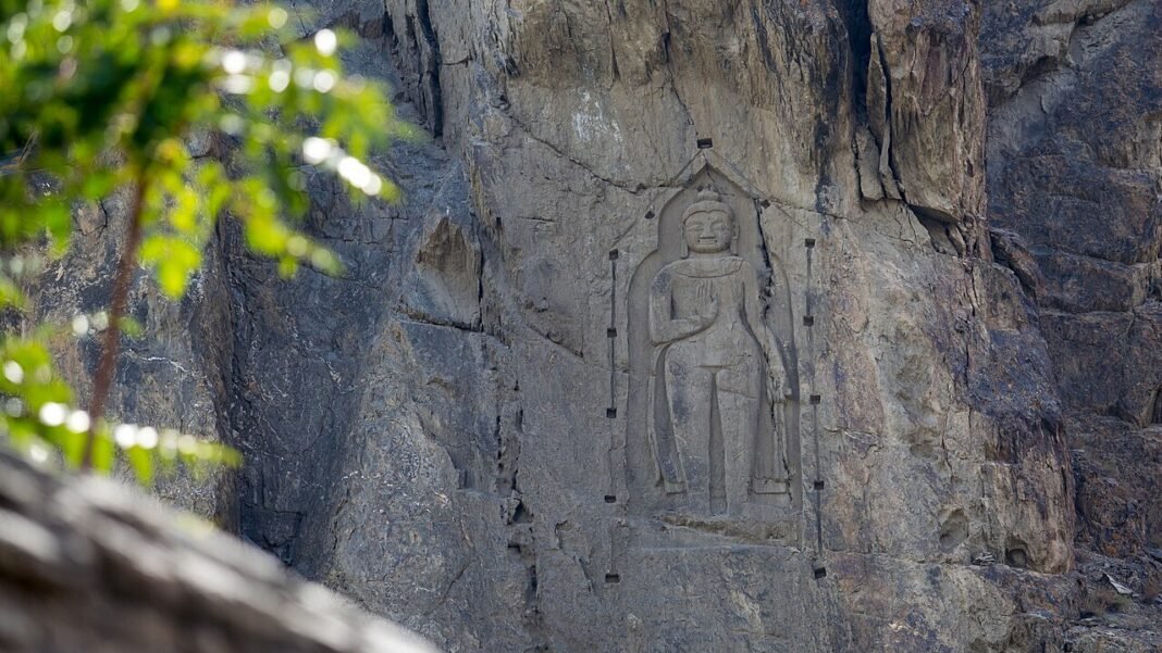
The Kargah Buddha is worth the trip on its own. Carved into a rock cliff about nine kilometers from the city at the junction of the Kargah and Shukogah streams, this 7th-century Buddha figure — called Yashani in the local language — has watched over travelers for thirteen centuries. Getting there is half the adventure, and standing before it connects you directly to the Buddhist caravans that once crossed these mountains carrying scriptures and silk between South Asia and Central Asia.
Gilgit also works brilliantly as a logistics base. Unlike the more touristed valleys, it has real infrastructure: a proper bazaar, banks, hospitals, tour operators, equipment shops, and transport connections in every direction. Trekkers heading for the Baltoro, Biafo, or the great peaks of the Karakoram stage here. Families can use it as a comfortable, lower-altitude first stop before ascending to Hunza or Skardu, which helps with acclimatization. And the food scene — chapshuro sizzling on griddles, salted buza tea, bowls of dried apricots — is a genuine taste of mountain culture rather than a performance for tourists.
Honest note: Gilgit is a working administrative city, not a postcard village. It will not give you the manicured charm of Karimabad. What it gives you instead is authenticity — a real mountain city living its real life, with history you can touch and mountains that need no filter. For travelers building a serious northern Pakistan itinerary in the Explore Pakistan spirit, Gilgit is the foundation everything else is built on.
History of Gilgit
Gilgit’s history stretches back to the Silk Road era, when it was an important city on the route along which Buddhism spread from South Asia into Central Asia. The earliest known mention of the city’s name comes from the Hatun Rock Inscription, dating to the 7th century CE, which records it as “Giligitta.” Two of history’s most famous Buddhist pilgrims — the Chinese monks Faxian and Xuanzang — traversed Gilgit on their journeys, and archaeological evidence shows the city was a Buddhist center from roughly the 3rd to the 11th century.
The most extraordinary chapter of that Buddhist past was written in 1931, when a trove of Sanskrit Buddhist manuscripts was discovered at Naupur near Gilgit. Dating between the 2nd and 8th centuries CE, the Gilgit manuscripts are among the most important Buddhist texts ever found, preserving scriptures that had been lost elsewhere. A monastery and three stupas containing more manuscripts were excavated nearby in the 1930s, confirming that Gilgit hosted a thriving monastic community. The Kargah Buddha, carved around the 7th century, belongs to this same world — rock carvings and inscriptions from the pre-Islamic period are scattered across the region at Shaital, Thor, Thalpan, and Chilas.
Political power in the valley passed through many hands. The Palola Shahi kingdom ruled here in the early centuries CE, leaving behind carved lion thrones and Buddhist art. Over the centuries the valley’s rulers — the Trakhane dynasty and later the local rajas — controlled the strategic corridor between the Indus plains and the high passes. Islam arrived gradually and the region’s Buddhist identity faded, but the carvings remained, half-forgotten on cliff faces.
In the 19th century, Gilgit became a pawn in the Great Game. The British established the Gilgit Agency in 1877 to watch the northern frontier, and the valley passed under Dogra rule from Kashmir. In November 1947, following the partition of British India, Gilgit acceded to Pakistan. The construction of the Karakoram Highway through the 1960s and 1970s — often called the eighth wonder of the world — transformed Gilgit from a remote garrison town into the bustling mountain capital it is today, connected by road to Kashgar in China and by air to Islamabad.
Top Things to Do in Gilgit
Visit the Kargah Buddha
The 7th-century Buddha carved into the cliff at the mouth of the Kargah nullah is Gilgit’s single most important historical site. The figure, some nine kilometers from the city center, sits at the junction of the Kargah and Shukogah rivulets near the villages of Barmas and Napura. Locally known as Yashani, it drew Buddhist pilgrims and traders for centuries. The road to the site has been rough in recent years, so go with a local driver and allow half a day.
Explore the Old Bazaar
Gilgit’s bazaar is the commercial heart of the entire region — this is where mountaineers buy last-minute gear, where dried apricots and walnuts arrive from a hundred villages, and where gemstones from the surrounding mines change hands. Wander without an agenda, drink chai with shopkeepers, and watch a real mountain economy at work.
Watch Polo at the Local Ground
Polo is the traditional sport of Gilgit-Baltistan, played here in a fast, rugged local style long before the famous Shandur festival. Matches at Gilgit’s polo ground, especially around festival times, are loud, thrilling, and completely authentic — horsemen, drums, and crowds that take the game very seriously.
Day Trip to Naltar Valley
About 35-40 km from Gilgit, Naltar is a pine-forested valley with glacial lakes, ski slopes (Pakistan’s main ski facility operates here in winter), and meadows framed by high peaks. The jeep road up is an adventure in itself. It is the easiest spectacular day trip from the city.
See the River Confluence
Just outside the city, the Gilgit River meets the Indus — and nearby, the three great ranges (Karakoram, Himalaya, Hindu Kush) converge. The viewpoint where the rivers join is a classic stop, especially at golden hour when the water turns silver and the peaks glow.
Trace the Buddhist Past at Naupur
Visit the area around Naupur where the Gilgit manuscripts were discovered in 1931 and where a monastery and stupas were excavated in the 1930s. Little is developed for tourism, but for history lovers, standing where those manuscripts slept for a thousand years is quietly moving.
Famous Places In and Around Gilgit
- Hunza Valley: 2-3 hours north on the KKH — Karimabad, Baltit and Altit forts, Attabad Lake. Start with our Attabad Lake guide and Baltit Fort guide.
- Fairy Meadows: reached via Raikot on the KKH, the famous meadow beneath Nanga Parbat’s Raikot face.
- Skardu: east along the Indus valley road — the gateway to the Baltoro and K2.
- Chitral: west over the Shandur Pass — Kalash valleys and the Shandur polo ground.
- Bagrote Valley: a quieter valley near Gilgit with glaciers and traditional villages.
- Phandar and Ghizer: west toward Shandur, with lakes and green valleys.
How to Reach Gilgit
Route Details
- From Islamabad (around 480-500 km, 10-14 hours): The classic route follows the Karakoram Highway via Mansehra, Battagram, Besham, Dasu, and Chilas. The road is paved but winding, with landslide-prone sections — check conditions before departing, especially in monsoon season and winter. Many travelers break the journey overnight in Besham or Chilas.
- From Lahore (around 700 km, 16-18 hours): Take the motorway to Islamabad/Rawalpindi, then join the KKH. Most travelers do this in two days with a night stop.
- From Karachi (around 1,750 km): Fly to Islamabad first — the road journey from Karachi is a multi-day expedition best attempted only by experienced road-trippers.
- By air: PIA operates flights from Islamabad to Gilgit Airport (around one hour), offering staggering aerial views of the Karakoram. Flights are strictly weather-dependent and cancellations are common, especially in winter — always keep a buffer day and a road backup plan.
- By bus/van: NATCO and private operators run coaches and vans from Rawalpindi/Islamabad and Lahore to Gilgit. It is economical but slow given the mountain terrain.
Road conditions on the KKH vary by season: summer brings the risk of landslides and glacial lake outburst floods in some sections, while winter can close high stretches with snow. The Gilgit-Skardu road and the Gilgit-Hunza road are both paved and in much better shape than they once were. For onward travel to valleys like Naltar, hire a 4×4 jeep with a local driver.
Where to Stay in Gilgit
Gilgit has the widest range of accommodation in the region. At the top end, there are comfortable hotels with mountain views, hot water, and reliable Wi-Fi catering to foreign trekkers and tour groups. Mid-range hotels cluster around the city center and the airport road — clean, heated in winter, and good value. Budget guesthouses and backpacker lodges serve trekkers and domestic tourists. Because Gilgit is a real city rather than a seasonal resort town, most places stay open year-round, though heating matters enormously from November to March — confirm it before booking. If you are acclimatizing before heading higher, plan at least two nights here; your body will thank you when you reach Hunza or Skardu.
Where to Eat: Local Foods of Gilgit
Gilgit’s food is mountain food — hearty, warming, and built around wheat, meat, dairy, and dried fruit. The signature dish is chapshuro, a spiced meat-filled pastry fried on a griddle and sold piping hot in the bazaar. Buza, the strong salted milk tea, is the local drink of choice and an acquired taste worth acquiring. Dried apricots are everywhere — eaten as snacks, pressed into oil, and juiced fresh in season. You will also find trout from the cold streams, walnut cake, mulberry juice in summer, and hearty daal and roti at every dhaba. A filling bazaar meal is budget-friendly; restaurant dinners cost modestly more. For the freshest apricot juice of your life, come in July and August.
Weather in Gilgit
Gilgit has a dry mountain climate with sharp seasonal contrasts — warm summers, cold winters, and relatively little rain. At around 1,500 meters, it escapes both the plains’ brutal heat and the extreme cold of the higher valleys, which is why it works as a year-round administrative capital even though tourism is seasonal.
| Season | Temperature Range | Conditions |
|---|---|---|
| Winter (Dec-Feb) | -3°C to 10°C | Cold nights, crisp sunny days; occasional snow in the city, heavy snow on the passes; some routes close |
| Spring (Mar-May) | 7°C to 28°C | Blossom season in late March-April; warming days, cool nights; occasional spring showers |
| Summer (Jun-Sep) | 18°C to 36°C | Warm, dry, and sunny with long daylight; peak trekking and travel season; July is the hottest month |
| Autumn (Oct-Nov) | 5°C to 22°C | Crisp air, golden poplar and apricot trees; spectacular colors; cooling fast by November |
Language and Culture of Gilgit
The main language of Gilgit city is Shina, with Burushaski and Wakhi spoken by smaller communities and Urdu and English widely understood, especially in tourism. The population is predominantly Muslim with a mix of Sunni and Shia communities living side by side. Mountain hospitality is real here — guests are treated with genuine warmth — but it comes with expectations: dress modestly, ask before photographing people (especially women), and respect prayer times and religious sites. Bargaining in the bazaar is normal and good-natured. If you are invited for chai, accept — some of the best travel stories in Gilgit-Baltistan begin with an unplanned cup of tea.
Shopping in Gilgit
Gilgit’s bazaar is the best-stocked market in the region for mountain goods. Dried apricots, apricot oil, walnuts, and mulberries are the classic edible souvenirs — buy them from the old bazaar where the turnover is fast and the quality high. The region’s gemstones (aquamarine, topaz, tourmaline) are sold in gem shops, but buy only from reputable dealers and get a certificate for anything expensive. Woolen shawls, caps, and handicrafts from Hunza and Ghizer appear in the craft shops. There is no modern shopping mall culture here; the bazaar is the mall, and it is far more interesting.
Local Events and Festivals
Navroz (March 21): The Persian New Year is celebrated across Gilgit-Baltistan with traditional music, dancing, and special foods — spring’s arrival in the mountains is a genuine cause for celebration after the long winter.
Shandur Polo Festival (July): Held at the Shandur Pass between Gilgit-Baltistan and Chitral, this is the world’s highest polo tournament, played on the legendary Shandur ground at around 3,700 meters. Teams from Gilgit and Chitral compete in a fierce, historic rivalry, with folk music, dancing, and camping under the stars. It is a few hours from Gilgit city but many visitors base themselves in Gilgit for the event.
Harvest season (September-October): While not a single formal festival, the fruit harvest brings a festive atmosphere to the whole region, with fresh produce, local fairs, and the famous autumn colors.
Travel Tips for Gilgit
Packing Essentials
Layers are everything: even in summer, evenings cool down fast. Bring a warm jacket, sun protection (the mountain sun is fierce), sturdy walking shoes, a refillable water bottle, and any medications — pharmacies exist in the city but specialized items may not. If trekking, bring or rent proper gear; Gilgit has equipment shops but selection varies.
Safety Tips
Gilgit is generally safe for tourists and the tourism infrastructure is well established. The main risks are environmental, not criminal: altitude (acclimatize before heading higher), road conditions on mountain highways, and weather changes. Hire local drivers for mountain roads, never drive the KKH at night, and register with your tour operator or hotel when heading into remote valleys.
Money & Connectivity
Banks and ATMs are available in Gilgit city — withdraw cash here before heading to smaller valleys where ATMs are scarce. Mobile signals work in the city (Jazz/Telenor and SCOM, the local operator, have the best mountain coverage), but expect dead zones on the highways and in side valleys. Wi-Fi is available at most hotels.
Best Time to Visit Gilgit
Spring (late March to May) — blossom season
Late March to mid-April brings the famous apricot and cherry blossom — the valleys turn white and pink against the brown mountains. Temperatures are mild, crowds are thinner than summer, and photographers consider this one of the two finest seasons.
Summer (June to September) — peak season
Warm, dry, and sunny with up to 14 hours of daylight — this is trekking season and the only time the high passes and meadows are fully accessible. July and August are the busiest months; book accommodation ahead. This is the season for Fairy Meadows, Naltar’s lakes, and onward travel to Hunza and Skardu.
Autumn (October to early November) — golden season
Many seasoned travelers call this the best time of all: crisp air, golden poplars and apricot orchards, clear mountain views, and fewer tourists. By mid-November the cold sets in and the season winds down.
Winter (December to February) — for the hardy
Heavy snow closes many routes and flights become unreliable, but the city itself is starkly beautiful and Naltar offers skiing. Only for travelers who are prepared for real mountain winter and flexible plans.
Final Thoughts
Gilgit rewards the traveler who slows down. It is easy to treat it as a fuel stop on the way to Hunza’s postcard valleys, but the city holds thirteen centuries of Silk Road history in its cliffs and bazaars — a 7th-century Buddha, the manuscripts that rewrote Buddhist scholarship, and a living mountain culture that predates every guidebook. Give it two or three days: one for the Kargah Buddha and the old city, one for Naltar, and one for doing nothing but drinking buza and watching the light change on the peaks.
Then, when you finally continue north to Hunza or east toward Skardu, you will travel with context — understanding the mountains not just as scenery but as a corridor that has carried faith, trade, and stories for two thousand years. That is the difference between passing through Gilgit and visiting it.
FAQs
Where is Gilgit located?
Gilgit is the capital city of Gilgit-Baltistan in northern Pakistan, located near the confluence of the Gilgit and Hunza rivers at around 1,500 meters altitude, on the Karakoram Highway.
What is the best time to visit Gilgit?
May to October is the main season, with warm dry weather ideal for sightseeing and trekking. Late March to April brings blossom season, and October to early November offers spectacular autumn colors.
How do I reach Gilgit from Islamabad?
Either fly with PIA from Islamabad to Gilgit Airport (about one hour, weather permitting) or drive the Karakoram Highway (around 480-500 km, 10-14 hours). Flights are often cancelled in bad weather, so keep a buffer day.
What is the Kargah Buddha?
A 7th-century Buddha figure carved into a rock cliff about 9 km from Gilgit city, at the junction of the Kargah and Shukogah streams. It is the most important Buddhist relic in the area, from the era when Gilgit was a major Buddhist center.
Is Gilgit safe for tourists?
Yes, Gilgit has well-established tourism infrastructure and is generally safe for visitors. Take normal mountain precautions: acclimatize, hire local drivers for mountain roads, and avoid night driving on the KKH.
Is Gilgit suitable for families?
Yes. At 1,500 meters it is a comfortable altitude, with good hotels, hospitals, restaurants, and easy day trips like Naltar Valley and the Kargah Buddha. It is an ideal first stop for families acclimatizing before higher valleys.
Where should I stay in Gilgit?
Gilgit has the widest accommodation range in the region, from comfortable trekker-oriented hotels to mid-range city hotels and budget guesthouses. Confirm heating for winter stays.
What local food should I try in Gilgit?
Chapshuro (spiced meat pastry), buza (salted milk tea), dried apricots and fresh apricot juice in summer, trout, and walnut cake.
What is Gilgit famous for historically?
Its Silk Road and Buddhist heritage: the 7th-century Kargah Buddha, the Gilgit manuscripts discovered in 1931 (2nd-8th century Sanskrit Buddhist texts), and visits by the Chinese pilgrims Faxian and Xuanzang.
Can I visit Hunza and Skardu from Gilgit?
Easily — Gilgit is the transport hub for both. Hunza is 2-3 hours north on the KKH, and Skardu is a day’s drive east along the Indus. See our Aliabad Hunza guide to plan the onward journey.