Some valleys you visit for comfort. Haramosh is not one of them — and that is exactly why it stays with you. Tucked into the Karakoram east of Gilgit, beneath a 7,409-meter giant that has defeated almost every climber who ever challenged it, Haramosh is raw, remote, and ridiculously beautiful: pine forests, glaciers, waterfalls, and meadows with views of Nanga Parbat on the horizon. If you have already done Hunza and Skardu and you are hungry for the Pakistan that tourists have not found yet, this Haramosh travel guide is your invitation.
This guide covers why Haramosh deserves your trip, who it is perfect for, and when to go — plus the real story of the peak, the top things to do from Kutwal Lake to Khun Meadows, how to reach the valley from Islamabad, Lahore, and Karachi, where to stay, what to eat, and essential safety advice for one of the Karakoram’s wildest corners. Haramosh is an adventure, not a picnic. Come prepared, and it will give you the journey of a lifetime.
Quick Facts
- Location: Gilgit District, Gilgit-Baltistan, Pakistan — the valley runs south of the Gilgit–Skardu road, beneath Haramosh Peak in the Karakoram
- Altitude: Dache (Dassu) village sits at around 2,400 meters; Kutwal village and the upper valley are higher
- Famous For: Haramosh Peak (7,409 m), one of the least-climbed 7,000-meter peaks on earth; Kutwal Valley and Kutwal Lake; Khun Meadows; the dramatic jeep track from Sassi
- Nearest City: Gilgit (the Sassi turnoff is about 53 km from Gilgit on the Jaglot–Skardu road)
- Accessibility: Adventurous — 4×4 jeep track from Sassi to Dache, then trekking on foot; not suitable for ordinary cars or casual sightseeing
- Known Landmarks: Haramosh Peak, Kutwal Lake, Khun Meadows, the Seven Waterfalls viewpoint, Baska Glacier, Rakhan Pass (linking Bagrot Valley)
- Best For: Trekkers, mountaineers, adventure travelers, photographers, and experienced northern-areas explorers seeking uncrowded wilderness
Why Visit Haramosh
Let us be honest first: Haramosh is not for everyone. The road in is a narrow jeep track with drops that make even seasoned travelers grip their seats. There are no hotels, no restaurants, no souvenir shops. The weather can turn in an hour, and the nearest proper hospital is back in Gilgit. If that paragraph scared you, Haramosh is not your destination — and there is no shame in that.
But if that paragraph excited you, keep reading, because Haramosh is one of the great unsung adventures of the Karakoram. This is a valley that mass tourism has simply never reached. While thousands crowd the viewpoints of Hunza each summer, Haramosh’s trails see a trickle of trekkers, most of them bound for serious objectives. The result is a wilderness experience that is getting harder to find anywhere in the mountains of Pakistan: pine forests you walk through alone, glaciers you hear before you see, and meadows where the only sounds are wind, water, and your own breathing.
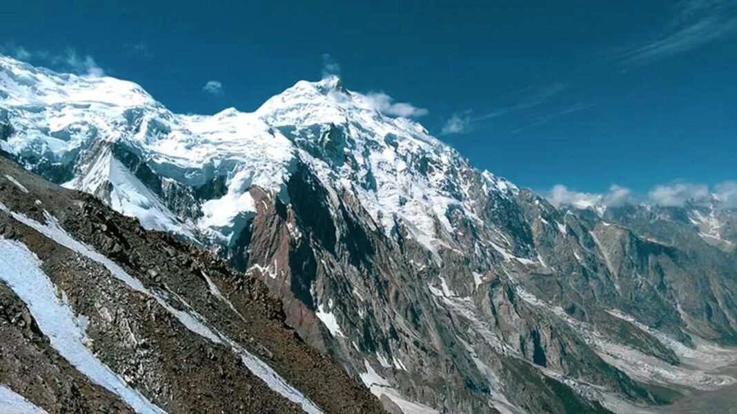
The scenery is the headline act. Haramosh Peak itself — 7,409 meters of steep rock and ice rising above the Indus — dominates the valley, and it is a mountain with a fearsome reputation: first climbed in 1958, it has seen only a handful of successful ascents since. Around it cluster more giants: Malubiting (7,458 m), Miar Peak, and the fabled Bilchar Dobani. From Khun Meadows, on a clear day, you can even see Nanga Parbat (8,126 m) on the horizon — a view that stitches together three of the Karakoram and Himalaya’s greatest mountains in a single panorama. Add the Seven Waterfalls viewpoint, the blue-green Kutwal Lake, and the Baska Glacier, and you have a trekker’s dreamscape.
Haramosh is also a journey into a living mountain culture. The valley’s villages — Dache, Kutwal, Khaltaro, Khaya — are home to Shina-speaking farming communities who grow wheat, potatoes, and apricots on terraced fields and have welcomed the rare trekker for generations. The valley’s population is around eight thousand people, and their hospitality to those who make the effort to come is genuine. For the well-prepared traveler, Haramosh offers what the famous valleys increasingly cannot: solitude, challenge, and the feeling of discovering something. Pair this trip with our Bagrot Valley guide — the neighboring valley, linked to Haramosh by the high Rakhan Pass — or start your northern journey with our Gilgit travel guide.
History of Haramosh
Unlike the ancient cities of the plains, Haramosh has no recorded kings or excavated ruins. Its history is the history of the Karakoram itself: a remote valley of herders and farmers, known to the outside world mainly through the mountain that towers over it — and the climbers who came to challenge that mountain.
Haramosh Peak, also known simply as Haramosh or “Peak 58,” rises to 7,409 meters (24,308 feet) in the Rakaposhi-Haramosh subrange of the Karakoram, roughly 65 kilometers east of Gilgit. It stands steeply above the north bank of the Indus River, just upstream from where the Gilgit River joins it. The massif has two main summits: Haramosh Peak itself and the Haramosh Kutwal Laila Peak. For mountaineers, it has always been a prize wrapped in a warning: technically demanding, remote, and cursed with unpredictable weather.
The mountain’s climbing history began in tragedy. A 1957 British expedition ended in disaster on Haramosh’s slopes, a story immortalized in Ralph Barker’s classic mountaineering book The Last Blue Mountain — one of the great tragedies of Himalayan climbing literature. The peak was finally conquered on 4 August 1958 by an Austrian team — Heinrich Roiss, Stefan Pauer, and Franz Mandl — who reached the summit via the Haramosh La and the East Ridge. It remains one of the least-climbed 7,000-meter peaks in the Karakoram; the record books show only a scattering of later ascents (a Japanese team in 1978, a Polish team in 1988, and a few others), a testament to the mountain’s remoteness and difficulty.
For the valley below, the modern era arrived with the road. The jeep track from Sassi — the settlement on the Jaglot–Skardu road where the Haramosh route begins — opened the valley to trekkers and to the outside world, though “opened” is a generous word for one of the hairiest tracks in Gilgit-Baltistan. In recent years, vloggers and trekking groups have begun to publicize the valley’s beauty — Kutwal Lake, Khun Meadows, the waterfalls — and a slow trickle of domestic adventure tourists has followed. Haramosh today stands at a crossroads familiar to many Karakoram valleys: still wild, still demanding, but no longer entirely unknown. Go now, while it is still itself.
Top Things to Do in Haramosh
Trek to Kutwal Village and Kutwal Lake
The classic Haramosh journey: from Dache (Dassu), at around 2,400 meters, trek up the valley past the settlement of Mani and alongside the Baska Glacier to Kutwal village — a strenuous two-day walk through pine forest and alpine pasture. Above the village lies Kutwal Lake, a high mountain lake cradled beneath the Haramosh massif. The lake’s still waters reflecting the 7,409-meter peak is one of the great images of the Karakoram, and reaching it feels like a genuine expedition achievement. This trek requires fitness, proper gear, and ideally a local guide — the trail is unmarked in places and glacier travel demands respect.
Khun Meadows and the Seven Waterfalls
On the Khaltaro side of the valley, the trail climbs from Khaltaro village through Khaya, Kalijut, and Pamiri to the Seven Waterfalls viewpoint, where as many as seven cascades can be seen at once, with the larger Saral waterfall across the valley. Beyond lies Khun Meadows, a vast green alp with one of the finest panoramas in Gilgit-Baltistan: Nanga Parbat, Malubiting, Haramosh Peak, Miar Peak, and Bilchar Dobani in a single sweeping view. Trekkers call it the valley’s best-kept secret, and on a clear summer morning it is pure magic. The Khaltaro jeep track itself is famously hair-raising — a two-hour narrow off-road climb that makes the Fairy Meadows track look tame, according to those who have done both.
Base Yourself for Haramosh Peak Views
You do not need to climb 7,409 meters to experience the mountain. The trekking routes through the valley offer ever-closer views of Haramosh’s steep faces and hanging glaciers, and simply camping beneath a peak that has defeated almost every expedition in history is a humbling experience. Photographers: the golden light on Haramosh’s east face at sunrise is extraordinary, and the massif photographs dramatically from the upper meadows. For the full story of the neighboring giant, see our Bagrot Valley guide, from whose Gasunar pastures the Rakhan Pass trail sets out for Haramosh.
Cross the Rakhan Pass from Bagrot
For serious trekkers, the ultimate Haramosh approach is the Rakhan Pass (around 5,400 meters), which links Bagrot Valley’s Gasunar pastures with Haramosh — a tough two-day high crossing between two of Gilgit’s wildest valleys. This is expedition-grade trekking: high altitude, glacier travel, and no facilities. Only attempt it with an experienced local guide, proper acclimatization, and full high-mountain gear. Those who complete it join a very small club.
Experience Village Life in Dache and Khaltaro
Slow down in the valley’s villages. Dache (Dassu), Khaltaro, and the smaller hamlets are working farming communities — terraced wheat and potato fields, apricot orchards, and stone-and-timber houses. Walk the village lanes, accept the inevitable invitation to tea, and learn how mountain life works at 2,400 meters. The people of Haramosh see few visitors, and their welcome is correspondingly warm. Bring small gifts for children (school supplies are appreciated more than sweets) and always ask before photographing people.
Famous Places In and Around Haramosh
Haramosh Peak (7,409 m) — the valley’s towering, rarely climbed giant. Kutwal Lake — the high lake beneath the massif. Khun Meadows — panoramic alp with Nanga Parbat views. Seven Waterfalls viewpoint — Khaltaro side cascades. Baska Glacier — the valley glacier on the Kutwal route. Rakhan Pass — the high link to Bagrot Valley. Sassi — the roadside settlement where the Haramosh track begins. Gilgit — the gateway city, about 53 km from Sassi, for supplies, guides, and transport.
How to Reach Haramosh
Reaching Haramosh is a two-stage journey: first get to Gilgit, then take the jeep track into the valley. There are no shortcuts, and the second stage demands a proper 4×4 and a steady nerve.
From Islamabad to Gilgit (about 480 km, 10–12 hours by road): The classic route is the Karakoram Highway (N-35) via Mansehra, Besham, and Chilas — a long but spectacular drive. In summer (roughly June to September), the shorter Babusar Pass route via Naran cuts the journey significantly when the pass is open. Alternatively, fly: PIA operates flights from Islamabad to Gilgit, but they are weather-dependent and frequently cancelled — never plan a tight itinerary around them. Most travelers break the road journey overnight in Besham or Chilas.
From Lahore to Gilgit (about 900 km, 16–18 hours): Drive to Islamabad first (M-2, about 4.5 hours), then continue as above. Given the distance, almost everyone overnights en route or flies to Islamabad and continues by road or air.
From Karachi to Gilgit (about 2,000 km): Do not drive this unless you are on a grand overland expedition. Fly Karachi to Islamabad, then continue to Gilgit by road or PIA flight.
Gilgit to Haramosh: From Gilgit, take the Jaglot–Skardu road (S-1) east to Sassi, about 53 km. At Sassi, the Haramosh jeep track branches off — a rough, narrow mountain track climbing to Dache (Dassu) village at around 2,400 meters, about an hour of white-knuckle driving. From Dache, you continue on foot: the trek to Kutwal village takes about two days via Mani and the Baska Glacier. For the Khaltaro side, a separate jeep track climbs from Sassi to Khaltaro village (about two hours), and the trekking routes to Khun Meadows begin there. Hire jeeps and guides in Gilgit or Sassi; do not attempt these tracks in an ordinary car, and do not attempt them at all in winter or during heavy rain.
Route Details
Step by step: (1) Reach Gilgit by road (KKH or Babusar) or PIA flight from Islamabad. (2) Arrange a 4×4 jeep and, strongly recommended, a local guide in Gilgit — confirm fuel, spares, and return pickup. (3) Drive the Jaglot–Skardu road to Sassi (53 km, about 1.5 hours). (4) Turn onto the Haramosh jeep track; Dache is about an hour ahead — expect landslides and rockfall sections, and go only in daylight. (5) From Dache, trek: Day 1 to the Mani area through pine forest; Day 2 across to Kutwal village via the Baska Glacier approach; Kutwal Lake is a further push above the village. (6) For Khaltaro/Khun Meadows: jeep Sassi to Khaltaro (about 2 hours), then trek via Khaya and Kalijut to the waterfalls viewpoint and Khun Meadows. Carry all food, fuel, and camping gear — there are no shops beyond the villages, and no medical facilities in the valley.
Where to Stay in Haramosh
Be clear about this: there are no hotels in Haramosh Valley. Accommodation here means camping and village hospitality. Trekkers carry full camping gear — four-season tent, warm sleeping bag, cooking equipment — and camp at Dache, Kutwal, and the meadow campsites. In the villages, local families sometimes host trekkers in spare rooms or guest space; arrange this through your guide, offer fair payment, and respect household customs. Your real “hotel nights” will be in Gilgit before and after the trek, where the city has the full range from budget guesthouses to comfortable mid-range hotels — stock up there on supplies, cash, and any gear you are missing. Do not plan to buy anything beyond basic village provisions once you leave Sassi. For trekkers crossing from Bagrot, the same applies in reverse: sleep in Gilgit or Bagrot’s villages, camp in between.
Where to Eat: Local Foods of Haramosh
You eat what you carry, plus what the valley offers. On the trek, bring all your own food from Gilgit — high-energy staples: rice, lentils, pasta, dried fruits, nuts, energy bars, tea, and sugar. In the villages, you may be offered the local mountain diet, and you should accept with gratitude: chapshuro (the savory meat-filled flatbread of Gilgit-Baltistan), buckwheat pancakes, hearty potato and wheat dishes from the terraced fields, and endless cups of namkeen chai (salt tea), the region’s staple brew. Dried apricots — the valley and its neighbors produce superb ones — are the perfect trail snack, and fresh apricots in July–August are a joy. In Gilgit before and after, eat well: the city’s restaurants serve chapshuro, mamtu (steamed dumplings), trout from the mountain rivers (where available), and standard Pakistani-Chinese restaurant fare. There are no restaurants, dhabas, or food streets in Haramosh Valley itself — plan every meal in advance and carry more food than you think you need.
Weather in Haramosh
Haramosh is a high Karakoram valley, and its weather is serious mountain weather: short summers, long snowbound winters, and rapid changes at any time. The trekking season is effectively June to September; outside these months the jeep tracks are dangerous or impassable and the upper valley is under deep snow. Even in summer, carry clothing for near-freezing nights at the higher camps.
| Season | Temperature Range (valley floor, ~2,400 m) | Conditions |
|---|---|---|
| Winter (Dec–Feb) | -15 to -2°C | Deep snow; valley largely cut off. No tourism — do not attempt. |
| Spring (Mar–May) | -5 to 12°C | Snowmelt, landslide risk on tracks, streams in flood. Late May opens lower trails. |
| Summer (Jun–Sep) | 8 to 20°C | The season. Long days, accessible tracks, green meadows. Afternoon clouds and rain possible. |
| Autumn (Oct–Nov) | -8 to 10°C | Golden colors, then rapid onset of winter. Early October possible; November too risky. |
At Khun Meadows and the higher camps, subtract roughly 5–8°C from valley-floor temperatures. Weather in the Karakoram can change within hours — a clear morning can become a snowstorm by afternoon above 3,500 meters. Check forecasts in Gilgit before setting out, and build spare days into your itinerary.
Language and Culture of Haramosh
The people of Haramosh Valley speak Shina, the main language of the Gilgit area, with Urdu understood by many younger people and those who deal with visitors. The valley’s communities are Muslim, and village life follows the rhythms of farming, herding, and the seasons that have shaped it for centuries. Around eight thousand people live in the valley’s scattered villages.
For visitors, the cultural notes are those of any remote mountain community in Gilgit-Baltistan, amplified by the valley’s isolation: dress modestly (long trousers and covered shoulders for everyone; women should carry a headscarf for village visits), always ask before photographing people — especially women — and accept hospitality graciously when it is offered. If you are hosted in a home, follow your guide’s lead on customs, remove shoes where indicated, and offer fair payment for food and lodging rather than assuming generosity is free. During Ramadan, be discreet about eating and drinking in villages during daylight. The valley’s remoteness means your behavior will be remembered — leave a good impression for the trekkers who come after you.
Shopping in Haramosh
There is nothing to buy in Haramosh Valley, and that is fine — it is not that kind of place. Do your shopping in Gilgit before you set out: the city’s bazaars are excellent for authentic Karakoram souvenirs, including dried apricots, almonds, and walnuts from the surrounding valleys, handwoven woolen shawls and caps, local handicrafts, and apricot oil, a prized local product. Trekking supplies — gas canisters, batteries, basic gear — are also available in Gilgit’s markets, though selection is limited compared to Islamabad, so bring specialist equipment with you. There are no malls, boutiques, or souvenir shops anywhere in the Haramosh Valley itself.
Local Events and Festivals
Haramosh has no festival of its own, but it shares in the great celebrations of Gilgit-Baltistan. Navroz (around March 21), the Persian New Year marking the spring equinox, is celebrated enthusiastically across the region with traditional foods, music, and community gatherings — though March is far too early for trekking in Haramosh itself, the festival colors Gilgit beautifully if your trip coincides. The two Eids are the valley’s main religious celebrations, observed in the villages with prayers, feasts, and visiting between families; an Eid visit offers warm cultural immersion but requires arranging hospitality well in advance, as transport and supplies are stretched. Beyond these, the valley’s calendar is the agricultural one — sowing, harvest, and the movement of livestock to summer pastures — and simply being there for it is event enough.
Travel Tips for Haramosh
Packing Essentials
Pack like the valley is trying to test you, because it is. Four-season tent, sleeping bag rated well below freezing, insulated mat, and cooking gear — there is no resupply. Layered clothing: thermal base layers, fleece, waterproof shell jacket and trousers, warm hat, gloves, and sturdy broken-in trekking boots with ankle support. Sun protection is critical at altitude: glacier glasses or high-protection sunglasses, strong sunscreen, lip balm. A comprehensive first-aid kit including altitude-sickness medication (consult your doctor), water purification (filter or tablets), headlamp with spare batteries, trekking poles, and a satellite communicator or personal locator beacon — there is no mobile signal in the upper valley. Carry all food from Gilgit plus two days’ reserve. And cash: no ATMs, no card payments, anywhere in the valley.
Safety Tips
Haramosh demands more safety planning than any other destination in this guide series. Hire a local guide — non-negotiable for the Kutwal trek or Rakhan Pass; the trails are unmarked in places and glacier crossings are dangerous without local knowledge. Acclimatize: spend at least a night or two in Gilgit (1,500 m) before heading up, ascend gradually, and know the symptoms of altitude sickness. Never travel the jeep tracks after dark or in rain — landslides are the valley’s biggest killer, and the Sassi–Dache and Sassi–Khaltaro tracks have sheer drops. Register your plans: leave your itinerary and expected return date with your hotel in Gilgit and your guide’s family. Weather: turn back if conditions deteriorate; the mountain will be there next year. There are no medical facilities in the valley — the nearest hospital is in Gilgit, hours away on a good day. Travel insurance with helicopter evacuation cover is strongly advised for trekkers.
Money & Connectivity
Cash only, and bring plenty: withdraw in Gilgit (or Islamabad/Lahore before you fly north), because there are no ATMs beyond Gilgit and no digital payments in the valley. Budget for jeep hire, guide fees, porters if needed, village hospitality payments, and contingency days. Mobile signals from all networks fade soon after Sassi and vanish entirely in the upper valley — tell family you will be out of contact, agree check-in times for your return to Gilgit, and consider renting a satellite communicator in Islamabad for longer treks. Zong and SCOM generally have the best northern coverage where any signal exists.
Best Time to Visit Haramosh
Summer (June to September) — The Only Real Season
This is when Haramosh is open for business. The jeep tracks are passable, the trails are clear of winter snow, the meadows are green, and daytime temperatures on the valley floor reach a pleasant 15–20°C. July and August are the peak: warmest weather, apricots ripening in the villages, and the most reliable track conditions — but also the highest (still modest) number of fellow trekkers and the greatest chance of afternoon cloudbursts. June and September are the connoisseur’s choice: fewer people, crisp clear air, and superb mountain views, with September bringing golden autumn colors to the lower valley. Nights are cold at altitude in every month — pack for freezing temperatures at the high camps even in August.
Spring (April to May) — Too Early
The valley wakes up, but the tracks are at their most dangerous: snowmelt swells the streams, and landslides are frequent. Lower villages become reachable in late May, but the upper valley and Kutwal remain snowbound. Not recommended for trekking.
Autumn (October) — A Narrow Window
Early October can be magnificent — clear skies, golden poplars and apricot trees, empty trails — but the window slams shut fast. By late October, snow returns to the high passes and the jeep tracks become risky. Only attempt with flexible plans and a willingness to turn back.
Winter (November to March) — Closed
Deep snow, extreme cold, and no access. The valley’s villages endure the winter in isolation; visitors should not attempt to join them. Plan for summer instead.
Final Thoughts
Haramosh is not the easiest destination in Pakistan, nor the most comfortable, nor the most famous. It is something better: one of the last truly wild valleys of the Karakoram, where a 7,409-meter giant still turns back almost everyone who challenges it, where meadows look out on Nanga Parbat, and where the trekker you pass on the trail might be the only other visitor that week. It asks a lot — fitness, preparation, humility — and it repays with interest.
If your heart beats faster at the thought of the jeep track from Sassi, the pine forests above Dache, and Kutwal Lake shining beneath Haramosh Peak, then this valley is calling you. Prepare thoroughly, hire a good local guide, respect the mountain weather, and go in July, August, or September. And when you are back in Gilgit with dust on your boots and the Karakoram in your camera, you will understand why the few who know Haramosh guard its secret so carefully. For gentler northern adventures afterward, our Malam Jabba guide and Hunza Valley guide await.
FAQs
Where is Haramosh located?
Haramosh is a valley in Gilgit District, Gilgit-Baltistan, beneath Haramosh Peak (7,409 m) in the Karakoram. The valley is reached via a jeep track from Sassi, a settlement about 53 km from Gilgit on the Jaglot–Skardu road.
What is the best time to visit Haramosh?
June to September is the only practical season, with July–August the peak and June/September offering clearer air and fewer people. The valley is snowbound and inaccessible from roughly November to March.
How do I reach Haramosh from Islamabad?
Drive or fly to Gilgit (about 480 km, 10–12 hours by the Karakoram Highway, or a shorter summer route via Babusar Pass; PIA flights are weather-dependent). From Gilgit, drive 53 km to Sassi, then take a 4×4 jeep track to Dache village (about 1 hour), and trek from there — about two days to Kutwal village.
Is Haramosh safe for tourists?
For well-prepared trekkers with a local guide, yes — but it is a serious mountain environment with no medical facilities, sheer jeep tracks, landslide risk, and rapidly changing weather. It is not suitable for casual tourists, ordinary cars, or anyone unfit for multi-day trekking. Hire a guide, acclimatize, and carry full gear.
Can families visit Haramosh?
Haramosh is not a family sightseeing destination — there are no hotels, restaurants, or easy viewpoints. Fit, adventurous families with trekking experience can enjoy the lower villages with a guide, but the full Kutwal trek and Khun Meadows routes suit experienced trekkers. Families seeking northern mountains with comfort should consider Hunza or Malam Jabba instead.
Where can I stay in Haramosh?
There are no hotels in the valley — trekkers camp or arrange village homestays through a guide. Stay in Gilgit’s hotels and guesthouses before and after the trek, and carry all camping and cooking gear.
What is Haramosh Peak famous for?
At 7,409 meters, it is one of the least-climbed 7,000-meter peaks in the Karakoram. First ascended on 4 August 1958 by Austrians Heinrich Roiss, Stefan Pauer, and Franz Mandl, it has seen only a handful of successful climbs since, and a 1957 British attempt ended in the tragedy chronicled in The Last Blue Mountain.
What should I eat and carry in Haramosh?
Carry all trekking food from Gilgit — there are no shops or restaurants in the valley. In villages you may be offered chapshuro, buckwheat dishes, salt tea, and dried apricots. Bring high-energy trail food, cooking fuel, and water purification for the entire trek plus reserve days.