There is exactly one place on Earth where you can stand with the Himalayas on one side, the Karakoram on another, and the Hindu Kush on the third — and it is in Pakistan. Near the small town of Jaglot, about 40 kilometres from Gilgit on the Karakoram Highway, a painted wall announces it plainly: “A Junction Point of the three mightiest mountain ranges of the world.” Most travelers speed straight past it on their way to Hunza or Skardu. Do not be one of them. The Junction of Three Mountain Ranges is one of the great geographical wonders of the planet, and it asks nothing of you except that you stop, climb the little viewing platform, and look.
Quick Facts
- Location: Near Jaglot (Juglot) town, about 40–45 km southeast of Gilgit on the Karakoram Highway, Gilgit-Baltistan, Pakistan
- Altitude: Around 1,988 metres (Jaglot town elevation)
- Famous For: The only viewpoint in the world where the Himalaya, Karakoram, and Hindu Kush ranges converge; the nearby confluence of the Gilgit and Indus rivers
- Nearest City: Gilgit (about 40–45 km)
- Accessibility: Directly on the Karakoram Highway; easy stop by car, van, or tour bus; a small sightseeing structure marks the viewpoint
- Known Landmarks: The Mountain Junction viewpoint and painted wall; Indus–Gilgit river confluence; JSR Chowk (the Gilgit–Skardu–Hunza road split)
- Best For: Geography lovers, photographers, road-trippers, families, and anyone driving the Karakoram Highway
Why Visit Junction of Three Mountain Ranges
Think about what this place actually is. The Himalayas hold Everest. The Karakoram holds K2. The Hindu Kush holds Tirich Mir and the ancient passes of conquerors and traders. These are three of the greatest mountain systems on the planet — and at Jaglot they meet. Nowhere else in the world can you stand at the collision point of three such ranges. Geologists will tell you it is the meeting of tectonic forces; travelers will tell you it simply feels momentous, like standing at a crossroads of the Earth itself.
The beauty of the Junction is how effortless it is. This is not a trek that demands weeks of training or a jeep track that rattles your bones. It is a viewpoint on one of the world’s most legendary highways, a short climb up a small structure, and suddenly the panorama opens: the Karakoram’s glaciated giants to one side, the Himalayan wall rising toward Nanga Parbat, the Hindu Kush rolling west toward Afghanistan. Bring a pair of binoculars and a wide-angle lens and you will be busy for an hour.
It is also the perfect palate cleanser on a northern areas road trip. The drive from Islamabad to Hunza is long — ten hours or more — and most travelers arrive exhausted. Breaking the journey at Jaglot turns a rest stop into a genuine attraction, one that costs nothing and delivers one of the great “I was there” moments of Pakistani travel. Children love the idea of it (“three mountain ranges at once!”), photographers get layered ridgelines in every direction, and geography nerds finally get to see plate tectonics with their own eyes.
And there is a quiet satisfaction in visiting a wonder the crowds have not found yet. As the Express Tribune reported back in 2016, most tourists blast past the Junction without knowing it exists, because the signage is modest and the tour vans do not stop. You, with this guide in hand, will not make that mistake.
History of Junction of Three Mountain Ranges
The Junction has no founding date and no ancient ruins — its history is the history of the mountains themselves, and of the road that finally made them accessible. The three ranges are the crumpled edge of a collision that began around 50 million years ago, when the Indian tectonic plate slammed into Eurasia and threw up the greatest mountain walls on Earth. The Karakoram, the western anchor of the Himalayan system in some classifications and a distinct range in others, became the most heavily glaciated region outside the polar ice caps. The Hindu Kush carried the passes of Alexander the Great’s armies, Buddhist pilgrims, and Silk Road caravans. For millennia, the confluence zone near Jaglot was known only to the Dardic peoples of the valleys and the occasional intrepid explorer.
The 19th century brought the surveyors. The British Great Trigonometrical Survey pushed into these mountains, and it was in this era that the Karakoram’s peaks received their famous “K” designations — K2 among them. Jaglot itself appears in colonial records under the name Sai, a ferry crossing on the Indus opposite Bunji that was, for a time, the only link between Gilgit and Kashmir. In 1893 the British built the Partab Bridge upstream, replacing the ferry and stitching the region into the imperial road network.
The modern Junction viewpoint is a child of the Karakoram Highway. Built by Pakistan and China between 1959 and 1979 — and often called the Eighth Wonder of the World — the KKH turned one of the most forbidding mountain corridors on Earth into a road. With the highway came travelers, and with travelers came the realization that the nondescript stretch near Jaglot was geographically unique. Local authorities marked the spot with the now-famous painted wall and a small viewing structure, and JSR Chowk at Jaglot became the great crossroads of the north: straight on to Gilgit and Hunza, right turn to Skardu. What was once an obscure ferry village is now the gateway viewpoint for three empires of stone and ice.
Top Things to Do in Junction of Three Mountain Ranges
Stand at the Viewpoint and Read the Ranges
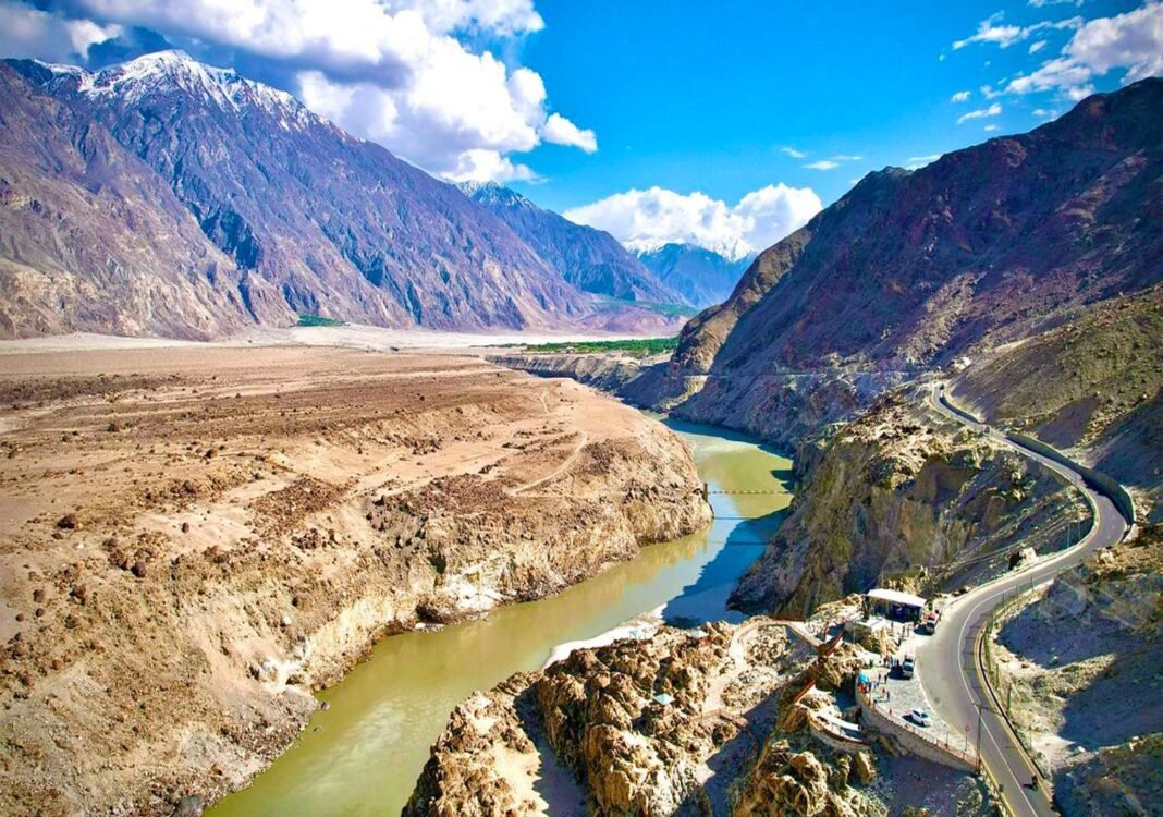
This is the main event. Climb the small sightseeing structure at the marked viewpoint and take your time orienting yourself. Facing the panorama with a little knowledge transforms the view: the great glaciated wall of the Karakoram — home to K2 at 8,611 metres and the densest concentration of high peaks on Earth; the Himalaya sweeping southeast toward Nanga Parbat (around 8,126 m), the western anchor of the range; and the Hindu Kush running west, its highest summit Tirich Mir (7,708 m) standing over Chitral. Photograph the painted wall as your proof of visit — it is delightfully old-school.
Watch the Indus Meet the Gilgit River
Just as the mountains converge, so do the rivers. The Gilgit River joins the mighty Indus near Jaglot, and the confluence is visible from the highway — two great Himalayan rivers, one silty grey-green and one clearer, braiding together before the Indus begins its long journey south to the Arabian Sea. It is one of the finest river confluences in Pakistan and a wonderful subject for video.
Photograph the Layered Ridgelines
Come in the golden hours — early morning or late afternoon — when the low sun rakes across the ridges and each range shows its character: the Karakoram’s sharp granite and ice, the Himalaya’s massive snow walls, the Hindu Kush’s drier, more rugged profiles. A telephoto lens compresses the layers beautifully; a wide angle captures the sheer scale. Clear autumn days (October–November) give the crispest air.
Pause at JSR Chowk, the Crossroads of the North
A few minutes from the viewpoint, JSR Chowk at Jaglot is where northern Pakistan’s great journeys divide: the Karakoram Highway continues to Gilgit, Hunza, and the Khunjerab Pass into China, while the Skardu road branches east toward the Baltoro and K2. Stand at the chowk with a map and feel the delicious indecision — every direction leads somewhere extraordinary. Most KKH itineraries pass straight through, so it costs nothing to stop.
Combine with a Gilgit Day Trip
The Junction is only 40–45 minutes from Gilgit city, which makes it an easy half-day excursion. Pair it with Gilgit’s bazaars, the Kargah Buddha rock carving, or the riverside parks, and you have a full, satisfying day. Travelers heading onward can read our Gilgit travel guide and Gojal (Upper Hunza) travel guide to plan the next legs.
Famous Places In and Around Junction of Three Mountain Ranges
- Gilgit city — the regional capital, 40–45 km away, with bazaars, the Kargah Buddha, and the gateway to Hunza.
- Nanga Parbat viewpoint — further along the KKH, with stunning views of the 8,126-metre “Killer Mountain.”
- Skardu road turn-off — the eastern arm at Jaglot leads to Skardu, the Baltoro Glacier, and Concordia (see our Concordia travel guide).
- Hunza Valley — straight up the KKH from Gilgit; Karimabad is one of Pakistan’s most loved destinations (see our Aliabad Hunza travel guide).
- Rakaposhi viewpoint — on the KKH toward Hunza, framing the magnificent 7,788-metre Rakaposhi.
How to Reach Junction of Three Mountain Ranges
Getting to the Junction is as simple as driving the Karakoram Highway between Chilas and Gilgit — the viewpoint sits right on the road near Jaglot, and you literally cannot miss it if you are watching for the painted wall and the small viewing structure. There is no entry ticket, no trek, and no jeep track: any roadworthy car, van, or bus on the KKH passes it.
From Islamabad: about 480–510 km via the Karakoram Highway (N-35) through Abbottabad, Mansehra, Besham, and Chilas to Jaglot — roughly 10 to 12 hours of driving, usually split with an overnight stop in Besham or Chilas. This is one of the world’s great road journeys.
From Lahore: about 750–800 km, best done via Islamabad (add 4–5 hours to the Islamabad timing above). Most Lahore travelers overnight in Islamabad before starting the KKH.
From Karachi: over 1,800 km by road — realistically a two-day journey via Islamabad. Flying to Islamabad or Gilgit is far more sensible.
From Gilgit: only 40–45 km southeast on the KKH, about 45 minutes to an hour. This is the easiest approach — a half-day trip from any Gilgit hotel.
By air: PIA operates flights from Islamabad to Gilgit (about an hour, spectacular views of Nanga Parbat en route), but they are weather-dependent and frequently cancelled. Skardu’s airport, with more reliable service, is the alternative — then drive back via the Jaglot road.
Transport options: NATCO and other coach services run Islamabad–Gilgit daily; private cars and rented 4x4s are common; and nearly every Hunza/Skardu tour van passes the Junction — just ask your driver to stop. Tell them in advance, because otherwise they will not.
Route Details
- Islamabad → Jaglot: N-35 (Karakoram Highway) north through Mansehra and Besham, on through the Indus gorge past Chilas. After Chilas, the road climbs toward the viewpoint zone near Jaglot. Watch for the painted wall reading “A Junction Point of the three mightiest mountain ranges of the world.”
- Gilgit → Jaglot: Take the KKH southeast out of Gilgit for 40–45 km. The viewpoint and JSR Chowk are well before you reach Chilas.
- At the site: Park off the highway shoulder, climb the small viewing structure, and spend 30–60 minutes with the panorama and the river confluence.
The KKH is open year-round, but winter snow and summer landslides can cause temporary closures, especially around Chilas and the Diamer section. Check road status before a winter trip, carry warm layers even in summer, and fill fuel in Chilas or Gilgit — stations are sparse in between.
Where to Stay in Junction of Three Mountain Ranges
There are no hotels at the viewpoint itself — it is a roadside stop, not a town — so you will sleep in Gilgit city, 40–45 km away, which has the widest range of accommodation in the region. Gilgit suits every budget, and the drive to the Junction makes a perfect lazy morning excursion.
Mid-range and upper-mid hotels: Gilgit’s main bazaar road and the Jutial area have comfortable hotels with hot water, heating (essential in winter), Wi-Fi, and restaurants serving Pakistani and Chinese dishes. These are the sweet spot for most travelers — clean, warm, and well-located for onward trips to Hunza or Skardu.
Budget hotels and guesthouses: Dozens of simpler hotels cluster around the bus stands and bazaar. They are basic but perfectly serviceable for a night or two, and the money you save goes straight into the road trip fund.
Luxury options: A handful of higher-end hotels and resorts operate in and around Gilgit, with better heating, room service, and mountain views. Book ahead in the peak summer season (June–August), when Gilgit fills up.
Camping: Not practical at the viewpoint itself — it is an exposed highway shoulder. Camp instead at designated sites around Gilgit or onward in Hunza, where the infrastructure exists.
If you are passing through on a longer KKH journey, Chilas (to the south) also has simple hotels, but Gilgit is the far better base: better food, better beds, and the Junction is an easy morning drive away.
Where to Eat: Local Foods of Junction of Three Mountain Ranges
Eat in Gilgit, before or after your viewpoint stop — the highway near Jaglot has only basic dhabas. Gilgit-Baltistan’s cuisine is one of Pakistan’s most distinctive, shaped by high valleys, short growing seasons, and centuries of Central Asian influence.
Chapshuro: The signature meat pie of Gilgit-Baltistan — minced beef or yak meat with onions sealed in wheat dough and baked. Hearty, delicious, and the definitive taste of the region.
Mamtu: Delicate steamed dumplings filled with minced meat, served with chutney or yogurt. A comfort food found across the northern valleys.
Dawdo: A warming wheat-noodle soup, perfect after a cold morning at the viewpoint.
Trout: Fresh river trout, usually pan-fried simply, is a highlight of the region’s restaurants.
Apricot everything: Gilgit-Baltistan is apricot country. Dried apricots, apricot oil, and apricot jam are sold everywhere — buy the dried fruit as trail snacks for the KKH.
Namkeen chai (salted tea): The traditional pink salted tea of the mountains, an acquired taste that grows on you fast at altitude.
Meals in Gilgit are budget-friendly. Roadside dhabas between Chilas and Gilgit serve fresh daal, chicken karahi, and rotis — eat where the truck drivers eat and you will eat well.
Weather in Junction of Three Mountain Ranges
At around 2,000 metres, the Junction viewpoint sits in a transitional climate — far milder than the high valleys of Hunza and Skardu, but with real mountain weather. Summers are warm and dry, winters are cold with occasional snow, and the shoulder seasons are glorious. The viewpoint is exposed, so wind chill matters: it always feels cooler on the platform than in Gilgit town.
| Season | Temperature Range | Conditions |
|---|---|---|
| Winter (Dec–Feb) | -5°C to 10°C | Cold, crisp, occasionally snowy; the KKH usually stays open but check for closures. Superb visibility on clear days. |
| Spring (Mar–May) | 8°C to 28°C | Blossoming valleys, warming days, snow still on the high peaks. Lovely for photography. |
| Summer (Jun–Aug) | 20°C to 35°C | Warm and dry at the viewpoint; peak tourist season. Afternoon clouds can obscure distant peaks. |
| Autumn (Sep–Nov) | 5°C to 25°C | Clear skies, golden foliage in the valleys, the sharpest mountain views of the year. |
For the classic experience — blue skies, visible peaks, comfortable platform time — aim for April to June or September to November. Monsoon barely touches this rain-shadow zone, which is why summer works here when it does not in the Himalayan foothills.
Language and Culture of Junction of Three Mountain Ranges
Jaglot sits in the Shina-speaking belt of Gilgit District. Shina is the everyday language of Gilgit town and the surrounding valleys, while Burushaski dominates Hunza and Nagar to the north, Wakhi is spoken in upper Hunza and Ishkoman, and Khowar and Balti are heard from travelers passing through. Urdu works everywhere in the tourism economy, and English is widely understood in hotels.
The people of Gilgit-Baltistan are famously welcoming to travelers — tourism is a pillar of the local economy, and the region has a long tradition of hosting everyone from Silk Road traders to modern backpackers. The population is predominantly Muslim (with Shia, Sunni, and Ismaili communities living side by side), and the culture blends mountain pragmatism with genuine warmth.
Visitor etiquette is straightforward: dress modestly (this matters more in villages than in Gilgit town), ask before photographing people, and accept the tea you will inevitably be offered. Bargaining in bazaars is expected but gentle. If you are invited into a home, remove your shoes and let your host guide the customs — you will be looked after splendidly.
Shopping in Junction of Three Mountain Ranges
Do your shopping in Gilgit’s bazaars, 40 minutes from the viewpoint — the highway stop itself sells nothing but the view.
Gemstones: Gilgit-Baltistan’s mines produce aquamarine, topaz, tourmaline, and quartz. Gilgit’s gemstone shops are the real thing, but buy only from reputable dealers and get a certificate for expensive stones.
Dried apricots, apricot oil, and walnuts: The classic edible souvenirs of the north. Apricot oil is prized locally for cooking and skincare.
Woolen shawls, caps, and socks: Hand-knitted woolens from the valleys are warm, authentic, and cheap by city standards. The traditional Hunza cap makes a great gift.
Local handicrafts: Woodwork, embroidered bags, and traditional jewelry appear in the main bazaar. Quality varies — handle before you buy.
Local Events and Festivals
Shandur Polo Festival (July): The most famous event in the region, held each July at the Shandur Pass (around 3,700 m) between Gilgit and Chitral. Teams from Gilgit and Chitral contest polo on the world’s highest polo ground, with folk music, dancing, and camping under the stars. If your KKH trip falls in July, routing via the Junction to Shandur is an unforgettable combination — book transport and tents well ahead, as the pass fills up.
Travel Tips for Junction of Three Mountain Ranges
Packing Essentials
Layers are everything. Even in summer, the viewpoint’s exposure means wind and sudden cool spells — pack a windproof jacket year-round. Sunglasses, sunscreen, and a hat are essential at this altitude and glare. Bring binoculars if you have them: picking out K2’s direction and tracing the three ranges is half the fun. A power bank, drinking water, and snacks cover the stop itself, since there are no shops at the viewpoint.
Safety Tips
The Junction is one of the safest and simplest stops in northern Pakistan — a roadside viewpoint on a busy highway, in daylight, with constant traffic. The usual KKH cautions apply to the journey rather than the stop: check road conditions in winter and the monsoon season, avoid driving the Chilas–Gilgit section after dark (landslide risk and limited visibility), and keep fuel topped up. Altitude here (around 2,000 m) is mild, but if you are continuing to Hunza or Khunjerab, ascend gradually and stay hydrated.
Money & Connectivity
Carry cash in rupees. Gilgit has banks and ATMs, but they can run dry in peak season — withdraw in Islamabad or at the start of your trip. Mobile coverage (notably SCOM, plus Jazz, Telenor, and Zong in towns) works along the KKH corridor including Jaglot, though data can be slow. Download offline maps for the KKH before leaving Islamabad.
Best Time to Visit Junction of Three Mountain Ranges
April to June — Spring into Early Summer
Blossom in the valleys, snow still crowning every peak, warming days, and moderate crowds. This is arguably the prettiest window — the mountains look their most dramatic against fresh snow.
July to August — High Summer
Peak season: warm, dry, fully open roads, and every hotel in Gilgit buzzing. Afternoon haze can soften the distant views, so visit the viewpoint in the morning for the clearest panorama. Combine with the Shandur Polo Festival in July if the dates align.
September to November — Autumn Gold
The connoisseur’s choice. Crystal-clear air, golden poplar and apricot foliage in the valleys, fewer tourists, and the sharpest views of the three ranges all year. October is magnificent.
December to March — Winter Quiet
Cold but often brilliantly clear, with the fewest travelers and the lowest prices. The KKH generally stays open, but confirm road status — heavy snow can close sections temporarily. Pack serious winter clothing.
Final Thoughts
The Junction of Three Mountain Ranges is proof that the greatest travel experiences are not always the hardest to reach. No trek, no permit, no expedition — just a pause on the Karakoram Highway at the one spot on Earth where the Himalaya, the Karakoram, and the Hindu Kush meet. It is the kind of place that rearranges your sense of scale: you arrive thinking of it as a photo stop and leave thinking about plate tectonics, Silk Road caravans, and how small and lucky you are to stand there at all.
So on your next northern areas trip, tell your driver to stop at Jaglot. Climb the little platform, read the painted wall, and take the panorama slowly — Karakoram, Himalaya, Hindu Kush, all in one turning of the head. Then keep driving, because every road from this crossroads leads somewhere extraordinary. Plan the rest of your journey with our Explore Pakistan guides.
FAQs
Where is the Junction of Three Mountain Ranges?
Near Jaglot town, about 40–45 km southeast of Gilgit on the Karakoram Highway in Gilgit-Baltistan. A painted wall and a small viewing structure mark the viewpoint.
Which three mountain ranges meet there?
The Himalaya, the Karakoram, and the Hindu Kush — the only place in the world where these three great ranges converge.
What is the best time to visit the Junction?
April to June and September to November offer the clearest views and most comfortable weather. October is superb for crisp air and autumn colour. The viewpoint is accessible year-round via the KKH.
How do I reach the Junction from Islamabad?
Drive the Karakoram Highway (N-35) via Besham and Chilas — about 480–510 km, 10–12 hours, usually with an overnight stop. Or fly to Gilgit and drive 40–45 km southeast to Jaglot.
Is there an entry fee or trek involved?
No. The viewpoint is directly on the highway — park, climb the small structure, and enjoy. It is a 30–60 minute stop, free of charge.
Is it suitable for families and elderly travelers?
Absolutely. There is no hiking required; the viewpoint is steps from the road. It is one of the most accessible mountain wonders in Pakistan.
Where should I stay?
Gilgit city, 40–45 km away, has hotels for every budget. The Junction is an easy half-day trip from there.
Can I see K2 from the Junction?
Not the summit itself — K2 lies deep in the Karakoram, far to the east. But you are looking at the Karakoram range that holds it, and the panorama includes some of the world’s greatest glaciated peaks. For the full K2 experience, see our Concordia travel guide.