

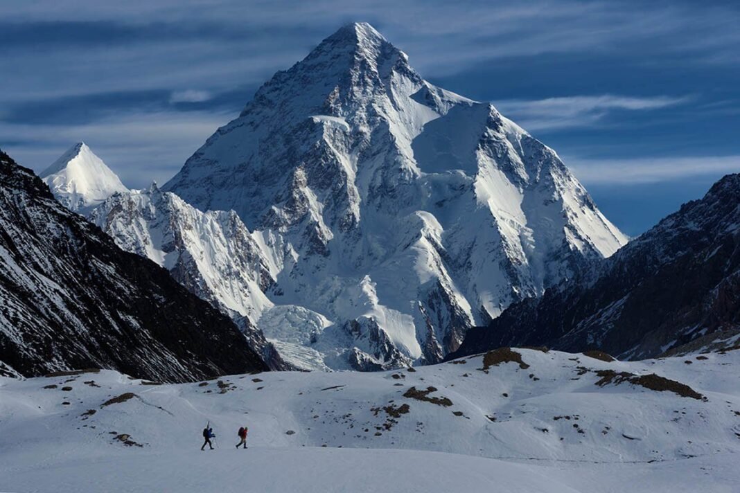
There's a point on the Baltoro Glacier, usually late on the day you walk from Goro to Concordia, when the valley opens up and K2 comes into view at the head of the Godwin-Austen Glacier. At 8,611 metres it's the second-highest mountain on Earth. From Concordia it looks more like a perfect pyramid than the photos suggest. Plenty of trekkers say this one view was worth the whole trip.
In short: The K2 Base Camp Trek crosses the 63 km Baltoro Glacier from Askole to Concordia and K2 Base Camp at about 5,000 metres. The season runs from mid-June to early September, foreign trekkers need a restricted-zone permit through a licensed operator, and there are no lodges after Askole — roughly two weeks are spent in tents.
The K2 Base Camp trek is one of the great walks in the world, and it's a serious one. There are no teahouses, no lodges and no villages after Askole. For roughly two weeks you live in tents on moving ice and moraine, surrounded by more big peaks than anywhere else on the planet. Here's what to know before you go: the route, season, permits, fitness, costs, gear, altitude safety, and the Balti people who make it all possible.
Why the Baltoro Is Different
The Baltoro Glacier is one of the longest glaciers outside the polar regions, about 63 kilometres long. Walking up it takes you past the Trango Towers, Paiju Peak, Masherbrum (K1), Mitre Peak, Gasherbrum IV, Chogolisa and Broad Peak. At Concordia, where the Baltoro meets the Godwin-Austen Glacier, you can see four 8,000-metre peaks: K2, Broad Peak, Gasherbrum I and Gasherbrum II. Concordia is often called the "throne room of the mountain gods," and the name fits.
The trek isn't hard because of technical climbing, since there's none up to K2 Base Camp. It's hard because of the remoteness, the altitude, the rough glacier and the length, which add up day after day.
The Route, Day by Day
Itineraries differ by operator and by how fit the group is, but the classic in-and-out trek from Skardu usually takes 14 to 18 days on the ground. Altitudes below are approximate, and different sources give slightly different figures.
Skardu (about 2,230 m)
Most trekkers fly from Islamabad to Skardu, or drive the Karakoram Highway and the Jaglot–Skardu road if the flight is cancelled. Plan at least one full day in Skardu to finish paperwork, attend the permit briefing, check gear and buy anything you're missing in the bazaar.
Skardu to Askole (about 3,000 m)
You drive by jeep through the Shigar Valley and up the Braldu Valley. Depending on road conditions this takes six to eight hours. The road is narrow and sometimes blocked by landslides or swollen streams, so build in a buffer day. Askole is the last permanent village and the place where loads are weighed and porters are hired.
Askole to Jhola (about 3,200 m)
This is your first walking day. The trail runs along the Braldu River, past the snout of the Biafo Glacier, and then crosses the Dumordo River to reach Jhola. It's hot, dusty and long, so start early and drink plenty. In recent seasons, the jeep track beyond Askole has sometimes cut the walking on this stage. Ask your operator what's current.
Jhola to Paiju (about 3,400 m)
The trail keeps following the Braldu, and you get your first views of the Baltoro's grey snout and the granite spires above it. Paiju is a shady campsite with trees and a spring, the last green place on the route. Most groups take an acclimatisation and rest day here.
Paiju to Urdukas (about 4,000 m)
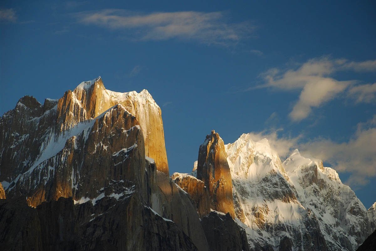
This is where you step onto the glacier. The first hours are a jumble of rubble-covered ice. Later, the Trango Towers and Cathedral Spires rise on your left. Some groups split this stage with a night at Khoburtse. Urdukas sits on grassy terraces above the ice, and it's one of the most beautiful campsites in the Karakoram.
The Trango group rising above the lower Baltoro. Photo: Chogori Adventure
Urdukas to Goro I or Goro II (about 4,300–4,400 m)
From here you're on the glacier for good. The walking follows the medial moraine, the ridges of rock carried down by the ice, with Masherbrum to the south and Gasherbrum IV getting closer ahead. Goro camps are cold and exposed.
Goro to Concordia (about 4,600 m)
This is the big day. Mitre Peak, Gasherbrum IV and finally K2 come into view as you reach the confluence. Most itineraries plan two nights at Concordia, one to rest and acclimatise and one as a spare for bad weather.
Camp life at Concordia, surrounded by the high peaks of the upper Baltoro. Photo: Chogori Adventure
Concordia to K2 Base Camp (about 5,000 m) and Back
It's a long day trip up the Godwin-Austen Glacier, past Broad Peak Base Camp, to K2 Base Camp. Depending on conditions it takes 10 to 12 hours there and back. Near base camp is the Gilkey Memorial, where climbers who died on K2 are remembered. Some groups camp at Broad Peak Base Camp to break up the day.
K2 (8,611 m) from the approach to base camp. Photo: Chogori Adventure
The Return, or the Gondogoro La Option
Most trekkers walk back the way they came, through Goro, Urdukas, Paiju and Jhola to Askole, and then drive to Skardu. Experienced trekkers often go out over the Gondogoro La (about 5,585 m) to Hushe instead.
The usual crossing route goes from Concordia to Ali Camp (about 4,900 m) on the Vigne Glacier. You start from Ali Camp around midnight, so you're on the pass while the snow is still frozen and the risk of rockfall and avalanche is lower. Fixed ropes are normally set each season by a local Hushe rescue team, and there's a fee to use them. Then a steep descent takes you to Khuspang and on through Saicho to Hushe, the first village in the Ghanche district.
The Gondogoro La is a real mountaineering pass. It has steep snow, crevasses and loose rock, so you need crampons, a harness and experienced guides. Whether you cross it depends on the weather and the conditions of the year, and a sensible group will turn back if it isn't safe.
Heading up the Vigne Glacier towards Ali Camp, the start point for the Gondogoro La crossing. Photo: Chogori Adventure
Best Season
The trekking window runs roughly from mid-June to early September. July and August are the most popular months, and they're also the most reliable for the Gondogoro La. Early June can bring deep snow at higher camps, and from mid-September nights get much colder and services start to wind down.
Permits and NOC
K2 and the Baltoro sit in a restricted zone near the border, and they're inside the Central Karakoram National Park (CKNP). Foreign trekkers need:
- A valid Pakistani visa (most nationalities can apply online)
- A trekking permit / NOC for the restricted zone, applied for through a licensed tour operator registered with the Gilgit-Baltistan Department of Tourism
- Payment of the CKNP entry fee
Over the years the rules have changed, including the briefing requirements and whether a liaison officer has to come along for certain routes. Check the current requirements with your operator well before you go. Pakistani citizens trek with fewer formalities but should still go with a registered operator, and they need to pay park fees and register at checkpoints. Carry several photocopies of your passport and visa, because they're checked along the way.
How Fit Do You Need to Be?
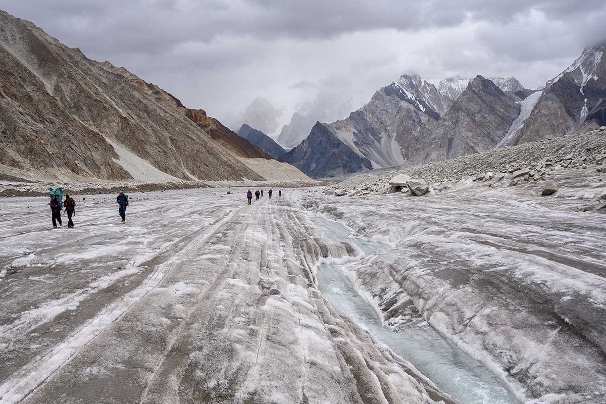
You don't need climbing experience to reach K2 Base Camp, but you do need to be well prepared. Expect to walk six to eight hours on most days, often over unstable boulders and ice, and to put in one or two days of ten hours or more. The best preparation is:
- Several months of regular cardio, such as hiking, running, cycling or stair climbing
- Long weekend hikes with a loaded daypack, ideally back to back
- Leg and core strength work for the uneven glacier ground
- Previous multi-day trekking, ideally above 4,000 metres
If you're planning to add the Gondogoro La, it helps to know how to use crampons and walk on a fixed rope, and you'll need a stronger fitness base.
What Does It Cost?
Prices vary a lot, so be wary of comparing on headline figures alone. The main things that drive the cost are:
- Group size, since fixed costs like the guide, cook and permits are shared
- Inclusions, such as flights to Skardu, hotels, permits, park fees, porter insurance and equipment
- Route, as the Gondogoro La adds a technical team and rope fees
- Standard of service, from tent and mess quality to communications and emergency planning
Pakistani nationals usually pay considerably less than international trekkers, mainly because they don't have the same permit and international costs. Whatever you pay, ask exactly how porters are paid and insured, what happens if a flight is cancelled, and how evacuation would work. A very cheap quote often means corners are being cut on the people who carry your bags.
Gear Checklist
Your operator should supply tents, mess and kitchen equipment. You'll usually bring:
- A sleeping bag rated to about −15 °C, plus a sleeping mat
- Broken-in, waterproof trekking boots, and camp shoes or sandals for river crossings
- Layers: base layers, a fleece, a warm down jacket, and waterproof shell jacket and trousers
- A sun hat, warm hat, buff, glacier sunglasses (category 3–4) and high-SPF sunscreen
- Trekking poles, a 30–40 litre daypack and a large duffel bag for porters
- Water bottles plus a purification method
- A headlamp, power bank or solar charger, and a basic personal first-aid kit
- For the Gondogoro La: crampons, a harness and a helmet (check what your operator provides)
Pack your duffel to the weight limit your operator gives you. Porter loads are regulated, and overweight bags mean extra porters and extra cost.
Altitude Safety
Altitude is the most serious risk on this trek. Acute mountain sickness (AMS) can affect anyone, however fit they are, and it can become life-threatening as high-altitude pulmonary or cerebral oedema (HAPE or HACE). Follow these principles:
- Ascend gradually and use the rest days at Paiju and Concordia
- Drink plenty of water and eat well, even when you don't feel hungry
- Tell your guide straight away about headaches, nausea, unusual breathlessness at rest, confusion or loss of coordination
- Descend if symptoms get worse, because going down is the most effective treatment
- Talk to a doctor before the trip about preventive medication and a personal medical kit
Make sure your travel insurance specifically covers trekking up to about 5,000 metres, or 5,600 metres if you're crossing the Gondogoro La, and covers helicopter evacuation. Helicopter rescue in the Karakoram depends on weather and on arrangements made in advance, so a good operator will have the paperwork ready before you set off.
The Culture of Baltistan
The people of Baltistan speak Balti, a language related to Tibetan, and their history links them to both Tibet and the wider Islamic world. Most Baltis are Muslims, mainly Shia, with Noorbakhshi communities in valleys like Khaplu and Hushe. You'll see wooden mosques and old forts that show this mixed heritage, especially in Shigar and Khaplu.
Hospitality is a big part of life here. If you're offered salty butter tea in a village home, accept it. Dress modestly, ask before photographing people, especially women, and remember that during Muharram some communities hold religious observances that call for respect and quiet.
The Porters
None of this would be possible without Balti porters, mostly men from Askole, the Braldu Valley, Shigar and Hushe. They carry food, fuel and equipment up the glacier in loads limited by regulation to about 25 kilograms. Some also work as high-altitude porters on Pakistan's 8,000-metre expeditions.
Porters taking a well-earned break at Urdukas. Photo: Chogori Adventure
When you choose an operator, ask about porters' wages, insurance, clothing, footwear and shelter on the glacier. Responsible companies give porters proper gear and make sure they have tents and fuel. If you're curious how we handle porter welfare on our own Baltoro trips at Chogori Adventure Pakistan, we're glad to explain. Tipping at the end of the trek is customary and appreciated.
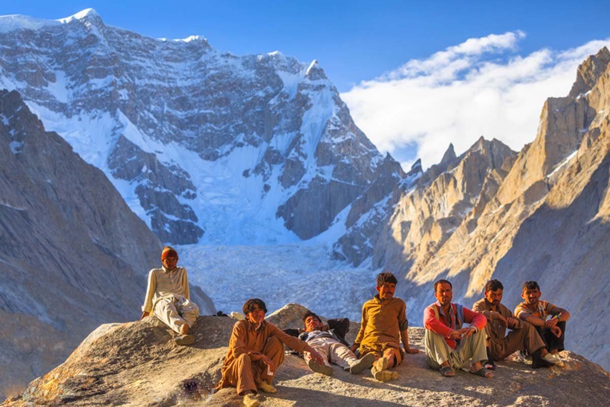
Trekkers and crew sharing a moment on the Baltoro. Photo: Chogori Adventure
Leave No Trace
Waste has long been a problem on the Baltoro, and CKNP and local groups have worked to clean it up. Carry out everything you bring in, use the toilets set up at camps, and avoid single-use plastic.
Frequently Asked Questions
How long is the K2 Base Camp trek?
Most itineraries take 14 to 18 days from Skardu back to Skardu. Add a few days for travel to and from Islamabad and as a buffer for flight delays. The Gondogoro La option usually adds a day or two.
Do I need climbing experience?
Not for the in-and-out route to K2 Base Camp, but you need good fitness and preferably previous multi-day trekking at altitude. For the Gondogoro La you need basic skills with crampons and fixed ropes.
What is the best month to go?
July and August are the most reliable months, especially if you're planning to cross the Gondogoro La. Late June and early September can work well with fewer people, but weather and snow conditions are less predictable.
Can I trek independently?
No. The Baltoro is a restricted zone, and you need a permit arranged through a licensed operator. On a practical level, crossing a glacier this remote without local support isn't safe.
Is there mobile signal or internet?
Coverage usually stops soon after Askole. Many operators carry satellite communication devices for emergencies. Let your family know you'll be out of contact for about two weeks.
Is it safe?
Gilgit-Baltistan has a good record of welcoming trekkers, and the main risks here are environmental: altitude, weather, rockfall and river crossings. Choose an experienced, licensed operator, check your government's travel advice before you go, and have proper insurance.
________________________________________
About the author: Imtiyaz Ahmed is the Managing Director of Chogori Adventure Pakistan, a licensed (GB DTS-GB-055) trekking and expedition company based in Skardu, Gilgit-Baltistan, with a corporate office in Islamabad. Since its founding in 2023, the company has hosted around 150–200 travelers a year on treks and expeditions across the Karakoram and Himalaya.